


12 of the Bowland 1500s - 26th August
Walk Leader – Neil Harwood
Number on walk – 3
Distance – 29 miles
Weather – Improved as the day went on and only wore waterproofs once and for a brief time at that.
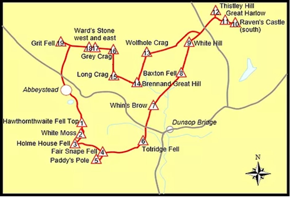
This walk is based upon the Bowland Fell Runners, "Bowland 1500" race. That unfortunately is 40 miles + so I set about seeing if I could create a shorter version that could be walked in a day. I stripped off the five eastern 1500s i.e. Baxton/White Hill and the three further east (i.e. 8-12 on the map below) and also a couple of the “irritants” i.e. Holme House Fell (3) and Long Crag (15). I was left with a 29 mile walk that covered twelve of the 1500.Looking at the map there is an obvious way to cut out the eastern summits by going straight from 7 to 14 (Whins Brow to Brennand Great Hill), although it is considerably easier on a map than on the ground.
I had been planning on doing the walk myself but then, with some trepidation, decided to lead the walk as part of the West Lancs walk programme. I had not expected many people to be interested due to the reputation of these Fells and the length of the walk. But we are the Long Distance Walkers Association and there might be some other similar minded people and it would be great to have company and encouragement along the way. In the end, I had two volunteers, Ian and Stephen, who decided to join me on what would need to be treated as a “challenge” walk. I had planned on it taking us around 11 hours at a decent pace. This is not always easy with the terrain and the lack of paths on parts of the routes. It can be very boggy and there is a lot of working around water. This was not helped by the wet summer and heavy rain for most of the previous night.
We aimed to start at 8.30am but all arrived early so 8.05am was the official start time. The rain had stopped and we could begin to see the tops of the fells so things were looking up. The first couple of miles from Abbeystead is a pleasant walk along the Wyre Way but then the climb up to first of our summits, Hawthornthwaite, is a horror. It initially uses a track but it is incredibly steep in parts but once we reach the fence line and head towards the dislodged trig point, we have gained most of our height for next few hours.
From Hawthornthwaite we follow fences to Fiensdale Head. This section is a foretaste of what is to come for the rest of the day – poor paths, very wet under foot and detours to avoid standing water, well above boot height if not much more. I try not to find out how deep. It also bags us our second summit, the very underwhelming White Moss. The ascent to Fair Snape Fell gives us two more of our twelve, the cairn at the highest point sometimes known as “1707” and also Paddy’s Pole. A brief stop at the later with great views across to the Lancashire coast and then we retrace our steps and set off for Totridge, our fifth summit. The better state of paths is short lived as we find some of the worst crossing of bogs on much of this section. We have a quick lunch at just after noon by the trig point with its plaque in memory of the fell runner Bill Smith, who perished up here in this boggy wilderness.
It is then a steep decent down to Langden Beck and the Trough of Bowland. The sun is out and this beautiful valley lifts the spirits a little after our gruelling morning. However, it is now quite warm just in time for our second climb from the Trough up to Whins Brow, our sixth summit of the day! It is a good path up except for the last part but then, from its trig point, we have three miles of almost pathless heather and bog up the top of the ridge which marks the top of the Northern Bowland Fells. This also includes a third major climb from Brennands Tarn to Wolfhole Crag, summit number eight, via Brennand Great Hill, our seventh summit. Wolfhole Crag gives us a change from the previous three miles with a good path and also the opportunity for a quick teatime break whilst taking in the views south across our route and north to the Yorkshire Three Peaks.
It feels like we have broken the back of the walk but there is still around nine miles left and it is after 4 o’clock. It is then a three mile trek west along the ridge to Ward’s Stone which provides us with two more of our twelve summits and another one on the way, Grey Crag. The views are excellent in the late afternoon sun, with Morecambe Bay glistening in the distance and the Lakes District, an imposing backdrop. It is a quick decent from the second trig point on Lancashire’s second highest hill with a much better path again as it is much more used than most of our day. We make it to shooting access track, which takes us back to Abbeystead, just after six but unfortunately there is another one of those “there and back” summits – Grit Fell, the last and twelfth of the day. But actually, it is a relatively easy climb and excellent under foot so we are there by 6.30pm. A few minutes are spent debating where the summit actually is and then we head back on the final leg. Its all downhill although it is still three and a half miles, so we are back to the cars just after 7.30pm – almost exactly 11 hours in total.
It was a really hard walk and a couple of times I did wonder if I had overstretched myself. But I am glad I did it, and hope my companions are too, but I know for sure that I won’t be doing it again. It is a great challenge and you get to see in a day much of this beautiful wild upland region, which is rightly one of only two AONB’s in Lancashire. Go discover these summits but take your time and choose your paths and day carefully – you will be rewarded with a unique walk. And if you do ever want to try this challenge, respect these hills, reccie it well, pick your day and always remember that fences are your friend.
Thanks again to Ian and Stephen.
For more photos please see the walks database.


