


Lancashire Way Southern Loop
DAY 1 of the LANCASHIRE WAY:- Thursday 8th March 2018 - Croston to Preston
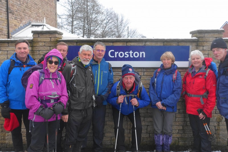
My first time as a leader on the first day of the Lancashire Way turned out to quite an eventful one to say the least. It began the night before whilst watching the weather forecast – snow forecast from about 6am onwards. But they never get it right do they! The plan was to meet in Croston and catch the 8.23am train to Preston and then spend the day walking back to pick up the cars at the end of the day.
At 6am I was up bright and early but out of the window I could see that snow was falling already but it seemed quite wet snow. Almost ready and with lots of time I helped clear the drive so that my son could get on his way to work but shortly after that my clear drive was carpeted in snow. It was getting worse! Then the phone goes – my son is stuck and traffic cannot move. Should we cancel but then Richard rings and tells me that he is in Croston and there are six others, who have managed to get there – most of which had come from much further afield than I was travelling – a mere 20 minutes in normal conditions.
So I prevailed on my wife to go to work via Croston in her 4x4. Traffic is moving slowly but then it is gridlocked in Rufford and I am certainly not going to get there for 8.23am when the train should depart. However, I am on my way and am moving slowly so believe I will get to Croston and we agree that we will catch the next train at 9.49am.
Then I find the road to Croston is closed so I have to say goodbye to my wife and finish the last two miles on foot. I finally arrived at the railway station at about 9.15am but by this point Jacqui, who had arrived first, had been waiting for almost two hours!!
The delay fortunately meant that the intrepid three of John, Ian and Karen had managed to make there way to Croston from Chorley. So excellent – 10 of us now and we just had to wait for the next train at 9.49am. But then we received rumours of the train being cancelled. 9.49am came and went and then Glyn received confirmation that the train was indeed cancelled!! We later discovered that a tree had blocked the line.
After all that effort to get to Croston by us all, it seemed that the day’s walk was doomed. But why not undertake the day in reverse and walk it in the opposite way and then return to Croston at the end of the day by train? The snow had stopped and it did seem to be clearing. The forecast was decent for the afternoon and surely by then the trains would be running again! If not we would be marooned in Preston.
So finally to the walk. Croston to Bretherton with snow filled fields. Then through the pretty village of Bretherton and on to Bank Hall, a Jacobean Mansion from the 17th C, which has finally secured Lottery funding for its restoration. By now the sun was shining and it was relatively warm.
A necessary section along the A59 road enables us to pick the flood embankment that follows the River Douglas for much of the next three miles passing the boatyards at Tarleton on the way. We have lunch at the Dolphin Inn, near Longton. The landlord kindly lets us eat our sandwiches on the benches in the beer garden. And then we follow the Ribble Way into the centre of Preston. The sun is still shining and we can begin to pick out some of the hills of Lancashire to the east including Parlick, Darwen Tower, Pendle Hill and Winter Hill in the distance, all still covered in snow. I do like this part of the walk with its quietness and vast views out to the West – is that Lytham I can see?
Before long we reach the River Ribble and are treated to a brief air show by a Tornado as it circles the BAE airfield at Warton. Its desert livery suggests the Saudis are in town! Then we pick up the flood embankment of the Ribble, which takes us onward to Preston. Finally we reach the beautiful Miller and Avenham Parks and I insist that we finish with a detour around the park and over the river and back. Avenham Walk, the Harris Institute, Winkley Square and St Wilfrid’s Church all are examples of Preston’s rich historical past.
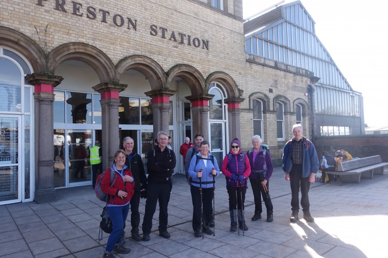
And then the end, or officially the start of the Lancashire Way – Preston Railway Station. And yes the trains are running and on time – there is to be no final twist to the day. Its even raining now but we are in the shelter and warmth of the train – the 16.35 to Croston.
Lets hope that Day 2 of the Lancashire Way is rather more uneventful.
Length of walk – approximately 15 miles. Time taken 6 hours including breaks.
For more details see Stages 1-4 on www.lancashireway.com
To see photos press 'here'
DAY 2 of the LANCASHIRE WAY:- Thursday 15th March 2018 - Croston to Wigan 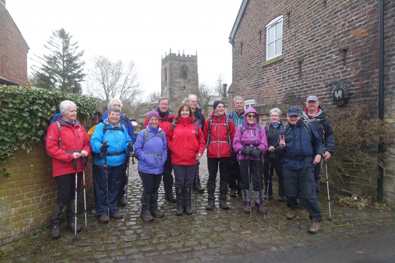
I am pleased to report that Day 2 of the Lancashire Way was considerably less eventful that Day 1!
On this occasion all 14 walkers made it to Croston Railway Station and we even got off five minutes early at 8.25am. We had a schedule to keep as our return bus from the finish in Wigan was at 4.15pm and if we missed that, the next was not until 5.30pm. So onwards through Croston, over the old packhorse bridge, and then south over Mawdesley Moss. The dark skies and occasional shower added to the atmosphere on the West Lancashire plain.
The next section was mainly on the roads through the village of Mawdesley, which is larger than you remember and does go on a little. Then up Sanderson Lane as we start to climb up the side of Harrock Hill – our first real ascent in almost 20 miles of walking. We took our morning break at the top of the lane, which is normally a good viewpoint north across southern Lancashire. However, for almost all of the day, the low clouds and mist spoilt what would have been a great scenic day both west to the coast and east to the Pennines.
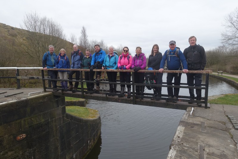
Over Harrock Hill, with a quick detour to the disused windmill, and then on to Parbold Hill via High Moor with the odd muddy stretch. Another great viewpoint but no Welsh Hills today! Down into the Douglas valley and over three forms of transport – rail, canal and river. Then it was the climb up to Ashurst’s Beacon. We had been on schedule until then but the climb and muddy sections put us behind by about 25 minutes and we only had a contingency of 30 minutes!
Lunch was had sat around the beacon with views from Liverpool to the Ribble Estuary. Most of the remainder of the day was down hill or on the flat so hopefully we could make up time. So onward again, down into Roby Mill – an underrated village in my mind. From there we picked up an old tramway from Ayrefield House, with its very friendly goats, which takes us down to the River Douglas again. Under the M6 and then we pick up the Leeds Liverpool canal near Gathurst. We are back on schedule with about 3.5 miles to go along the canal into Wigan.
After Crooke, with its two original canal barges, the route is flat but certainly not pretty. The final stretch is past the DW Stadium and into Wigan Pier and what was the terminus of the Canal in 1777. It would be almost another 40 years before this section was joined up to the rest of the canal from Leeds.
Then on to the bus stop, and after all that worrying, we had made it with around 30 minutes to spare. And of course it was then that the sun finally come out!
Length of walk – approximately 17.5 miles. Time taken 6.5 hours including breaks.
For more details see Stages 5-8 on www.lancashireway.com
To see photos press 'here'
 Day 3 of the LANCASHIRE WAY:- Thursday 22nd March 2018 - Wigan to White Coppice
Day 3 of the Lancashire Way is predominantly a link day taking us from Wigan to the beginning of an exploration of the West Pennine Moors on Day 4 from the village of White Coppice. As such there were large stretches of canal towpath walking, which I don’t think was to everyone’s taste!! However, it does have the advantage of being largely good under foot and with no stiles to climb and can be pretty in places.
And of course there is the history and industrial heritage, so the day began with a brief lesson – as those on the walk will know by now I do like my canals and their fascinating history! We were stood next to the Terminus building at Wigan Pier, which marked the end of the Leeds Liverpool canal in 1777. At that point the coal mined in the Wigan area could only go one way – west down to Liverpool. Previously the River Douglas and its Navigation had been used. It was not until 39 years later, in 1816, that the section of canal that we were about to walk along, was finished and the 127 miles of the Leeds Liverpool canal finally completed. The money kept running out and the Yorkshire and Lancashire investors just could not agree upon the route!
And so on to the walk with a 2.5 miles stretch of canal, which climbs just over 200ft out of Wigan via 23 locks – all with their number in roman numerals. It is a real shame about all the litter, which can spoil what should be a descent walk. At “Top Lock” the canal turns through 90 degrees as it joins what was originally the end of the Lancaster canal, before common sense prevailed and the Leeds Liverpool agreed to share this stretch of canal.
After another half of a mile along the towpath we have a brief detour away from the canal as we explored Haigh Hall and its estate, with its pub named after Lord Balcarres, windmill to pump water up to the brewery that has long since disappeared, cottages, stables and of course the Hall. Our morning break was spent sat on the steps of the school dating from 1846.
Back to the canal! Four miles to Adlington, with lunch near Arley Hall (Wigan Golf Club House). On this stretch we get our first real sighting of Winter Hill. And then another 2 miles before we finally say goodbye to the Leeds Liverpool. But not before ice creams all round at Frederick’s Ice Cream parlour – it probably was not quite warm enough but they did taste great.
The final part of the walk is a lovely end to a days walk as we head under the M61 at Limbrick and on to Healey Nab via Heapey Fold Lane. In spite of the cloud – but no rain all day- the views from the cairn were good. We could even spot the tip of Ashurst’s Beacon from Day 2 on the horizon. Then its downhill to White Coppice making use of the new duck boards on the muddy stretch by the reservoir.
Length of walk – approximately 16.5 miles. Time taken 7 hours including breaks.
For more details see Stages 9-11 on www.lancashireway.com
To see photos press 'here'
 Day 4 of the LANCASHIRE WAY:- Thursday 29th March - White Coppice to Abbey Village
Day 4 is probably the best day of the whole of the Southern Loop of the Lancashire Way. It includes possibly the prettiest Stage from White Coppice to Rivington and then some great hill and moorland walking. It is a shame that it took place so soon after the 40th Anniversary Amble walk on Saturday with which there was a quite a bit of repetition. But I certainly think that any visitor to Lancashire would be amazed by the scenery and views on this part of the Way.
We met at Abbey Village at 8am, which is the end of the walk and took some of the cars to the start at White Coppice. We began at 8.30am, when Hilary arrived who had elected to walk there in training for the Kent 100 in seven weeks time!
It was cold to begin with but before long the sun broke through and the walk along the east side of Anglezarke Reservoir and then a cross over to the west side of the Upper Rivington Reservoir was excellent - the perfect combination of water, sun, blue skies and hills.
Through the village of Rivington, past the Upper Barn and then into the Terraced Gardens of Lord Lever-Hulme. The route climbs through the gardens, via the many steps up to the Dovecote, which was not to everyone’s liking. It is quite a hard slog! So we had our morning coffee break to try and revive spirits but the sun had disappeared and the wind was bitter and shelter was difficult to find.
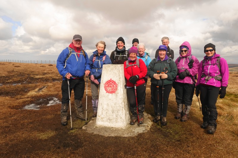
Then more steps up to the Pike before the boggy climb straight up to the summit of Winter Hill. The descent from the top to Hordern Stoops was quite treacherous but the section after the road, which is now flagged/gravelled up to Great Hill was a welcome change and good progress was made. We arrived at the summit just before 1pm – perfect timing for lunch, but unfortunately the sun had long since gone and it was a cold.
From the summit you can see the Pike, the masts of Winter Hill and our next stop of Darwen Tower. So onward down to the Belmont Road at Piccadilly via more bogs and then up to the Tower. We had the first rain of the day and some hail on the steep climb but then the sun came back out and even Great Hill was now bathed in sunshine. There were excellent views from the Tower in all directions.
The final part of the day is largely downhill back to Abbey Village through Tockholes woods and then along the Roddlesworth Reservoirs – another pretty section.
Length of walk – approximately 17.1 miles – 11 walkers. Time taken 8.5 hours including breaks.
For more details see Stages 12-14 on www.lancashireway.com
To see photos press 'here'
 DAY 5 of the LANCASHIRE WAY – Thursday 5th April - Abbey Village to Preston
Day 5 was the final day to complete the 81 miles of the Southern Loop of the Lancashire Way. After the highs of Day 4, I had a little trepidation about the final day – would it be just a trudge back into Preston with little of interest? Initially when developing the route, before the concept of distinct loops had really taken hold, I was to head north from Abbey Village to Hoghton and then straight on with the next part of the walk (the Central Loop), without the need to find another route back into Preston.
However, the day was really good and on the whole merited a day’s walk although I have to admit the beautiful sunny day did help. There was lovely countryside, great panoramic views in all directions and of course that all important canal history!
We began at 8.30am in Abbey village with a walk along the main road before picking up the old Wigan to Blackburn railway line, which is now a Nature Reserve – well maintained too. Then through Wheelton and across Pike Lowe, from which the views were just perfect. Then down into Withnell Fold to the canal – but no time to stop this time, we will leave that until later.
Across the fields to Top O’ Th’ Lane, in Brindle with its magnificent outlook east– could there be a more Lancastrian place name? Then past the plaque marking the site of the old Work House – look it up on line for gruesome tales! But great views west and north from just beyond including the Lakeland Fells – just! And then into Denham Quarry for our morning stop.
The next part of the walk is a little bit of canal nostalgia – you should know by now I do like a canal or two. So along the road to Top Lock (not the one near Wigan – another one) and then down the seven locks at Johnsons Hillock for a history lesson at the junction of two canals. This was one of the last parts of the jigsaw that is the Leeds Liverpool canal – the agreement to use the existing Lancaster Canal finished 13 years earlier to complete the Leeds Liverpool in 1816.
From here we then came back upon ourselves up the Lancaster Canal, or largely what is left of it, in to Whittle-le -Woods. Under the M61 and the remains of the tunnels through Whittle Hills before descending to the A6. We then met up with John, who was to walk the second half of the day, and lunch was taken on the benches around the cricket pitch in Whittle.
The second half of the day walks through Cuerden Park – a pretty valley and an oasis from all the development around – a decent rural entry back into Preston. But shortly after Cuerden Hall, the original route of the Lancashire Way is blocked by the beginning of more development including a new Ikea Store, which forces us to divert via the roads and industrial and retail estates of southern Bamber Bridge. Not great but it is short lived and soon we are back on the original Old Tramway for the final section into Preston. And talking to Gareth, who is a Preston man, I learnt that it is not the old Lancaster Canal Tramway at all but an old railway line. We in fact only reach the tramway just before the Ribble. This really is a lovely way back into Preston and we also meet other members of the West Lancs LDWA who have just been cycling the Guild Wheel!
Through the beautiful Avenham Park and on to Fishergate via Winckley Square. But no bus back to the beginning of the day yet, I had to go back to Preston Railway Station to complete the Southern Loop of the Lancashire Way properly to take photographs to mark the end of our 81 mile trek.
Thank you to you all for joining me on the Lancashire Way – I hope you enjoyed it as much as I did. And I hope you are looking forward to the Central Loop – 101 miles taking in the Ribble and Hodder Valleys, Pendle Hill and the Southern Bowland Fells. It is prettier and there is not one canal - later this year perhaps?
Length of walk – approximately 16.1 miles – 10 walkers. Time taken 6.5 hours including breaks.
For more details see Stages 15-16 on www.lancashireway.com
To see photos press 'here'


