Latest News: Read more


National Trail AcornPennine Way National Trail

Cumbria, Derbyshire, Durham, Gtr Manchester, N Yorkshire, Northumberland, Borders, W Yorkshire

407 km / 253 miles
This first National Trail was formally opened in 1965 after a 30-year campaign led by Tom Stephenson of the Ramblers, and celebrated its 50th birthday in 2015 (24 April). It follows the central upland spine of England from Derbyshire to the Scottish Borders, crossing a wide variety of terrain.

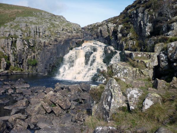
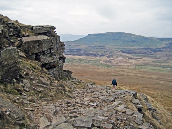
The Way crosses the expanse of the gritstone moorlands of the Kinder Plateau, the Bronte country and the predominantly limestone areas of the Yorkshire Dales National Park which is traversed via Malham, Pen-y-ghent, Great Shunner Fell and Keld. The Way descends from the high fells to reach the River Tees which is followed past High Force and Cauldron Snout waterfalls then crossing the fells to High Cup, Great Dunfell and Cross Fell then descending to Alston to reach the Northumberland National Park and Hadrian's Wall. The Wall is followed to Housesteads Fort before turning north across the Kielder Forest to Redesdale and the uplands of the Cheviot Hills. Here the English-Scottish border fence is then followed before gradually descending to Kirk Yetholm, where it links with the St Cuthbert's Way.

At Alston the Way links with the South Tyne Trail (10 miles), providing a low level alternative up the valley towards Hadrian's Wall.


For National Trails website alerts see 'Pennine Way Interactive Map (National Trails UK)' below.

UPDATE ON PENNINE WAY DIVERSION October 2025
Dryburn Bridge, between Alston and Garrigill, is currently closed due to flood damage. The alternative route will add very little time or distance to your route. Signs will be in place at either end of the diversion. Details of diversion route at: https://www.nationaltrail.co.uk/en_GB/short-routes/dryburn-bridge-closed-follow-diversion/

The LDWA National Trails Register offers certificates for completers of several British National Trails.

See also E-Routes (E2).


Details:

Waymark: National Trail Acorn
Path Type: National Trails (England & Wales)
Waymark: National Trail Acorn
Attributes: National Trail (England and Wales)
Challenging
Moorland
Start: SK123860 - Edale, Derbyshire
Finish: NT828282 - Kirk Yetholm, Borders
Open Date: 1965
Web Sites: National Trails - Pennine Way Independent Hostels UK - Pennine Way Accommodation Yorkshire Dales National Park - Pennine Way Moorland Challenge - Pennine Way Visit Cumbria - Pennine Way Wild Walking UK - Pennine Way [blog] British Walks - Pennine Way [blog] Rambling Man - Planning your Pennine Way Walk Pennine Way [YouTube video] Brian's Walks - Pennine Way [blog] Trailplanner - Pennine Way [blog] Backpack Artist - Pennine Way [blog] Outdoor Scott - Ultimate Guide to the Pennine Way [blog] A walker's journal - The Pennine Way [blog] Chris Stuart's Walks - Pennine Way [blog] Pennine Way Interactive Map (National Trails UK) Waypoint51 - Pennine Way

Publications, Badges and Certificates:

Guidebook Pennine Way: Edale to Kirk Yetholm  (Trailblazer  - 2023 )
Guidebook Pennine Way National Trail from Edale to Kirk Yetholm  (Cicerone Press  - 2025 )
General Interest Book The Pennine Way : the path, the people, the journey  (Cicerone Press  - 2016 )
Guidebook Pennine Way: A Walker's Guide  (Chris Sainty  - 2014 )
Guidebook Heart of the Pennine Way  (Skyware  - 2015 )
General Interest Book Where shall we walk today? : walking the Pennine Way  (CreateSpace Independent Publishing Platform  - 2014 )
Guidebook Circular walks along the Pennine Way  (Frances Lincoln (an imprint of Quarto)  - 2006 )
General Interest Book The Pennine Way  (Frances Lincoln (an imprint of Quarto)  - 2011 )
Guidebook Guide to the Pennine Way  (Constable and Robinson (an imprint of Little, Brown)  - 1991 )
Leaflet Pennine Way: Accommodation & Service  (Pennine Way Project Officer )
General Interest Book Cape to Cape : a 1,250-mile backpacking walk from Cornwall to Cape Wrath in Scotland  (Vertebrate Publishing  - 2018 )
General Interest Book National Trails : 19 long-distance routes through England, Scotland and Wales  (Cicerone Press  - 2015 )
General Interest Book Walking home : travels with a troubadour on the Pennine Way  (Faber & Faber  - 2013 )
Guidebook Pennine Way companion  (Frances Lincoln (an imprint of Quarto)  - 2004 )
Guidebook Pennine Way  (Dalesman  - 1997 )
Guidebook Wainwright on the Pennine Way  (Frances Lincoln (an imprint of Quarto)  - 2014 )
Badge Badge for National Trails  (Trails Shop )
Certificate Certificate for National Trails  (Long Distance Walkers Association )
Certificate Certificate for National Trails  (Trails Shop )
Guidebook Pennine Way : National Trail Guide  (Aurum Press (an imprint of Quarto)  - 2016 )
Other Features of the Pennine Way  (Field Studies Council  - 2006 )
Other National Trail mug  (Trails Shop )
General Interest Book Tales from the Big Trails  (Vertebrate Publishing  - 2021 )
General Interest Book Big Trails: Great Britain & Ireland  (Vertebrate Publishing  - 2020 )

Click to showhide 20 more Publications, Badges and Certificates


Maps:

You can use the interactive controls to zoom in and out and to move around the map, or click on a path or a marker for more info.(interactive map help)

Show Connected Path Outlines
Path Variants
E Routes
National Trails (England & Wales)
Scotland's Great Trails
Paths Marked on OS mapping
Other Paths
Anytime Challenges

Show Accommodation
Hostel Accommodation
Camping Barn
Bunk House
Camp Site
Other
Group Accommodation
Campsite & Bunk Barn

Show Points of Interest
Walkers are Welcome

Contains Ordnance Survey data © Crown copyright and database right 2016.
© OpenStreetMap contributors under Open Database Licence.
Rights of way data from selected Local Authorities.
Large scale digital mapping is provided by John Thorn.
At high zoom levels the route is indicative only.
Purchase Ordnance Survey Maps (path is named on OS maps):
OS Landranger 74, 80, 86, 87, 91, 92, 98, 103, 109, 110
OS Landranger Active 74, 80, 86, 87, 91, 92, 98, 103, 109, 110
OS Explorer 1, 2, 16, 19, 21, 30, 31, 41, 42, 43, 288
OS Explorer Active 1, 2, 16, 19, 21, 30, 31, 41, 42, 43, 288
Other Paper Maps:
Harvey National Trail map
Pennine Way: Set of 2 Maps (Harvey Maps - 2019)
ZigZag 20 Stripmap
Pennine Way 1: Edale to Standedge (Yellow Publications - 2025)
Map (Other)
ZigZag 20 Stripmap
Pennine Way 2: Standedge to Ickornshaw (Yellow Publications - 2025)
ZigZag 20 Stripmap
ZigZag 20 Stripmap
Pennine Way 4: Horton in Ribblesdale to Keld (Yellow Publications - 2025)
ZigZag 20 Stripmap
Pennine Way 5: Keld to Forest-in-Teesdale (Yellow Publications - 2025)
ZigZag 20 Stripmap
Pennine Way 6: Forest-in-Teesdale to Garrigill (Yellow Publications - 2025)
ZigZag 20 Stripmap
Pennine Way 7: Garrigill to Once Brewed (Yellow Publications - 2025)
ZigZag 20 Stripmap
Pennine Way 8: Once Brewed to Byrness (Yellow Publications - 2025)
ZigZag 20 Stripmap
Pennine Way 9: Byrness to Kirk Yetholm (Yellow Publications - 2025)
Map (Other)

Click to show 11 more Other Paper Maps


Accommodation within 5 km of this Path:


From
Path
Along
Path
Hostel Accommodation
2 km
< 1 km
Hostel Accommodation
4 km
< 1 km
Group Accommodation
4 km
< 1 km
Bunk House
4 km
< 1 km
Group Accommodation
5 km
< 1 km
Group Accommodation
5 km
< 1 km
Walkers are Welcome
4 km
6 km
Walkers are Welcome
4 km
36 km
Walkers are Welcome
3 km
43 km
Walkers are Welcome
3 km
60 km
Group Accommodation
1 km
62 km
Bunk House
< 1 km
65 km
Hostel Accommodation
2 km
66 km
Bunk House
< 1 km
73 km
Hostel Accommodation
4 km
83 km
Hostel Accommodation
2 km
102 km
Hostel Accommodation
< 1 km
121 km
Hostel Accommodation
< 1 km
126 km
Bunk House
5 km
133 km
Camping Barn
1 km
163 km
Camping Barn
5 km
165 km
Hostel Accommodation
< 1 km
165 km
Bunk House
< 1 km
166 km
Bunk House
< 1 km
186 km
Group Accommodation
< 1 km
231 km
Hostel Accommodation
< 1 km
250 km
Campsite & Bunk Barn
< 1 km
275 km
Campsite & Bunk Barn
4 km
276 km
Hostel Accommodation
< 1 km
281 km
Group Accommodation
3 km
305 km
Camping Barn
4 km
305 km
Hostel Accommodation
< 1 km
308 km
Bunk House
< 1 km
318 km
Hostel Accommodation
< 1 km
319 km
Other
< 1 km
367 km

Click to show 45 more Accommodations


Additional Images:


Connected Paths:

Scotland's Great Trails
Other Paths
Airedale Way Beacons Way Whalley to Otley Bellingham Trail Berwick Borough Boundary Walk Blackpool to Bridlington (Aerospace Way) Calder Woodland Way Dales Fells Horseshoe Cam High Road to Arten Gill Moss Link Dales Fells Horseshoe Great Shunner Fell to Thwaites Dales Way Watershed Alternatives Dover to Cape Wrath Emblehope Trail Emily Bronte Walk Fielden Trail Friends Way 1: George Fox's Journey GM Ringway Hadrian's High Way Hadrian's High Way - Ardale Beck to Alston Alternative Halifax to Littleborough Herriot Way High Peak 60 Historical Walks through Lancashire and Yorkshire Howgills and Limestone Trail Inn Way ... to the Peak District Joining The Seas Kendal Limestone Way Kinder Loop Kirk Yetholm to Milngavie Lady Anne's Way Lakeland to Lindisfarne Lancashire Trail Land's End to John o' Groats Leeds and Liverpool Canal Walk Manchester Horizon Walk Moss Troopers' Trail North of England Way North West Way Northern Crossway Paulinus Way Peak District Boundary Walk Peak Way Peak Way - Hayfield to Edale Alternative Pennine Odyssey - Buxton to Edale Pennine Odyssey - Garrigill to Cross Fell via Fallow Hill Pennine Odyssey - Garrigill to Cross Fell via Pennine Way Pennine Odyssey - Garrigill to Cross Fell via Tees Head Pennine Odyssey - Hallbankgate to Featherstone Bridge Pennine Odyssey - Langdon Beck to Dufton Pennine Odyssey - Langdon Beck to Garrigill Pennine Odyssey - Main route Pennine Way - Hebden Bridge Loop Rail To Trail Walk - The Bentham Line Railway Heritage Trail Ravenber Way Reiver's Way Richmond Way River Tyne Trail - River North Tyne River Tyne Trail - River South Tyne Roaches to Edale Roman Ring Roof of England Walk Round Manchester Hiking Trail Scottish National Trail Settle to Carlisle Way Six Peaks Trail Sixty Mile Walk around Wensleydale South Pennine Ring St Aelred's Way St Alkelda's Way St Alkeldas Way - Off Road Version St Wilfrid's Way Stanza Stones Trail Steel Cotton Rail Trail Swale Way Three Feathers Walks (Kettlewell) Three Feathers Walks (Yorkshire Bridge) Tidewater Way Tops of the North (Carlisle and Cheviot to Cat and Fiddle) Tops of the North (Three Shire Heads to Carlisle) Trans Pennine Way Trespass Trail Tributaries Walk Two Centre Trek Two Roses Way Two Toms Walk Tyne - Estuary to Source Wark Forest Trail Way of the Roses West Craven Way West Pennine Way - Link To Pennine Way West Yorkshire Heritage Trail Wild Yorkshire Way Wild Yorkshire Way Goredale Scar Alternative Wild Yorkshire Way Tan Hill Inn Alternative Wild Yorkshire Way Wessenden Moor Alternative Yoredale Way Yorkshire Rhino Yorkshire Water Way Click to show 94 more Other Paths

Downloads:

Reminder: Material downloaded from this website is for personal or LDWA use only. Commercial use, reproduction, modification of all content is strictly prohibited without prior approval by the LDWA. Please Contact Us if you have any requests.

GPX Route File
Pennine Way National Trail GPX Exchange Format Route File
Last Updated 25/10/2025 20:52:41 - Dryburn Bridge diversion
Login to Download
(Members Only)
MemoryMap Route File
Pennine Way National Trail Memory Map Route File
Last Updated 25/10/2025 20:52:41 - Dryburn Bridge diversion
Login to Download
(Members Only)
Tracklogs Route File
Pennine Way National Trail Tracklogs Route File
Last Updated 25/10/2025 20:52:46 - Dryburn Bridge diversion
Login to Download
(Members Only)

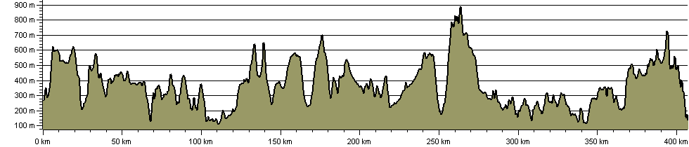
Route Profile:

407.1 km (253.0 miles)
11,203 m (36,755 ft) ascent
890 m (2,920 ft)  maximum height

This website uses cookies

To comply with EU Directives we are informing you that our website uses cookies for services such as memberships and Google Analytics.

Your data is completely safe and we do not record any personally identifiable information.

Please click the button to acknowledge and approve our use of cookies during your visit.

Learn more about the Cookie Law