Latest News: Read more


Richmond Way

Lancashire, N Yorkshire

97 km / 60 miles
The Richmond Way starts from the main gate of Lancaster Castle and ends below the great keep of Richmond Castle in North Yorkshire. The walk encompasses sections of the Lower Lune Valley, the limestone country around Ingleborough and Whernside, the moorlands and fells of the central Pennines and the central and Northern Valleys of the Yorkshire Dales National Park. The route is almost entirely along field, woodland and riverside paths, ancient tracks and quiet country lanes.
From the historic city of Lancaster the route follows the River Lune and its tributary, the Greta, upsteam to Ingleton in North Yorkshire passing through the ancient villages of Halton, Aughton, Melling, and Burton-in-Londsdale.
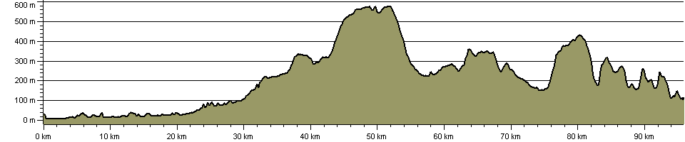
At Ingleton, renowned for its glens and waterfalls, the Richmond Way enters an upland landscape dominated by limestone. The route crosses Scales Moor en route to the head of Ribblesdale where it passes beneath the famous Ribblehead Viaduct. Just beyond Ribblehead, the Richmond Way adopts an old Roman Road which it follows to Wether Fell via Cam End and Dodd Fell Hill. The route reaches 590 metres (1935ft) at its highest point and for 10 exhilarating miles sustains a height above 305 metres (1000ft).
The Richmond Way enters Raydale, a secluded tributary valley of Wensleydale. After exploring the lower reaches of Raydale the route enters Wensleydale the largest of the Yorkshire Dales. After passing through the villages of Bainbridge and Askrigg the Richmond Way seeks out an old drovers? road which it follows to Castle Bolton, whose linear green is dominated by a medieval fortress where Mary, Queen of Scots was imprisoned by Queen Elizabeth I. From Castle Bolton the route strikes out in a northerly direction crossing Redmire Moor before entering Swaledale via the summit of Greets Hill.
The final leg of the Richmond Way starts from the ancient village of Grinton and follows the River Swale downstream to Marrick Priory before exploring the old lead mining villages of Marrick and Marske. Just beyond Marske the route follows a delightful fellside terrace above the looping Swale. On the outskirts of Richmond the route rejoins the Swale which it follows downstream to Richmond Bridge. A final crossing of the Swale is made before the route enters the historically important town of Richmond where it terminates below the great keep of Richmond Castle.


Details:

Path Type: Other Paths
Attributes: Other Paths
Challenging
Moorland
River
Start: SD474618 - Lancaster Castle, Lancashire
Finish: NZ171008 - Richmond Castle, N Yorkshire
Web Sites: Walking Pages - Richmond Way

Publications, Badges and Certificates:

Guidebook Richmond Way: A Walk from Lancaster to Richmond Via the Devil's Causeway  (Cordee Ltd  - 2009 )

Maps:

You can use the interactive controls to zoom in and out and to move around the map, or click on a path or a marker for more info.(interactive map help)

Show Connected Path Outlines
E Routes
National Trails (England & Wales)
Paths Marked on OS mapping
Other Paths
Anytime Challenges

Show Accommodation
Hostel Accommodation
Camping Barn
Bunk House
Group Accommodation

Contains Ordnance Survey data © Crown copyright and database right 2016.
© OpenStreetMap contributors under Open Database Licence.
Rights of way data from selected Local Authorities.
Large scale digital mapping is provided by John Thorn.
At high zoom levels the route is indicative only.
Purchase Ordnance Survey Maps:
OS Landranger 92, 97, 98, 99
OS Landranger Active 92, 97, 98, 99
OS Explorer 2, 7, 30, 41, 296, 304
OS Explorer Active 2, 7, 30, 41, 296, 304

Accommodation within 5 km of this Path:


From
Path
Along
Path
Group Accommodation
1 km
29 km
Hostel Accommodation
< 1 km
30 km
Camping Barn
2 km
54 km
Hostel Accommodation
3 km
55 km
Bunk House
3 km
56 km
Camping Barn
2 km
57 km
Group Accommodation
1 km
75 km
Hostel Accommodation
< 1 km
81 km
Hostel Accommodation
< 1 km
82 km
Hostel Accommodation
< 1 km
94 km

Click to show 11 more Accommodations


Connected Paths:


Downloads:

Reminder: Material downloaded from this website is for personal or LDWA use only. Commercial use, reproduction, modification of all content is strictly prohibited without prior approval by the LDWA. Please Contact Us if you have any requests.

GPX Route File
Richmond Way GPX Exchange Format Route File
Last Updated 17/03/2026 21:09:13 - Previous track was totally inaccurate. Up to 4.5 miles between waypoints.
Login to Download
(Members Only)
MemoryMap Route File
Richmond Way Memory Map Route File
Last Updated 17/03/2026 21:09:13 - Previous track was totally inaccurate. Up to 4.5 miles between waypoints.
Login to Download
(Members Only)
Tracklogs Route File
Richmond Way Tracklogs Route File
Last Updated 17/03/2026 21:09:14 - Previous track was totally inaccurate. Up to 4.5 miles between waypoints.
Login to Download
(Members Only)

Route Profile:

104.6 km (65.0 miles)
2,320 m (7,612 ft) ascent
587 m (1,926 ft)  maximum height

This website uses cookies

To comply with EU Directives we are informing you that our website uses cookies for services such as memberships and Google Analytics.

Your data is completely safe and we do not record any personally identifiable information.

Please click the button to acknowledge and approve our use of cookies during your visit.

Learn more about the Cookie Law