Latest News: Read more


North of England Way

Cumbria, N Yorkshire

327 km / 203 miles
A 200-mile walk across England from Ravenglass on the west coast of Cumbria to Scarborough on the North Sea.

December 2024:The North of England Way follows the road under Dent Head viaduct on the route into Dentdale. A landslip has closed a section of this road "for the foreseeable future". "Although an unsuspecting walker might carefully pass without too much difficulty, the likelihood of further collapse is such that the Westmorland and Furness Council has issued an emergency closure notice for ALL traffic – including walkers and cyclists." Dales Way News.


Details:

Path Type: Other Paths
Attributes: Challenging
Moorland
National Park
Start: SD084964 - Ravenglass, Cumbria
Finish: TA037897 - Scarborough, N Yorkshire

Publications, Badges and Certificates:

Guidebook On foot from coast to coast : the North of England Way  (Michael Joseph (an imprint of Penguin Books)  - 1997 )

Maps:

You can use the interactive controls to zoom in and out and to move around the map, or click on a path or a marker for more info.(interactive map help)

Show Connected Path Outlines
E Routes
National Trails (England & Wales)
Paths Marked on OS mapping
Other Paths
Anytime Challenges

Show Accommodation
Hostel Accommodation
Camping Barn
Bunk House
Group Accommodation

Contains Ordnance Survey data © Crown copyright and database right 2016.
© OpenStreetMap contributors under Open Database Licence.
Rights of way data from selected Local Authorities.
Large scale digital mapping is provided by John Thorn.
At high zoom levels the route is indicative only.
Purchase Ordnance Survey Maps:
OS Landranger 89, 90, 94, 96, 97, 98, 99, 100, 101
OS Landranger Active 89, 90, 94, 96, 97, 98, 99, 100, 101
OS Explorer 2, 6, 7, 19, 26, 27, 30, 298, 299, 301, 302
OS Explorer Active 2, 6, 7, 19, 26, 27, 30, 298, 299, 301, 302

Accommodation within 5 km of this Path:


From
Path
Along
Path
Hostel Accommodation
5 km
11 km
Hostel Accommodation
< 1 km
17 km
Group Accommodation
1 km
34 km
Hostel Accommodation
< 1 km
36 km
Hostel Accommodation
4 km
39 km
Bunk House
5 km
43 km
Hostel Accommodation
1 km
44 km
Hostel Accommodation
2 km
47 km
Hostel Accommodation
4 km
47 km
Bunk House
2 km
50 km
Hostel Accommodation
< 1 km
52 km
Hostel Accommodation
< 1 km
56 km
Hostel Accommodation
< 1 km
62 km
Group Accommodation
4 km
76 km
Camping Barn
1 km
137 km
Hostel Accommodation
< 1 km
139 km
Bunk House
< 1 km
140 km
Camping Barn
2 km
144 km
Group Accommodation
< 1 km
168 km
Bunk House
5 km
189 km
Group Accommodation
< 1 km
296 km

Click to show 23 more Accommodations


Connected Paths:

Other Paths
13 Valleys Trail Abbey Trail Abbeys Amble Ambleside Ale Trail Clough Walk Coastliner Way Coastliner Way - Malton to Whitby Dales Fells Horseshoe Cam High Road to Arten Gill Moss Link Dales Way Watershed Alternatives Eastern Hadrianic Way Fairtrade Way Friends Way 1: George Fox's Journey Friends Way 2: Margaret Fell's Journey Furness Way Grasmere Ale Trail Great Lakes Connection Hadrian's High Way Hadrian's High Way - Ambleside to The Cockpit Alternative Hambleton Hillside Mosaic Walk Herriot Way High Street Stroll Howgills and Limestone Trail Inn Way ... to the Lake District Inn Way ... to the North York Moors Inn Way ... to the Yorkshire Dales John Peel Trail Joining The Seas Lady Anne's Way Lake District Boundary Walk Lake Pickering Circuit Lakeland Haute Route Lakeland to Lindisfarne Lakeland Tour Lakeland Way Lakes and Tarns - Eastern Lakeland Lancashire-Lakeland Link Lastingham Five Churches Trail Miller's Way Newtondale Horse Trail Newtondale Trail North West Way Northern Crossway Palatine Plod Pennine Odyssey - Main route Ravenber Way Richmond Way Rydal Ale Trail Saint Aelred’s Pilgrim Trail Settle To Carlisle - Hill Walk Settle to Carlisle Way Shining Lights of the North Way Six Peaks Trail Sixty Mile Walk around Wensleydale St Aelred's Way St Alkelda's Way St Alkeldas Way - Off Road Version St Bernard's Way Swale Way Tabular Hills Walk Thirlmere Way Three Feathers Walks (Kilburn) Tops of the North (Carlisle and Cheviot to Cat and Fiddle) Tops of the North (Three Shire Heads to Carlisle) Tour of the Lake District Tour of the Lake District - Prologue Tributaries Walk Two Centre Trek Wainwright Memorial Walk Wainwright's Remote Lakeland Wainwrights Way Westmorland Way Whitby Abbeylands Walk Whitby Way White Rose Way Wild Yorkshire Way Wild Yorkshire Way River Swale Alternative Wild Yorkshire Way River Ure Alternative William Wordsworth Way Windermere - Walking Around the Lake Windermere Way Yoredale Way Click to show 78 more Other Paths

Downloads:

Reminder: Material downloaded from this website is for personal or LDWA use only. Commercial use, reproduction, modification of all content is strictly prohibited without prior approval by the LDWA. Please Contact Us if you have any requests.

GPX Route File
MemoryMap Route File
On Foot from Coast to Coast Memory Map Route File
Last Updated 03/03/2017 16:53:19
Login to Download
(Members Only)
Tracklogs Route File
On Foot from Coast to Coast Tracklogs Route File
Last Updated 03/03/2017 16:53:51
Login to Download
(Members Only)

Route Profile:

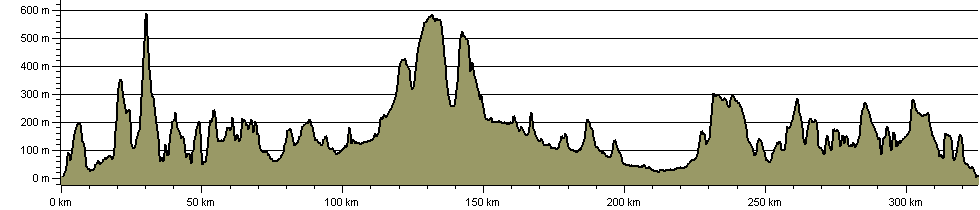
325.5 km (202.3 miles)
7,595 m (24,918 ft) ascent
604 m (1,982 ft)  maximum height

This website uses cookies

To comply with EU Directives we are informing you that our website uses cookies for services such as memberships and Google Analytics.

Your data is completely safe and we do not record any personally identifiable information.

Please click the button to acknowledge and approve our use of cookies during your visit.

Learn more about the Cookie Law