Latest News: Read more


Lapwing head in white on purple background.Roof of England Walk

Cumbria, Durham, N Yorkshire, Northumberland

303 km / 188 miles
"The Roof of England Walk will take you to the far-flung corners of the North Pennines. From high-level traverses across the moor tops and strolls through colourful hay meadows to relaxing riverside walking and woodland stretches – this route has plenty to offer.
Discover the area’s rich mining and industrial heritage and immerse yourself in its glorious nature. Experience unrivalled peace and tranquillity and marvel at sparkling clear, inky-black, night skies.
Feel the wind on your face and the touch of northern rain – we have ‘proper’ weather in the North Pennines. Hear the dramatic and evocative calls of golden plover, curlew and lapwings as they bring the moors alive again in the springtime" ( roofofenglandwalk.org.uk )

Promoted by the North Pennines National Landscape Team. Extensive information is available on the website listed below, the walk being broken down into 14 day sections.


Details:

Waymark: Lapwing head in white on purple background.
Path Type: Other Paths
Waymark: Lapwing head in white on purple background.
Attributes: Other Paths
Challenging
National Landscape
Start and Finish: NY684203 - Appleby-in-Westmorland, Cumbria
Open Date: September 2025
Web Sites: Roof of England Walk

Maps:

You can use the interactive controls to zoom in and out and to move around the map, or click on a path or a marker for more info.(interactive map help)

Show Connected Path Outlines
E Routes
National Trails (England & Wales)
Paths Marked on OS mapping
Other Paths
Anytime Challenges

Show Accommodation
Hostel Accommodation
Camping Barn
Bunk House
Camp Site
Group Accommodation
Campsite & Bunk Barn

Show Points of Interest
Walkers are Welcome

Contains Ordnance Survey data © Crown copyright and database right 2016.
© OpenStreetMap contributors under Open Database Licence.
Rights of way data from selected Local Authorities.
Large scale digital mapping is provided by John Thorn.
At high zoom levels the route is indicative only.
Purchase Ordnance Survey Maps:
OS Landranger 86, 87, 88, 91, 92
OS Landranger Active 86, 87, 88, 91, 92
OS Explorer 19, 30, 31, 43, 307
OS Explorer Active 19, 30, 31, 43, 307

Accommodation within 5 km of this Path:


From
Path
Along
Path
Hostel Accommodation
< 1 km
19 km
Campsite & Bunk Barn
< 1 km
44 km
Campsite & Bunk Barn
4 km
45 km
Hostel Accommodation
< 1 km
51 km
Hostel Accommodation
4 km
71 km
Hostel Accommodation
4 km
82 km
Hostel Accommodation
< 1 km
130 km
Walkers are Welcome
< 1 km
154 km
Bunk House
< 1 km
157 km
Bunk House
1 km
179 km
Group Accommodation
< 1 km
213 km
Bunk House
< 1 km
260 km
Walkers are Welcome
< 1 km
277 km
Hostel Accommodation
< 1 km
277 km

Click to show 16 more Accommodations


Connected Paths:


Downloads:

Reminder: Material downloaded from this website is for personal or LDWA use only. Commercial use, reproduction, modification of all content is strictly prohibited without prior approval by the LDWA. Please Contact Us if you have any requests.

GPX Route File
Roof of England Walk GPX Exchange Format Route File - New trail, new GPX file September 2025
Login to Download
(Members Only)
MemoryMap Route File
Roof of England Walk Memory Map Route File - New trail, new GPX file September 2025
Login to Download
(Members Only)
Tracklogs Route File
Roof of England Walk Tracklogs Route File - New trail, new GPX file September 2025
Login to Download
(Members Only)

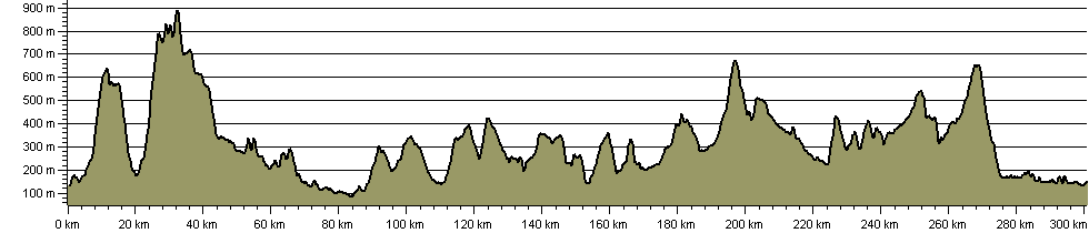
Route Profile:

300.7 km (186.8 miles)
6,899 m (22,635 ft) ascent
890 m (2,920 ft)  maximum height

This website uses cookies

To comply with EU Directives we are informing you that our website uses cookies for services such as memberships and Google Analytics.

Your data is completely safe and we do not record any personally identifiable information.

Please click the button to acknowledge and approve our use of cookies during your visit.

Learn more about the Cookie Law