


The Thames Down Link - AMENDED - REVERSE Kingston to Dorking
Sat 16th Dec 2017
Walk Details:
Event Details Updated
UPDATE 18/11
Note the route has been REVERSED and now runs from Kingston to Dorking, not the other way round as advertised in Strider. Revised details:
Meet at Kingston Station 09:10 (London Waterloo 08:42).
The lunch stop is the same but bring your own food is strongly recommended as the pub could be very busy.
Please bring a torch
Event Type
Group Walk
Region
Southern England
Local Group
London
Distance
18ml.
Start Time
09.10
Route
Meet Kingston Station (London Waterloo 08:42). Finish Dorking station
NOTE ROUTE IS REVERSED COMPARED TO DETAILS BELOW:
The route passes through Denbies Vineyard, Norbury Park, Mickleham and onto Stane Street where we join the Thames Down Link. After lunch at Stamford Green, Epsom Common (9.5 miles), the Link takes us through Horton Country Park Old Malden and Berrylands to finish at Kingston and an optional visit to the nearby Wetherspoons (well it is Christmas)
General Notes
Lunch stop pub (The Cricketers Inn; www.thecricketersinnepsom.co.uk), but bring your own food is STRONGLY RECOMMENDED as the pub could be very busy
Web Site
Start
Finish
Entry Details:
Cost
Walk Report
The Thames Down Link, Saturday 16th December 201720 walkers, 18 miles - leader Keith Lane
The Thames Down Link starts at the mouth of the Hogsmill river as it flows into the Thames at Kingston and finishes at Boxhill and Westhumble Station after approximately 18 miles.
It can be divided into three sections:
* The first follows the Hogsmill river upstream.
* The second is defined by where the Link leaves the river just before Horton Country Park and onto Epsom Common, Ashford Common, and Ashtead Hall Park where there is a nature reserve.
* The third follows Stane Street which is a bridle way following the line of the Roman road which joins up with the present A24 at the foot of Boxhill.
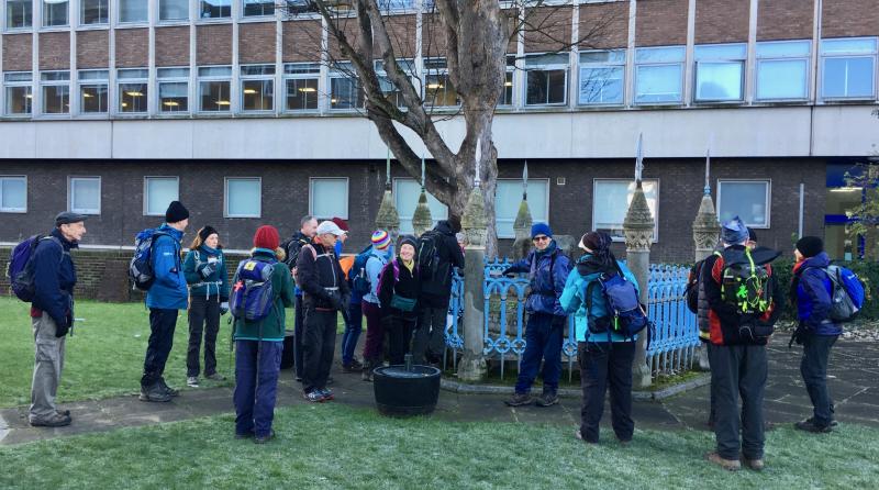
20 walkers met at Kingston station on a freezing but sunny morning and walked through the Market Square now unfortunately spoilt by modern paving and viewed Clattern Bridge which is the oldest bridge in Surrey and the Coronation Stone which currently stands in the grounds of the Guildhall.
At about halfway, lunch was at or near the Cricketers Public House on Epsom Common which was not an ideal venue due to the lack of seating outside but we coped. As the afternoon wore on the weather turned warmer and hence the mud muddier but good time was made and having passed Boxill & Westhumble Station we reached Dorking station via Denbies Vineyard in time for the 16:26 train.
Photograph by Keith Lane; more by Bola Baruwa on the group Facebook page
Other Files
Download Walk ReportGallery
Maps:
You can use the interactive controls to zoom in and out and to move around the map, or click on a marker for more info. (interactive map help)
Contains Ordnance Survey data © Crown copyright and database right 2016.
© OpenStreetMap contributors under Open Database Licence.
Rights of way data from selected Local Authorities.
Large scale digital mapping is provided by John Thorn.
© OpenStreetMap contributors under Open Database Licence.
Rights of way data from selected Local Authorities.
Large scale digital mapping is provided by John Thorn.


