


Wetlands Explorer (linear) REVISED finish point - STRATFORD
Sat 19th Mar 2016
Walk Details:
We'll set off along the Regent's Canal before following the course of the New River to the London Wildlife Trust's future Woodberry Wetlands. We then head down to the River Lea and a riverside pub in Tottenham. After, we do a loop around the site of the LWT's future Walthamstow wetlands before cutting over the Walthamstow marshes and re-joining the Lea, though with a few meanders before reaching the historic Three Mills. From here we head to Stratford and the finish.
Entry Details:
Walk Report
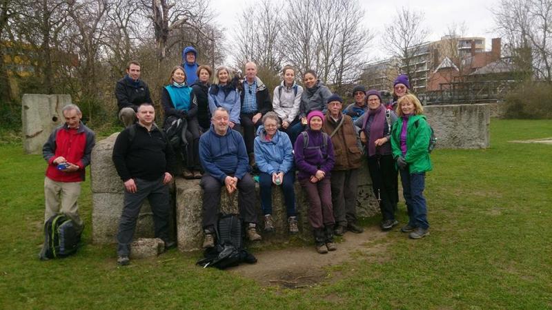
Wetlands Explorer, Saturday 19th March 201626 walkers, 18 miles - leader Peter Aylmer
We started as 24, picked up new members Kyla and Katie at the Angel so peaking at 26, though after lunch at the Ferry Boat Inn in Tottenham one or two split off at intervals for mundane tasks such as cooking the dinner!
The group set off along the Regents' Canal, with a quick detour round Victoria Park, before tracing the course of the New River through Canonbury to Clissold Park in Stoke Newington - a good place for a morning stop. Just beyond here we had a look at the first of two London Wildlife Trust wetlands projects, the Woodberry Wetlands - it opens on 1 May so we were a bit early. A road stretch took us through Stamford Hill on the Sabbath, meeting the Ashkenazi Jewish community on their way to and from the synagogue, the married men resplendent in their brown shtreimels or fur hats - no ear covering alas, or some of us might willingly have borrowed them. The Lea then took us to the Ferry Boat Inn, which had an area ready for us.
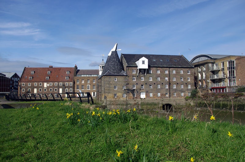
Opposite the pub we entered the Walthamstow Fisheries, currently used for recreational angling but the site of another London Wildlife Trust project to create the Walthamstow Wetlands. When it's ready next year, there will be a through-route to Walthamstow Marshes, but for now we looped round reservoirs 2 and 3 and diverted through a pretty terraced estate by Blackhorse Road tube before reaching the marshes. We were soon back on the Lea, but cut off into the Middlesex Filter Beds - where once the reservoir water was made drinkable, now a nature reserve - where the 'Nature's Throne' artwork was a great place for the afternoon break. The Lea splits into navigation and river at the filter beds, and we chose the latter to continue before heading across Hackney Marshes and the Wick Woodlands before a longer Lea stretch took us to the wonderful Three Mills at Bromley-by-Bow. Had TfL been running the District Line, that would have been the walk end, but instead the twentieth mile took us to the Stratford finish.
Photographs by Peter Aylmer
Other Files
Download Walk ReportGPX
A GPX file of the above route may be downloaded by clicking the link below.
Note: GPX files of Group Walks are created by LDWA Group members, and may be downloaded only by other LDWA members. They should not be made available outside the LDWA, and are used at members' own risk.
Login to Download (Members Only)You can use the interactive controls to zoom in and out and to move around the map, or click on a path or a marker for more info. (interactive map help)
You can use the interactive controls to zoom in and out and to move around the map, or click on a path or a marker for more info. (interactive map help)
© OpenStreetMap contributors under Open Database Licence
Rights of way data from selected Local Authorities
Large scale digital mapping is provided by John Thorn
At high zoom levels the route is indicative only.
Gallery

Maps:
You can use the interactive controls to zoom in and out and to move around the map, or click on a marker for more info. (interactive map help)
© OpenStreetMap contributors under Open Database Licence.
Rights of way data from selected Local Authorities.
Large scale digital mapping is provided by John Thorn.


