


Option C
Sun 11th Feb 2018
Walk Details:
Event Type
Group Walk
Region
Southern England
Local Group
London
Distance
17ml.
Start Time
09.15
Route
Meet Higham Railway Station (08:09 from Charing Cross or 08:25 from St. Pancras)
Last chance to walk the footpaths that will be obliterated by the new lower Thames crossing Option C
General Notes
Picnic lunch. No pubs 'til mid afternoon. Joint with Kent
Web Site
Start and Finish
Entry Details:
Cost
Walk Report
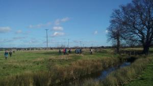
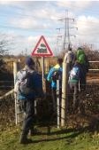
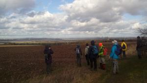
Option C, Sunday 11th February 201822 walkers, 17 miles - leader Peter Jull
Despite an unintended clash with The Punchbowl, 22 gathered under clear blue skies and sheltered from the forecast strong winds at Higham station including one Neil Higham (eventually). Split half from Venus and half from Mars one from Sussex spoilt an equal split betwixt London & Kent. Once off road it was across fairly flat fields to the village of Cliffe. Leaving through the churchyard revealed a sparkling in the sunshine and positively perceived view across the Medway estuary, albeit dominated by the Grain oil terminal, which was over appreciated by one who paused too long photographing and when combined with a bush break was lost off the back. Mutual mobile numbers enabled successful recovery directions to be given. A lakeside gravel track was a break from mud but weaving round plentiful puddles added distance. More weaving through puddly sheep fields was beside a well graffitied freight train waiting to collect gravel from the quarrying that had created the lakes. Across its tracks a few times (twice unintentionally) and Chalk churchyard was chosen for a picnic lunch stop. Walking on was ear bitingly exposed during explanations of which fields would succumb to the cutting and tunnel entrance of the Lower Thames Crossing Option C and across the golf course which would soon become two halves. Local youths on off road motor bikes were churning up woodland paths used to traverse between two footpaths in fields nearest the new A2 junction which will be truncated by the connection. Heading for home involved skirting Shorne Woods Country Park and village and Dickens' Gads Hill home with up and downs now more pronounced. Gathering clouds had produced only one brief whitey shower before the final fields down to the station completed a pleasant winter walk.
Photographs by Peter Jull
Other Files
Download Walk ReportGallery
Maps:
You can use the interactive controls to zoom in and out and to move around the map, or click on a marker for more info. (interactive map help)
Contains Ordnance Survey data © Crown copyright and database right 2016.
© OpenStreetMap contributors under Open Database Licence.
Rights of way data from selected Local Authorities.
Large scale digital mapping is provided by John Thorn.
© OpenStreetMap contributors under Open Database Licence.
Rights of way data from selected Local Authorities.
Large scale digital mapping is provided by John Thorn.


