


Eels, Marbles and Brooks (Linear)
Thu 6th Jul 2017
Walk Details:
Event Type
Group Walk
Region
Southern England
Local Group
London
Distance
9ml.
Start Time
18.00
Route
Meet Twickenham station (17.28 from Waterloo). Finish at sunset or just after at Putney Bridge station (District line)
The title gives some clues for the route!
General Notes
Dogs only allowed by prior agreement with leader and must be under control at all times
Web Site
Start
Finish
Entry Details:
Cost
Walk Report
Eels, Marbles and Brooks, Thursday 6th July 20178 walkers, 9 miles - leader Jerome Ripp
Start 18.00 Finish 21.00
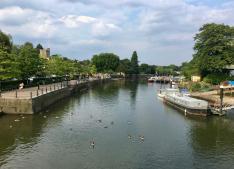
Two first-timers and a handful of faithful regulars set out from Twickenham station on a very hot and sultry evening. A storm seemed to threaten but did not develop and it did get slightly fresher over the walk. The first 2 named highlights were rather non-events as Eel-pie island is private and once over the bridge there is only about 200 metres before the lane finishes and one has to return. Marble hill park is very beautiful but I had chosen the one night in the year when it is closed to the public as a rather noisy charity concert event was taking place and the locked gates and security guards did not suggest that it was worth taking any risks. Along the Thames to Richmond then up Richmond Hill and into the park. Surprisingly quiet for such a lovely summer evening as we crossed to the east to join the Beverly Brook, the 3rd named highlight, which fortunately was flowing in good spirits. The leader's attempts to meet the 10% rule with some off-piste loops on Barnes common were to no avail and everyone made it to Putney Bridge where some dodgy characters made a Rocket for the nearest
Other Files
Download Walk ReportGallery
Maps:
You can use the interactive controls to zoom in and out and to move around the map, or click on a marker for more info. (interactive map help)
Contains Ordnance Survey data © Crown copyright and database right 2016.
© OpenStreetMap contributors under Open Database Licence.
Rights of way data from selected Local Authorities.
Large scale digital mapping is provided by John Thorn.
© OpenStreetMap contributors under Open Database Licence.
Rights of way data from selected Local Authorities.
Large scale digital mapping is provided by John Thorn.


