


The Surrey Semaphore AKA Berrylands to Horsley (Linear)
Sat 6th Aug 2016
Walk Details:
Event Details Updated
Note:
*Amended walk title
* Expanded refreshment options
* Warning ! Lots of overgrown paths so wear shorts at your own risk, you have been warned !
Event Type
Group Walk
Region
Southern England
Local Group
London
Distance
20ml.
Start Time
09.00
Route
Meet Berrylands stn 09.00. (Dep. W'loo 08.36), finish Horsley stn (frequent return trains to London)
A stroll to Horsley taking in lots of delights like the Hogsmill & then continuing on through the Surrey countryside with the highlight being a Semaphore Tower & onto Horsley
General Notes
Pub lunch at The Hare & Hounds in Claygate (sadly not W'spoons )
Also a possible tea / ice cream stop in Cobham !
Warning ! Lots of overgrown paths so wear shorts at your own risk, you have been warned !
Web Site
Start
Finish
Entry Details:
Cost
Walk Report
The Surrey Semaphore AKA Berrylands to Horsley, Saturday 6th August 201623 walkers, 19 miles - leader Dave Williams
22 walkers & 1 leader set off from Berrylands for an odyssey through the Surrey countryside not knowing what to expect & that was just the leader!
However in spite of the leader's inadequacies which became more & more apparent as the day wore on we made good progress and reached Claygate ahead of schedule to enjoy a leisurely lunch & some of us even sampled the local brew with differing verdicts.
Suitably refreshed we set off to cross Esher Common and soon reached Cobham where some of us enjoyed an ice-cream & other local delicacies!
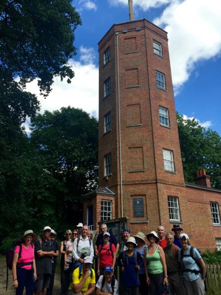
Next we reached the undoubted highlight of the day, the Semaphore Tower at Chatley Heath but sad to say that the magnificence of the structure was completely lost on the majority of the Group, a bunch of cultural heathens with 1 or 2 notable exceptions!
We traipsed on through woodland which afforded us plenty of cover, which was very welcome in the increasingly hot & humid conditions.
We soon reached the sanctuary of Horsley having covered 19 miles with no complaints which was a rarity in itself for me!
Photographs by Keith Lane
Other Files
Download Walk ReportGallery

Maps:
You can use the interactive controls to zoom in and out and to move around the map, or click on a marker for more info. (interactive map help)
Contains Ordnance Survey data © Crown copyright and database right 2016.
© OpenStreetMap contributors under Open Database Licence.
Rights of way data from selected Local Authorities.
Large scale digital mapping is provided by John Thorn.
© OpenStreetMap contributors under Open Database Licence.
Rights of way data from selected Local Authorities.
Large scale digital mapping is provided by John Thorn.


