Latest News: Read more


National Trail AcornHadrian's Wall Path National Trail

Cumbria, Northumberland, Tyne and Wear

135 km / 84 miles
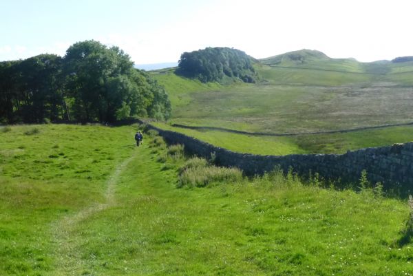
The Trail follows the line of the Wall built in the second century AD by order of Roman Emperor Hadrian as a defensive barrier that continued in use for most of the next 300 years until the Romans finally left our shores in the fifth century. The Wall included milecastles at each Roman mile, some 80 in all, as fortified gateways to control traffic of people and trade. Hadrian's Wall is recognised as a World Heritage Site, Frontiers of the Roman Empire, that includes another later Roman wall further north, the Antonine Wall, that is the basis of an Antonine Trail.

Hadrian's Wall Path provides a fine coast-to-coast walk and if completed east to west first takes the walker from urban and riverside walking on the north bank of the Tyne to farmland above Tynedale. The upland sections along the wild and dramatic escarpments of Whin Sill give way to gentler pastures of Cumbria and finally the Solway estuary and its salt marshes bring the walker to Bowness. An alternative west to east traverse has the benefits of a following wind and access to a city, Carlisle, at an early stage and certain of the guidebooks describe it.

In places the Trail runs close to roads, or on minor roads. To create the Trail footpaths were created where none currently exist in order to provide a line as close to the Wall's remains as is possible, but avoiding interference with it. There are real future concerns for this World Heritage Site and in consequence a 'User Code of Respect' was developed to include recommendations for keeping to signed paths, avoiding interference with the remains and using promoted circular walks especially in wet winter conditions. In response to the intensive use of the main trail in its most vulnerable sections, where in part it coincides for a time with the Pennine Way/E2 E-Route around Housesteads Fort, initiatives such as the Roman Ring and Moss Troopers' Trail and the provision of circular walks based on the Trail seek to spread walkers into the surrounding countryside corridor that has much to offer in scenery and interest.

For National Trails website alerts see 'Hadrian's Wall Path Interactive Map (National Trails UK)' below.

(reviewed August 2026, Paul Nellist)

The LDWA National Trails Register offers certificates for completers of several British National Trails.


Details:

Waymark: National Trail Acorn
Path Type: National Trails (England & Wales)
Waymark: National Trail Acorn
Attributes: Average Gradients
Path Passport
Coast-to-Coast
Moorland
World Heritage Site
Heritage
Start: NZ301661 - Wallsend, Tyne and Wear
Finish: NY225628 - Bowness-on-Solway, Cumbria
Open Date: 2003
Web Sites: National Trails - Hadrian's Wall Path Hadrian's Wall Path Interactive Map (National Trails UK) Visit Northumberland - Hadrian's Wall Walking Routes Independent Hostels UK - Hadrian's Wall Path Accommodation Walking Englishman - Hadrian's Wall National Trail [blog] Hadrian's Wall Path parts 1 to 4 [YouTube video] Historic UK - Hadrian's Wall Trailplanner - Hadrian's Wall [blog] Hadrian's Wall Path National Trail [YouTube video] Walking in the Wild - Hadrian's Wall Path [blog] Outdoor Scott - Guide to the Hadrian's Wall Path [blog] Waypoint51 - Hadrian's Wall Path

Publications, Badges and Certificates:

Guidebook Hadrian's Wall Path: Wallsend to Bowness-on-Solway  (Trailblazer  - 2026 )
Guidebook Hadrian's Wall Path  (Sparky Walking Guides  - 2026 )
Guidebook Hadrian's Wall Path  (Rucksack Readers  - 2025 )
Guidebook Hadrian's Wall Path  (Cicerone Press  - 2023 )
Guidebook Trekking the Hadrian’s Wall Path: two-way trekking guide  (Knife Edge Outdoor Guidebooks  - 2024 )
Guidebook Hadrian's Wall Path : National Trail Guide  (Aurum Press (an imprint of Quarto)  - 2016 )
Guidebook Hadrian's Wall : an archaeological walking guide  (History Press  - 2012 )
Guidebook Walk Hadrian's Wall: The 84 Mile Route from Bowness-on-Solway to Wallsend  (Walking Pages  - 2007 )
Path Passport Hadrian's Wall Path Passport  (Trails Shop )
Certificate Certificate for National Trails  (Long Distance Walkers Association )
Certificate Certificate for National Trails  (Trails Shop )
Badge Badge for National Trails  (Trails Shop )
General Interest Book Tales from the Big Trails  (Vertebrate Publishing  - 2021 )
General Interest Book Big Trails: Great Britain & Ireland  (Vertebrate Publishing  - 2020 )
General Interest Book National Trails : 19 long-distance routes through England, Scotland and Wales  (Cicerone Press  - 2015 )
General Interest Book The great wall of Britain : a walk along Hadrian's Wall  (Hayloft  - 2004 )
Other National Trail mug  (Trails Shop )

Click to showhide 13 more Publications, Badges and Certificates


Maps:

You can use the interactive controls to zoom in and out and to move around the map, or click on a path or a marker for more info.(interactive map help)

Show Connected Path Outlines
E Routes
National Trails (England & Wales)
Paths Marked on OS mapping
Other Paths

Show Accommodation
Hostel Accommodation
Camping Barn
Bunk House
Camp Site
Other
Group Accommodation
Campsite & Bunk Barn

Contains Ordnance Survey data © Crown copyright and database right 2016.
© OpenStreetMap contributors under Open Database Licence.
Rights of way data from selected Local Authorities.
Large scale digital mapping is provided by John Thorn.
At high zoom levels the route is indicative only.
Purchase Ordnance Survey Maps (path is named on OS maps):
OS Landranger 85, 86, 87, 88
OS Landranger Active 85, 86, 87, 88
OS Explorer 43, 314, 315, 316
OS Explorer Active 43, 314, 315, 316
Other Paper Maps:
Map (Other)
Hadrian’s Wall Path map booklet (Rucksack Readers - 2025)
ZigZag 20 Stripmap
Hadrian's Wall Path 1: Wallsend to Humshaugh (Yellow Publications - 2024)
ZigZag 20 Stripmap
Hadrian's Wall Path 2: Humshaugh to Lanercost (Yellow Publications - 2024)
ZigZag 20 Stripmap
Map (Other)
Map (Other)
Hadrian's Wall Path (Vertebrate Publishing - 2020)
Map (Other)
Harvey National Trail map
Hadrian's Wall Path (Harvey Maps - 2015)
Stripmap
Hadrian's Wall Path: Map & Guide (Footprint Maps - 2014)

Click to show 6 more Other Paper Maps


Accommodation within 5 km of this Path:


From
Path
Along
Path
Hostel Accommodation
1 km
7 km
Hostel Accommodation
2 km
19 km
Campsite & Bunk Barn
< 1 km
53 km
Bunk House
3 km
56 km
Hostel Accommodation
< 1 km
68 km
Hostel Accommodation
< 1 km
79 km
Camping Barn
< 1 km
84 km
Group Accommodation
< 1 km
84 km
Bunk House
< 1 km
94 km
Hostel Accommodation
1 km
111 km
Hostel Accommodation
1 km
112 km

Click to show 13 more Accommodations


Additional Images:


Connected Paths:


Downloads:

Reminder: Material downloaded from this website is for personal or LDWA use only. Commercial use, reproduction, modification of all content is strictly prohibited without prior approval by the LDWA. Please Contact Us if you have any requests.

GPX Route File
Hadrian's Wall Path National Trail GPX Exchange Format Route File
Last Updated 23/06/2024 11:57:57 - Tyne north bank erosion north of Rockley
Login to Download
(Members Only)
MemoryMap Route File
Hadrian's Wall Path National Trail Memory Map Route File
Last Updated 23/06/2024 11:57:57 - Tyne north bank erosion north of Rockley
Login to Download
(Members Only)
Tracklogs Route File
Hadrians Wall Path Tracklogs Route file
Last Updated 23/06/2024 11:57:58 - Tyne north bank erosion north of Rockley
Login to Download
(Members Only)

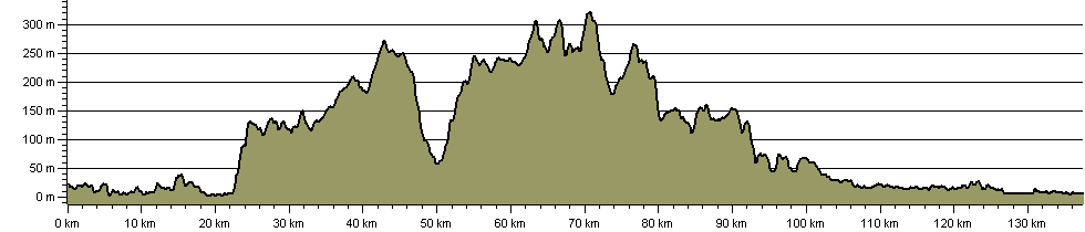
Route Profile:

137.6 km (85.5 miles)
1,780 m (5,840 ft) ascent
325 m (1,066 ft)  maximum height

This website uses cookies

To comply with EU Directives we are informing you that our website uses cookies for services such as memberships and Google Analytics.

Your data is completely safe and we do not record any personally identifiable information.

Please click the button to acknowledge and approve our use of cookies during your visit.

Learn more about the Cookie Law