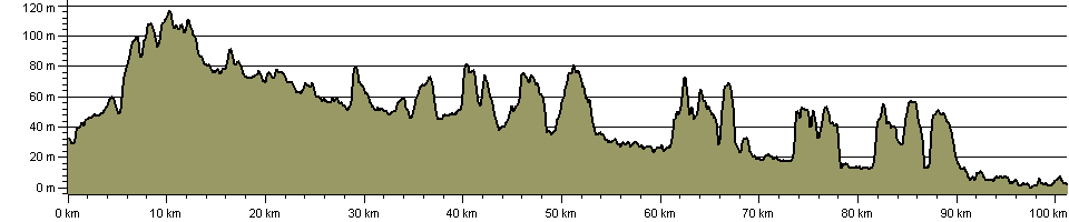
 Stour Valley Path (East Anglia)
See also E-Routes (E2).
| Path Type: | Paths Marked on OS mapping |
| Waymark: | Named discs and posts with stylised river and dragonfly logo |
| Attributes: |
Easy River |
| Start: | TL646635 - Newmarket, Suffolk |
| Finish: | TM101331 - Cattawade, Suffolk |
| Open Date: | 1994 |
| Web Sites: | Stour Valley Path Stour Valley Path (East Anglia) WalkingInTheWild website Griffmonster - Stour Valley Path posts [blog] Annierak - Stour Valley Path [blog] Stephen and Lucy Dawson - Stour Valley Path [blog] Stour Valley Path complete [YouTube video] Stour Valley Path (Discover Suffolk) |
| Guidebook | Stour Valley Path (East Anglia) (Joe Jackson ) |
| Guidebook | Suffolk's Hidden Hiking Trails (Joe Jackson - 2021 ) |
| External download |
Stour Valley Path Guide
(Dedham Vale National Landscape & Stour Valley - 2014 )
 |
| External download |
Section 1: Newmarket to Stetchworth
(Dedham Vale National Landscape & Stour Valley - 2014 )
|
| External download |
Section 2: Stetchworth to Great-Bradley
(Dedham Vale National Landscape & Stour Valley - 2014 )
|
| External download |
Section 3: Great Bradley to Kedington
(Dedham Vale National Landscape & Stour Valley - 2014 )
|
| External download |
Section 4: Kedington to Clare
(Dedham Vale National Landscape & Stour Valley - 2014 )
|
| External download |
Section 5: Clare to Long Melford
(Dedham Vale National Landscape & Stour Valley - 2014 )
|
| External download |
Section 6: Long Melford to Great Henny
(Dedham Vale National Landscape & Stour Valley - 2014 )
|
| External download |
Section 7: Great Henny to Wormingford
(Dedham Vale National Landscape & Stour Valley - 2014 )
|
| External download |
Section 8: Wormingford to Stoke-by-Nayland
(Dedham Vale National Landscape & Stour Valley - 2014 )
|
| External download |
Section 9: Stoke-by-Nayland to Stratford St Mary
(Dedham Vale National Landscape & Stour Valley - 2014 )
|
| External download |
Section 10: Stratford St Mary to Cattawade
(Dedham Vale National Landscape & Stour Valley - 2014 )
|
You can use the interactive controls to zoom in and out and to move around the map, or click on a path or a marker for more info.(interactive map help)
| OS Landranger | 154, 155, 168, 169 |
| OS Landranger Active | 154, 155, 168, 169 |
| OS Explorer | 184, 195, 196, 197, 210, 226 |
| OS Explorer Active | 184, 195, 196, 197, 210, 226 |
Reminder: Material downloaded from this website is for personal or LDWA use only. Commercial use, reproduction, modification of all content is strictly prohibited without prior approval by the LDWA. Please Contact Us if you have any requests.