Latest News: Read more


White dragon-tailed seashell on a blue background with a yellow circletWales Coast Path

Anglesey, Bridgend, Cardiff, Carmarthenshire, Ceredigion, Conwy, Denbighshire, Flintshire, Glamorgan, Gwynedd, Monmouthshire, Newport, Pembrokeshire, Swansea

1370 km / 851 miles
The Wales Coast Path (WCP) opened on 5 May 2012. The path provides a continuous walking route around the whole coast of Wales - from the outskirts of Chester in the north to Chepstow in the south. It is as near to the coast as legally and physically practicable, sometimes going inland, taking into account estuaries and the needs of health and safety, land management and conservation, and with parts still under development with continued funding, in places to secure closer access to the coast. Unlike the England Coast Path that is under development, the Wales Coast Path is not a National Trail and so may not meet the same standards.

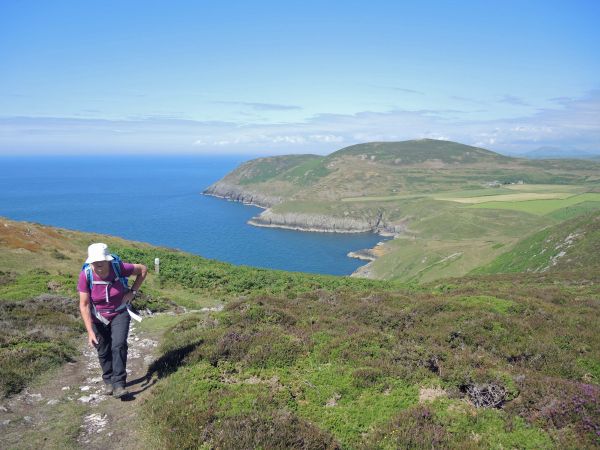
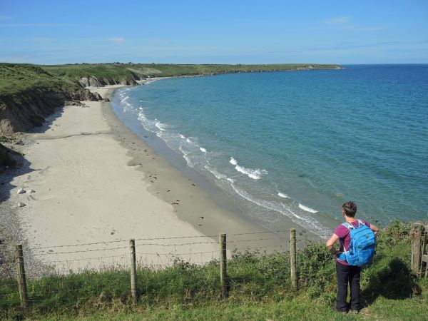
The Welsh coastline has many contrasts: from cliff top strolls to estuarine wanders, picturesque fishing villages to vibrant cities, industrial heritage to unconquered castles, desolate windswept beaches to bustling seasides. The Wales Coast Path not only takes you through the Welsh landscape, it takes you through its heritage and its communities. The North Wales coast is a mixture of wonderful sandy beaches and family friendly towns and villages. Anglesey has world class geology and picturesque beaches and the island is linked to the mainland by the Menai Suspension Bridge built in 1826 by Thomas Telford. With the Snowdonia National Park providing a mighty natural backdrop, around the Ll?n Peninsula, there are small fishing villages, estuaries and miles of sandy beaches. From the dunes of Ynyslas in the north to the historic market town of Cardigan in the south, the majestic sweep of Cardigan Bay affords the walker glimpses of dolphins and porpoise, seals and a host of marine birds. The Ceredigion Heritage Coast has picturesque seaside towns and villages and stunning beaches. The Pembrokeshire Coast is a National Park and has wildlife rich islands. The Path (which has National Trail status here) passes through some of Britain's most spectacular scenery, including 58 beaches and 14 harbours and the UK's smallest city - St Davids. Carmarthen Bay is a coastline of great contrasts and takes in a range of habitats including fresh water marshes, salt marshes, sand dunes, pine forests and coastal commons all supporting a spectacular array of flora and fauna. Set within the bay is Pembrey Country Park - 500 acres of landscaped woods and parkland leading down to the little harbour of Burry Port. From the busy seaside city of Swansea to the stunning coastline of the Gower Peninsula with its award winning golden beaches, the area is home to 10 nature reserves, 24 Wildlife Trust reserves, 32 Sites of Special Scientific Interest and five Special Areas of Conservation. The final southerly coastline takes in city landscapes, village life and magnificent views of the Severn estuary (the estuary has the second highest tidal range in the world at 49 feet and is home to the Severn bore).

The Wales Coast Path has its own waymark. The coastal path uses many existing promoted walking routes, also waymarked in their own right, and listed below as linked pages, as well as some new sections. Existing walking routes included the Pembrokeshire, Gower, Ll?n and Ceredigion coastal routes. In addition to the coastal route, the land border with England is approximated by Offa's Dyke Path, enabling a full circuit of Wales on promoted footpath routes. Outline mapping of all of the full Coast Path and the existing routes is provided on this website using the Show Map links and their side menus for connected and related paths.

Many guidebooks have been published for the various sections of the Path. Path passports are available for each section of the Path and can be downloaded from the Wales Coast Path website.

July 2023: Due to "continuing formation of deep sinkholes" on a road section (The Quays) by the Power Station at Baglan Bay, Neath Port Talbot, the coastal route along Aberavon Sands has been closed off at grid reference SS 731931. A diversion is in place "until further notice" around the perimeter of an industrial estate. (An inland WCP variant, which omits Aberavon Sands and the Power Station, runs between the A48 over Cleveland Bridge and Port Talbot docks.)

23rd November 2023: The Wales Coast Path is closed and diverted due to riverbank / estuary coast erosion on the River Taf between near Laugharne (SN 305109) and Delacorse (SN 307122). The closure is listed as "until 04-03-2025".

1st February 2024: A new 1.2km flyover road and bridge was opened between the northern edge of Machynlleth and the A487, bypassing the 200 year old Pont-ar-Ddyfi bridge across the River Dyfi. The new bridge, which includes a walk/cycle way, crosses the river approximately 480m upstream of the old one. The old bridge remains part of the Welsh Coast Path (WCP), but the new one provides a 'dry' alternative at time of flooding.


For information on these and other temporary WCP diversions see https://www.walescoastpath.gov.uk/latest-news/temporary-path-diversions/?lang=en


Details:

Waymark: White dragon-tailed seashell on a blue background with a yellow circlet
Path Type: Paths Marked on OS mapping
Waymark: White dragon-tailed seashell on a blue background with a yellow circlet
Attributes: Challenging
Path Passport
Coastal
Start: SJ386655 - North side of River Dee, near Chester on Wales/England Border, Flintshire
Finish: ST536943 - Chepstow, Monmouthshire
Open Date: 2012
Web Sites: Wales Coast Path Chester Station Canal Link Wales Coast Path - Vale of Glamorgan British Walks - Coast Walk [blog] Conwy County Borough Council - Wales Coast Path Independent Hostels UK - Wales Coast Path Accommodation Visit Monmouthshire - Wales Coast Path Welsh Government - Wales Coast Path Trailplanner - Wales Coast Path / Llwybr Arfordir Cymru [blog] History Points - Wales Coast Path tour Long Walks - The Cambrian Way, Wales Coast Path, Snowdonia Slate Trail [Podcast]

Publications, Badges and Certificates:

Guidebook Wales Coast Path: Llwybr Arfordir Cymru  (Cicerone Press  - 2025 )
Guidebook Wales Coast Path Official Guide: North Wales Coast: Chester to Bangor  (Northern Eye Books  - 2022 )
Guidebook Wales Coast Path Official Guide: Isle of Anglesey: Bangor to Menai Bridge  (Northern Eye Books  - 2024 )
Guidebook Wales Coast Path Official Guide: Llyn Peninsula: Bangor to Porthmadog  (Northern Eye Books  - 2023 )
Guidebook Wales Coast Path Official Guide: Snowdonia & Ceredigion Coast: Porthmadog to Cardigan  (Northern Eye Books  - 2022 )
Guidebook Wales Coast Path Official Guide: Pembrokeshire: Cardigan to Amroth  (Northern Eye Books  - 2021 )
Guidebook Wales Coast Path Official Guide: Carmarthen Bay & Gower: Tenby to Swansea  (Northern Eye Books  - 2021 )
Guidebook Wales Coast Path Official Guide: South Wales Coast: Swansea to Chepstow  (Northern Eye Books  - 2023 )
Guidebook Pembrokeshire Coast Path  (Trailblazer  - 2021 )
Guidebook Pembrokeshire Coast Path : National Trail Guide  (Aurum Press (an imprint of Quarto)  - 2017 )
Guidebook Wales Coast Path : Tenby-Swansea: National Trail Guide  (Aurum Press (an imprint of Quarto)  - 2013 )
Path Passport Wales Coast Path Passport  (Natural Resources Wales )
Guidebook Wales Coast Path : a practical guide for walkers (2nd edition)  (Christopher Goddard  - 2020 )
Guidebook Ceredigion Coast Path  (Ceredigion Tourism Service  - 2008 )
Guidebook Lleyn Peninsula Coastal Path  (Mike Salter  - March 2013 )
Guidebook Carmarthenshire Coastal Trail  (Mike Salter  - 2008 )
External download Wales Coast Path & North Wales Path  (Conwy County Borough Council  - 2012 ) Download
General Interest Book I may be gone for some time : one man's story of his 5,000 mile trek around the British mainland coast  (Vertebrate Publishing  - 2016 )
General Interest Book Welsh wander : an epic trek right around Wales  (Y Lolfa  - 2017 )
General Interest Book Wales at water's edge  (Gomer  - 2012 )

Click to showhide 16 more Publications, Badges and Certificates


Maps:

You can use the interactive controls to zoom in and out and to move around the map, or click on a path or a marker for more info.(interactive map help)

Show Connected Path Outlines
Path Variants
National Trails (England & Wales)
Paths Marked on OS mapping
Other Paths
Anytime Challenges

Show Accommodation
Hostel Accommodation
Bunk House
Group Accommodation

Show Points of Interest
Walkers are Welcome

Contains Ordnance Survey data © Crown copyright and database right 2016.
© OpenStreetMap contributors under Open Database Licence.
Rights of way data from selected Local Authorities.
Large scale digital mapping is provided by John Thorn.
At high zoom levels the route is indicative only.
Purchase Ordnance Survey Maps:
OS Landranger 114, 115, 116, 117, 123, 124, 135, 145, 146, 157, 158, 159, 162, 170, 171, 172
OS Landranger Active 114, 115, 116, 117, 123, 124, 135, 145, 146, 157, 158, 159, 162, 170, 171, 172
OS Explorer 14, 17, 18, 23, 35, 36, 151, 152, 154, 164, 165, 167, 177, 178, 198, 199, 213, 253, 254, 262, 263, 264, 265, 266
OS Explorer Active 14, 17, 18, 23, 35, 36, 151, 152, 154, 164, 165, 167, 177, 178, 198, 199, 213, 253, 254, 262, 263, 264, 265, 266
Other Paper Maps:
Map (Other)
Map (Other)
Harvey National Trail map
Map (Other)
Map (Other)

Click to show 5 more Other Paper Maps


Accommodation within 5 km of this Path:


From
Path
Along
Path
Hostel Accommodation
1 km
< 1 km
Hostel Accommodation
3 km
< 1 km
Walkers are Welcome
2 km
25 km
Walkers are Welcome
1 km
46 km
Group Accommodation
< 1 km
70 km
Hostel Accommodation
< 1 km
79 km
Hostel Accommodation
1 km
93 km
Hostel Accommodation
< 1 km
248 km
Hostel Accommodation
< 1 km
259 km
Group Accommodation
4 km
340 km
Hostel Accommodation
< 1 km
345 km
Hostel Accommodation
< 1 km
345 km
Group Accommodation
5 km
361 km
Group Accommodation
2 km
503 km
Bunk House
3 km
522 km
Bunk House
2 km
549 km
Hostel Accommodation
< 1 km
600 km
Hostel Accommodation
2 km
600 km
Hostel Accommodation
< 1 km
624 km
Bunk House
1 km
633 km
Walkers are Welcome
3 km
712 km
Walkers are Welcome
< 1 km
713 km
Hostel Accommodation
< 1 km
756 km
Hostel Accommodation
< 1 km
756 km
Hostel Accommodation
< 1 km
786 km
Hostel Accommodation
< 1 km
788 km
Bunk House
< 1 km
795 km
Hostel Accommodation
< 1 km
842 km
Hostel Accommodation
3 km
858 km
Hostel Accommodation
< 1 km
873 km
Hostel Accommodation
1 km
885 km
Group Accommodation
1 km
957 km
Hostel Accommodation
< 1 km
974 km
Hostel Accommodation
< 1 km
1038 km
Group Accommodation
< 1 km
1133 km
Bunk House
2 km
1139 km
Bunk House
< 1 km
1142 km
Bunk House
< 1 km
1153 km
Hostel Accommodation
< 1 km
1153 km
Bunk House
< 1 km
1156 km
Walkers are Welcome
1 km
1174 km
Bunk House
< 1 km
1184 km
Hostel Accommodation
< 1 km
1189 km
Bunk House
5 km
1292 km
Group Accommodation
< 1 km
1299 km
Walkers are Welcome
< 1 km
1369 km

Click to show 48 more Accommodations


Additional Images:


Connected Paths:

Anytime Challenges

Downloads:

Reminder: Material downloaded from this website is for personal or LDWA use only. Commercial use, reproduction, modification of all content is strictly prohibited without prior approval by the LDWA. Please Contact Us if you have any requests.

GPX Route File
Wales Coast Path GPX Exchange Format Route File
Last Updated 08/01/2025 19:58:22
Login to Download
(Members Only)
MemoryMap Route File
Wales Coast Path Memory Map Route File
Last Updated 08/01/2025 19:58:22
Login to Download
(Members Only)
Tracklogs Route File
Wales Coast Path Tracklogs Route File
Last Updated 08/01/2025 19:58:41
Login to Download
(Members Only)

Route Profile:

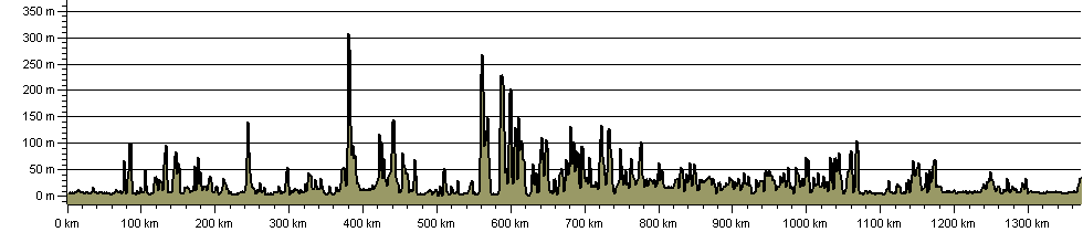
1369.4 km (850.9 miles)
29,200 m (95,801 ft) ascent
352 m (1,155 ft)  maximum height

This website uses cookies

To comply with EU Directives we are informing you that our website uses cookies for services such as memberships and Google Analytics.

Your data is completely safe and we do not record any personally identifiable information.

Please click the button to acknowledge and approve our use of cookies during your visit.

Learn more about the Cookie Law