
Latest News: Read more


Named green discsWeardale Way

Durham, Tyne and Wear

124 km / 77 miles
A route following the River Wear from the sea at the Bede Memorial Cross, Roker to the headwaters in the east Pennines, keeping as close as is possible to the river. After leaving the initially urban surroundings of Sunderland it visits Lumley Castle, Durham (where the Castle and Cathedral forms a World Heritage Site), Bishop Auckland and Stanhope. After Stanhope the Way makes a northward loop to Rookhope to take in part of a tributary, Rookhope Burn.

The Way was upgraded and revised in 2006 with a change to the finish point, previously at Wearhead, now at Killhope. At Wearhead, Killhope and Burnhope Burns combine to form the Wear and the extension is up Killhope Burn.

The River Wear Trail (10 miles and shown on OS Explorer mapping) between Roker and Fatfield runs on both banks of the tidal Wear with parts coincident with the Way.


September 2025. There have been a few reports of problems along this trail. The Durham Cow website, listed below, is the best place to see updates on these issues. The website has a specific updates section.

September 2025. The footbridge at NZ024357, near White Kirkley has been declared closed and is awaiting repair by Durham County Council. As it happens, our available GPX file shows the old, original route in this area, which is actually a currently suitable diversion to avoid the closed footbridge. When the bridge is repaired, our GPX file will be changed to the new route shown on OS mapping.


Details:

Waymark: Named green discs
Path Type: Paths Marked on OS mapping
Waymark: Named green discs
Attributes: Easy
River
Urban
World Heritage Site
Start: NZ407593 - Bede Memorial Cross, Cliffe Park, Roker, Tyne and Wear
Finish: NY825431 - Killhope Lead Mining Museum, near Cowshill, Upper Weardale, Durham
Web Sites: Durham CC - Weardale Way Durham Cow - Weardale Way Weardale Way [YouTube video]

Publications, Badges and Certificates:

Guidebook Weardale Way Pocket Guide  (Walking Books  - 2021 )

Maps:

You can use the interactive controls to zoom in and out and to move around the map, or click on a path or a marker for more info.(interactive map help)

Show Connected Path Outlines
National Trails (England & Wales)
Paths Marked on OS mapping
Other Paths

Show Accommodation
Camping Barn
Bunk House

Show Points of Interest
Walkers are Welcome

Contains Ordnance Survey data © Crown copyright and database right 2016.
© OpenStreetMap contributors under Open Database Licence.
Rights of way data from selected Local Authorities.
Large scale digital mapping is provided by John Thorn.
At high zoom levels the route is indicative only.
Purchase Ordnance Survey Maps (path is named on OS maps):
OS Landranger 86, 87, 88, 91, 92, 93
OS Landranger Active 86, 87, 88, 91, 92, 93
OS Explorer 31, 305, 307, 308
OS Explorer Active 31, 305, 307, 308

Accommodation within 5 km of this Path:


From
Path
Along
Path
Walkers are Welcome
< 1 km
80 km
Bunk House
1 km
82 km
Bunk House
< 1 km
103 km
Camping Barn
4 km
124 km

Connected Paths:


Downloads:

Reminder: Material downloaded from this website is for personal or LDWA use only. Commercial use, reproduction, modification of all content is strictly prohibited without prior approval by the LDWA. Please Contact Us if you have any requests.
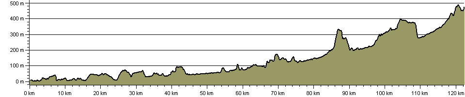

Route Profile:

122.3 km (76.0 miles)
1,981 m (6,499 ft) ascent
493 m (1,617 ft)  maximum height

This website uses cookies

To comply with EU Directives we are informing you that our website uses cookies for services such as memberships and Google Analytics.

Your data is completely safe and we do not record any personally identifiable information.

Please click the button to acknowledge and approve our use of cookies during your visit.

Learn more about the Cookie Law