Latest News: Read more


Thistle within hexagonWest Highland Way

Argyll and Bute, E Dunbartonshire, Highland, Stirling

154 km / 96 miles
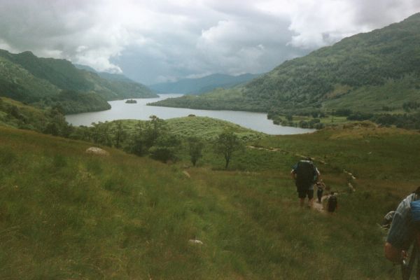
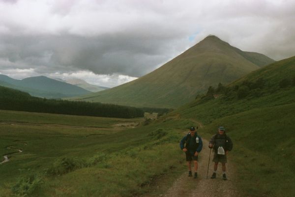
Scotland's first official Long Distance Route, and now one of the family of Scotland's Great Trails, crosses a variety of terrain which becomes more rugged as it moves northwards and between the major mountain groups. The Way follows the eastern side of Loch Lomond, crossing the slopes of Ben Lomond to Crianlarich and Bridge of Orchy, the western edge of Rannoch Moor and the entrances to Glen Etive and Glen Coe, and up and over the Devil's Staircase and the highest point of the route at 550m, to reach Kinlochleven. The final section follows General Caulfield's military road over the slopes of the Mamores, crossing wild country with extensive views of the Ben Nevis range to reach Fort William.

The waymarked Kelvin Walkway (9 miles and on OS mapping) connects Milngavie with the Glasgow Heliport on the north bank of the River Clyde, providing a link into central Glasgow, and this Walkway is included in the Trailblazer guide.


Details:

Waymark: Thistle within hexagon
Path Type: Scotland's Great Trails
Waymark: Thistle within hexagon
Attributes: Scotland's Great Trails
Challenging
Path Passport
Lake/Reservoir/Loch
Moorland
Mountain
Start: NS553745 - Milngavie, E Dunbartonshire
Finish: NN100737 - Bronze statue of walker, Gordon Square, High Street, Fort William, Highland
Open Date: 1980
Web Sites: West Highland Way (Official Website) Scotland's Great Trails - West Highland Way BBC News: The Long Journey of the West Highland Way Independent Hostels UK - West Highland Way Accommodation Undiscovered Scotland - West Highland Way Trailplanner - West Highland Way [blog] Brian's Walks - West Highland Way south to north [blog] Brian's Walks - West Highland Way north to south [blog] A walker's journal - The West Highland Way [blog] Trailwalker - West Highland Way [blog] Baldhiker - Solo Walk along the West Highland Way [blog] Secret Scotland Travel Blog April 2023 Outdoor Scott - Ultimate Guide to the West Highland Way [blog] West Highland Way [YouTube video] West Highland Way - Kevin Augello [YouTube video] Walking the West Highland Way [YouTube video] West Highland Way - Carl Johnson [YouTube video] Tartan Trailblazers - How to Prepare for your West Highland Way

Publications, Badges and Certificates:

Guidebook West Highland Way: Milngavie (Glasgow) to Fort William  (Cicerone Press  - 2025 reprint )
Guidebook West Highland Way  (Rucksack Readers  - 2024 )
Guidebook West Highland Way : Milngavie to Fort William  (Trailblazer  - 2022 )
Guidebook Trekking the West Highland Way: two-way trekking guide  (Knife Edge Outdoor Guidebooks  - 2022 )
Guidebook West Highland Way: the official guide  (Birlinn  - 2018 )
Guidebook West Highland Way : National Trail Guide  (Aurum Press (an imprint of Quarto)  - 2016 )
Guidebook NOT the West Highland Way: diversions over mountains, smaller hills or high passes for 8 of the Way's 9 stages  (Cicerone Press  - 2020 )
Guidebook Fastpacking: multi-day running adventures: tips, stories and route ideas  (Cicerone Press  - 2018 )
Path Passport West Highland Way Passport  (Loch Lomond & The Trossachs National Park )
Certificate Certificate for National Trails  (Long Distance Walkers Association )
Leaflet West Highland Wayfarer  (Famedram Publishing  - Annual )
Other West Highland Way map [artwork]  (Famedram Publishing )
General Interest Book Tales from the Big Trails  (Vertebrate Publishing  - 2021 )
General Interest Book National Trails : 19 long-distance routes through England, Scotland and Wales  (Cicerone Press  - 2015 )
General Interest Book Cape to Cape : a 1,250-mile backpacking walk from Cornwall to Cape Wrath in Scotland  (Vertebrate Publishing  - 2018 )
General Interest Book Three men on the Way Way : a story of walking the West Highland Way  (Whittles Publishing  - 2013 )
Guidebook Walkers' Britain  (Awesome Books  - 2011 )
General Interest Book Big Trails: Great Britain & Ireland  (Vertebrate Publishing  - 2020 )

Click to showhide 14 more Publications, Badges and Certificates


Maps:

You can use the interactive controls to zoom in and out and to move around the map, or click on a path or a marker for more info.(interactive map help)

Show Connected Path Outlines
E Routes
Scotland's Great Trails
Paths Marked on OS mapping
Other Paths
Anytime Challenges
Kanters

Show Accommodation
Hostel Accommodation
Bunk House

Contains Ordnance Survey data © Crown copyright and database right 2016.
© OpenStreetMap contributors under Open Database Licence.
Rights of way data from selected Local Authorities.
Large scale digital mapping is provided by John Thorn.
At high zoom levels the route is indicative only.
Purchase Ordnance Survey Maps (path is named on OS maps):
OS Landranger 41, 50, 56, 57, 64
OS Landranger Active 41, 50, 56, 57, 64
OS Explorer 38, 39, 342, 348, 377, 384, 385, 391, 392, 399
OS Explorer Active 38, 39, 342, 348, 377, 384, 385, 391, 392, 399
Other Paper Maps:
Stripmap
West Highland Way: Map & Guide (Footprint Maps - 2017)
Harvey National Trail map
West Highland Way (Harvey Maps - 2017)
ZigZag 20 Stripmap
West Highland Way 1: Milngavie to Inversnaid (Yellow Publications - 2024)
ZigZag 20 Stripmap
West Highland Way 2: Inversnaid to Inveroran (Yellow Publications - 2024)
ZigZag 20 Stripmap
West Highland Way 3: Inveroran to Fort William (Yellow Publications - 2024)
Map (Other)
West Highland Way (Vertebrate Publishing - 2020)
Map (Other)
West Highland Way map booklet (Cicerone Press - 2024)

Click to show 4 more Other Paper Maps


Walking Support Providers:

Support Providers
Baggage Handling (Great Glen Travel)
Support Providers
Baggage Handling (Travel-Lite)
Support Providers
Support Providers
Guided and Self-Guided Walking Holidays (North-West Frontiers Ltd)
Support Providers
Self-Guided Walking Holidays (Make Tracks Walking Holidays)
Support Providers
Self-Guided Walking Holidays (C-N-Do Scotland)
Support Providers
Support Providers
Self-Guided Walking Holidays (Wilderness Scotland)
Support Providers
Baggage Handling and Self-Guided Walks (Walk & Cycle Britain Limited)
Support Providers
Self-Guided Walking Holidays (Sherpa Expeditions)
Support Providers
Guided Walking Holidays (Thistle Trekking)

Click to show 8 more Walking Support Providers


Accommodation within 5 km of this Path:


From
Path
Along
Path
Bunk House
< 1 km
31 km
Hostel Accommodation
< 1 km
43 km
Bunk House
< 1 km
54 km
Hostel Accommodation
1 km
75 km
Hostel Accommodation
< 1 km
84 km
Bunk House
< 1 km
115 km
Hostel Accommodation
< 1 km
129 km
Hostel Accommodation
< 1 km
149 km
Hostel Accommodation
3 km
153 km
Hostel Accommodation
< 1 km
154 km
Hostel Accommodation
< 1 km
154 km

Click to show 10 more Accommodations


Additional Images:


Connected Paths:


Downloads:

Reminder: Material downloaded from this website is for personal or LDWA use only. Commercial use, reproduction, modification of all content is strictly prohibited without prior approval by the LDWA. Please Contact Us if you have any requests.
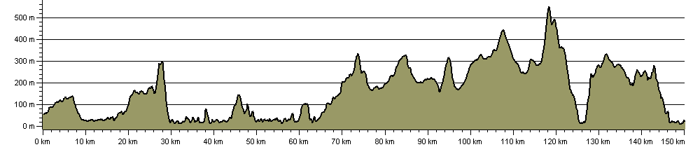

Route Profile:

150.0 km (93.2 miles)
3,946 m (12,946 ft) ascent
552 m (1,811 ft)  maximum height

This website uses cookies

To comply with EU Directives we are informing you that our website uses cookies for services such as memberships and Google Analytics.

Your data is completely safe and we do not record any personally identifiable information.

Please click the button to acknowledge and approve our use of cookies during your visit.

Learn more about the Cookie Law