Latest News: Lean Project Update Read more

Latest News: LDP Update Read more

Latest News: Digital Platform Update Read more

Latest News: Podcasts Read more

Latest News: Hazel Bound Read more


Named discs with two swans on water (Beds); swan, water and tree logo (Cambs)Ouse Valley Way

Bedfordshire, Buckinghamshire, Cambridgeshire, Milton Keynes, Norfolk, Northamptonshire

229 km / 142 miles
A source-to-sea route on one of England's longest rivers, it follows the River Great Ouse on its meandering passage from close to its source to the tidal river at Kings Lynn, linking many towns and villages. It passes through Stowe Park to reach Buckingham, then fringes north of Milton Keynes and Newport Pagnell. It heads via Emberton Country Park to Sharnbrook (with H E Bates connections) and visits Bedford's Priory Park and passes a Danish Camp at Willingdon, then links St Neots, Huntingdon (Cromwell's birthplace), St Ives and Earith. After Earith, the Dutch engineer Vermuyden worked to shorten the river across the Hundred Foot Washes, while the Way keeps along the Old West River where the Stretham Old Engine tells the story of the draining of the Fens. Before Ely, with its cathedral visible on the skyline, it meets the River Cam, and after Ely it runs in common with the Fen Rivers Way, crossing the Bedford Level to Downham Market and Kings Lynn, where the river finally flows out into the Wash.

As it passes from rolling Buckinghamshire countryside to reach open black-soiled fenland landscapes, now sunk some 10ft below the elevated riverbanks, it offers a mixture of riverside and canal walking, sections alongside old flooded gravel pits, and gentle countryside with few other climbs. Some stretches leave the river to avoid areas flood-prone in winter and there is some road walking, some alongside busy roads.

The former Ouse Valley Walk (13 miles) follows the River Great Ouse between Buckingham and Milton Keynes and connects with the North Bucks Way at Iron Viaduct.

October 2025 - The road bridge (and its footway) over the River Great Ouse near Thornton, Buckinghamshire (grid reference SP 751365) is reported to be closed for repairs. There is no serviceable foot alternative other than an unclassified road walk. The initial closure period is until May 2026.


Details:

Waymark: Named discs with two swans on water (Beds); swan, water and tree logo (Cambs)
Path Type: Paths Marked on OS mapping
Waymark: Named discs with two swans on water (Beds); swan, water and tree logo (Cambs)
Attributes: Easy
Canal
River
Heritage
Industrial History
Literary
Start: SP630415 - King's Head Pub, Syresham, Northamptonshire
Finish: TF616198 - Kings Lynn, Norfolk
Open Date: 2004
Web Sites: Great Ouse Valley Trust - Ouse Valley Way Huntingdonshire DC - Ouse Valley Way Griffmonster - Ouse Valley Way posts [blog] British Walk #983: Ouse Valley Way: a linear walk between Buckingham and Syresham

Maps:

You can use the interactive controls to zoom in and out and to move around the map, or click on a path or a marker for more info.(interactive map help)

Show Connected Path Outlines
E Routes
National Trails (England & Wales)
Paths Marked on OS mapping
Other Paths

Show Accommodation
Bunk House

Contains Ordnance Survey data © Crown copyright and database right 2016.
© OpenStreetMap contributors under Open Database Licence.
Rights of way data from selected Local Authorities.
Large scale digital mapping is provided by John Thorn.
At high zoom levels the route is indicative only.
Purchase Ordnance Survey Maps (path is named on OS maps):
OS Landranger 131, 132, 142, 143, 152, 153, 154, 165
OS Landranger Active 131, 132, 142, 143, 152, 153, 154, 165
OS Explorer 191, 192, 207, 208, 225, 226, 228, 236, 250
OS Explorer Active 191, 192, 207, 208, 225, 226, 228, 236, 250

Accommodation within 5 km of this Path:


From
Path
Along
Path
Bunk House
< 1 km
71 km

Connected Paths:


Downloads:

Reminder: Material downloaded from this website is for personal or LDWA use only. Commercial use, reproduction, modification of all content is strictly prohibited without prior approval by the LDWA. Please Contact Us if you have any requests.

GPX Route File
Ouse Valley Way GPX Exchange Format Route File
Last Updated 22/09/2025 16:49:42 - Short section of route was over private land instead of the PROW
Login to Download
(Members Only)
MemoryMap Route File
Ouse Valley Way Memory Map Route File
Last Updated 22/09/2025 16:49:42 - Short section of route was over private land instead of the PROW
Login to Download
(Members Only)
Tracklogs Route File
OuseValley Way Tracklogs Route file
Last Updated 22/09/2025 16:49:42 - Short section of route was over private land instead of the PROW
Login to Download
(Members Only)

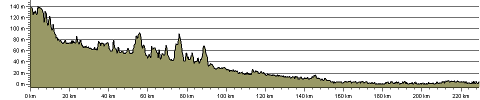
Route Profile:

228.6 km (142.0 miles)
1,253 m (4,111 ft) ascent
144 m (472 ft)  maximum height

This website uses cookies

To comply with EU Directives we are informing you that our website uses cookies for services such as memberships and Google Analytics.

Your data is completely safe and we do not record any personally identifiable information.

Please click the button to acknowledge and approve our use of cookies during your visit.

Learn more about the Cookie Law