Latest News: Read more


Tiger face, named posts in Rutland; double sword logo in CambsHereward Way

Cambridgeshire, Lincolnshire, Norfolk, Northamptonshire, Peterborough, Rutland, Suffolk

177 km / 110 miles
The Way links the Viking Way (at Oakham) with the Peddars Way near to Knettishall Heath. It passes through Stamford, Peterborough and Ely to reach the Brecklands heaths and forests at Brandon and Thetford. There are areas of flat open fenland.

The Torpel Way (11 miles from Peterborough to Stamford and included on OS mapping) provides an alternative option between those two locations - the route is to the north of the Hereward Way.

November 2024: a 2 km stretch of the combined Nene Way and Hereward Way east of Wansford, Cambridgeshire, has been closed since December 2023 due to ‘dualling’ of the main A47. A date has not been specified for re-opening. The closure runs between Sutton Village (TL 095 989) (both LDPs) and Sacrewell Farm (TF 082 001) (Hereward Way). There is to be a new or re-aligned ‘walking and cycling route’ alongside the main road which runs between the old roundabout at TL 095 994 and a new underpass at TL 080 997. See https://nationalhighways.co.uk/our-roads/east/a47-wansford-to-sutton-dualling.

See also E-Routes (E2).


Details:

Waymark: Tiger face, named posts in Rutland; double sword logo in Cambs
Path Type: Paths Marked on OS mapping
Waymark: Tiger face, named posts in Rutland; double sword logo in Cambs
Attributes: Easy
River
Start: SK861088 - Oakham, Rutland
Finish: TL977880 - Harling Road Station, Thetford, Norfolk

Publications, Badges and Certificates:

External download Hereward Way (Ely to Peterborough section)  (Visit Cambridgeshire Fens  - 2012 ) Download

Maps:

You can use the interactive controls to zoom in and out and to move around the map, or click on a path or a marker for more info.(interactive map help)

Show Connected Path Outlines
E Routes
National Trails (England & Wales)
Paths Marked on OS mapping
Other Paths

Show Accommodation
Hostel Accommodation

Contains Ordnance Survey data © Crown copyright and database right 2016.
© OpenStreetMap contributors under Open Database Licence.
Rights of way data from selected Local Authorities.
Large scale digital mapping is provided by John Thorn.
At high zoom levels the route is indicative only.
Purchase Ordnance Survey Maps (path is named on OS maps):
OS Landranger 141, 142, 143, 144
OS Landranger Active 141, 142, 143, 144
OS Explorer 226, 227, 228, 229, 230, 234, 235
OS Explorer Active 226, 227, 228, 229, 230, 234, 235

Accommodation within 5 km of this Path:


From
Path
Along
Path
Hostel Accommodation
< 1 km
25 km

Connected Paths:


Downloads:

Reminder: Material downloaded from this website is for personal or LDWA use only. Commercial use, reproduction, modification of all content is strictly prohibited without prior approval by the LDWA. Please Contact Us if you have any requests.
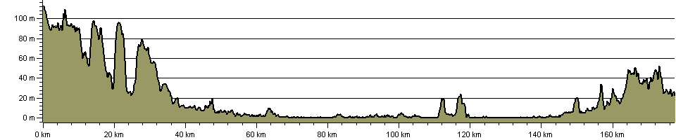

Route Profile:

177.4 km (110.2 miles)
991 m (3,251 ft) ascent
113 m (371 ft)  maximum height

This website uses cookies

To comply with EU Directives we are informing you that our website uses cookies for services such as memberships and Google Analytics.

Your data is completely safe and we do not record any personally identifiable information.

Please click the button to acknowledge and approve our use of cookies during your visit.

Learn more about the Cookie Law