Latest News: Read more


Mersey Valley Timberland Trail

Cheshire

35 km / 22 miles
Passing through Lymm, the route connects with the towpath of the Bridgewater Canal and passes Lymm Dam, Grappenhall Wood, Appleton Dingle, Daresbury Firs, Windmill Hill and Halton Village. It is partly urban, mostly rural, taking in low-lying hills, woodland, parkland, farmland and sections of the Bridgewater Canal. It broadly follows the sandstone edge of the Cheshire Plain or drops to the Mersey valley below it, giving views from both levels. There are links with the Trans Pennine Trail and the Delamere Way. Lewis Carroll was born in Daresbury and Carroll's father was the parson at All Saints Church, which features a stained glass window with characters from the 'Alice' books.

A route description (from Mersey Forest 2007) may be downloaded. It varies in places from that shown on OS mapping, which agrees with the waymarked route 'on the ground'.


Details:

Path Type: Paths Marked on OS mapping
Waymark: Named signs, black stylised tree, white background
Attributes: Easy
Canal
Forest/Woodland
Urban
Literary
Start: SJ702875 - Spud Wood, Oughtrington, Lymm, Cheshire
Finish: SJ507816 - Runcorn Hill, Runcorn, Cheshire
Web Sites: Joe the Cocker's Hikes: Mersey Valley Timberland Trail Backpacking in Britain: Mersey Valley Timberland Trail and Dunham Walking Englishman - Mersey Valley Timberland Trail Mersey Valley Timberland Trail (Walk Highlands Forum) Mersey Valley Timberland Trail, Runcorn, Part 1 The Mersey Valley Timberland Trail, Runcorn Part 2

Publications, Badges and Certificates:

Leaflet - PDF Mersey Forest - Mersey Valley Timberland Trail route pack  (Mersey Forest  - 2007 ) Download File
Route Description - PDF Longer Walking Routes in/through Lymm  (Lymm Parish Council ) Download File

Maps:

You can use the interactive controls to zoom in and out and to move around the map, or click on a path or a marker for more info.(interactive map help)

Show Connected Path Outlines
E Routes
Paths Marked on OS mapping
Other Paths

Contains Ordnance Survey data © Crown copyright and database right 2016.
© OpenStreetMap contributors under Open Database Licence.
Rights of way data from selected Local Authorities.
Large scale digital mapping is provided by John Thorn.
At high zoom levels the route is indicative only.
Purchase Ordnance Survey Maps (path is named on OS maps):
OS Landranger 108, 109
OS Landranger Active 108, 109
OS Explorer 267, 275, 276
OS Explorer Active 267, 275, 276

Connected Paths:


Downloads:

Reminder: Material downloaded from this website is for personal or LDWA use only. Commercial use, reproduction, modification of all content is strictly prohibited without prior approval by the LDWA. Please Contact Us if you have any requests.
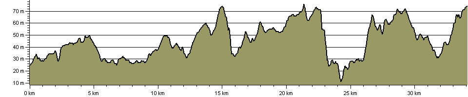

Route Profile:

34.1 km (21.2 miles)
413 m (1,355 ft) ascent
76 m (249 ft)  maximum height

This website uses cookies

To comply with EU Directives we are informing you that our website uses cookies for services such as memberships and Google Analytics.

Your data is completely safe and we do not record any personally identifiable information.

Please click the button to acknowledge and approve our use of cookies during your visit.

Learn more about the Cookie Law