Latest News: Read more


Named green and white discs with oak treesHeart of England Way

Gloucestershire, Staffordshire, Warwickshire, W Midlands

163 km / 101 miles
The Way follows a curving route through gently undulating farmland and lowland heath, woodland and riverside paths. It takes in Cannock Chase, Lichfield and Kingsbury Water Park. It travels through the Arden countryside (see Arden Way) passing close to the village of Meriden (officially the centre of England) through the historic town of Henley-in-Arden, to cross the river Avon at Bidford-on-Avon. From here it heads for the northern aspects of the Cotswolds through Chipping Campden, Swell and Lower Slaughter to Bourton-on-the Water.

The European long distance path E2 (Middleton-in-Teesdale to Dover) leaves the Staffordshire Way and joins the Heart of England Way on Cannock Chase very close to its start. It then follows it all the way to Bourton-on-the-Water where it continues on the Oxfordshire Way.

The Heart of England Way Association provides a volunteer warden service who ensure as far as possible that the route is fully waymarked and walkable. They ask walkers to report any issues to secretary@heartofenglandway.org. Their website is kept up to date with details of historical route changes that have been incorporated into their gpx route file and current temporary diversions which they know about (see https://www.heartofenglandway.org/route_changes).

HS2: The Heart of England Way Association reports that there are ongoing temporary diversions associated with work on HS2. These are described on their website but can vary from time to time without them being notified. However, they report that HS2 are usually good at making the alternative route clear and easy to follow.

See also E-Routes (E2).


Details:

Waymark: Named green and white discs with oak trees
Path Type: Paths Marked on OS mapping
Waymark: Named green and white discs with oak trees
Attributes: Paths marked on OS mapping
Average Gradients
Agricultural land
Canal
Forest/Woodland
Heath
River
Heritage
Start: SJ974211 - Milford, Staffordshire
Finish: SP167208 - Bourton-on-the-Water, Gloucestershire
User Group: Heart of England Way Association Heart of England Way Association
Web Sites: Heart of England Way

Publications, Badges and Certificates:

Guidebook The Heart of England Way : 102 miles of linear walks or 225 miles of 32 linked circular walks  (Sigma Press  - 2018 )
Guidebook The Heart of England Way : Recreational Path Guide  (Aurum Press (an imprint of Quarto)  - 1998 )
Guidebook Heart of England Way  (Walkways  - 2000 )

Maps:

You can use the interactive controls to zoom in and out and to move around the map, or click on a path or a marker for more info.(interactive map help)

Show Connected Path Outlines
E Routes
National Trails (England & Wales)
Paths Marked on OS mapping
Other Paths

Contains Ordnance Survey data © Crown copyright and database right 2016.
© OpenStreetMap contributors under Open Database Licence.
Rights of way data from selected Local Authorities.
Large scale digital mapping is provided by John Thorn.
At high zoom levels the route is indicative only.
Purchase Ordnance Survey Maps (path is named on OS maps):
OS Landranger 127, 128, 139, 140, 150, 151, 163
OS Landranger Active 127, 128, 139, 140, 150, 151, 163
OS Explorer 45, 205, 220, 221, 232, 244, 245
OS Explorer Active 45, 205, 220, 221, 232, 244, 245

Connected Paths:


Downloads:

Reminder: Material downloaded from this website is for personal or LDWA use only. Commercial use, reproduction, modification of all content is strictly prohibited without prior approval by the LDWA. Please Contact Us if you have any requests.

GPX Route File
Heart of England Way GPX Exchange Format Route File
Last Updated 29/03/2026 21:27:12 - Minor route adjustment at Bannams Wood
Login to Download
(Members Only)
MemoryMap Route File
Heart of England Way Memory Map Route File
Last Updated 29/03/2026 21:27:12 - Minor route adjustment at Bannams Wood
Login to Download
(Members Only)
Tracklogs Route File
Heart of Engalnd Way Tracklogs Route file
Last Updated 29/03/2026 21:27:13 - Minor route adjustment at Bannams Wood
Login to Download
(Members Only)

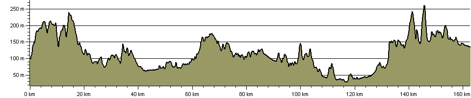
Route Profile:

166.7 km (103.6 miles)
2,199 m (7,215 ft) ascent
265 m (869 ft)  maximum height

This website uses cookies

To comply with EU Directives we are informing you that our website uses cookies for services such as memberships and Google Analytics.

Your data is completely safe and we do not record any personally identifiable information.

Please click the button to acknowledge and approve our use of cookies during your visit.

Learn more about the Cookie Law