Latest News: Read more


Thistle within hexagonSpeyside Way

Highland, Moray

137 km / 85 miles
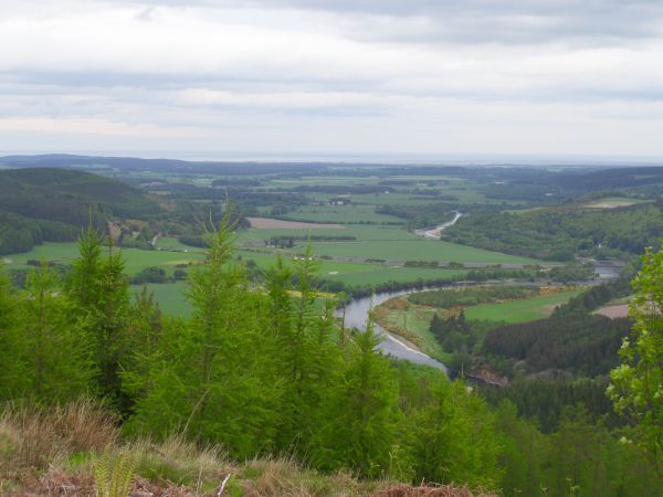
One of the original four Long Distance Routes in Scotland, and now one of the family of Scotland's Great Trails, it traces the course of the River Spey, a renowned salmon river. It links Buckie on the Moray Coast with Aviemore and then on to Newtonmore, and also offers a spur from Cragganmore to Tomintoul (15 miles).

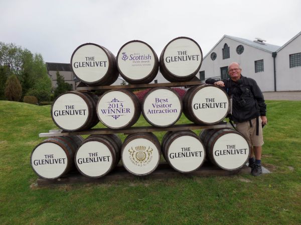
Although the route generally offers easy walking on level ground, much on former railway tracks, before Craigellachie there are climbs to over 900ft on the flanks of Ben Aigan. After Craigellachie it rises gently on the old trackbeds and, after Ballindalloch, a little more steeply in forest to cross the Spey at Cromdale to reach Grantown. Later stages offer views south to the Cairngorms massif and the Lairig Ghru cleft and west to the Monadhliath Mountains. Numerous whisky distilleries are sited along the route. In 2015 the route was extended beyond Aviemore to Kincraig and the recent extension to Newtonmore makes use of the NCN7 cycle route.

June 2024:Due to forestry extraction works the section of the Speyside Way which runs along the edge of Tom an Uird to the north and northeast of Cromdale is closed on weekdays between 3rd of June and mid-September 2024. The signed diversion is along the minor road to the south and east of the forest, an additional 2 miles on the original route. The closure is not in effect at weekends. See https://www.speysideway.co.uk/temporary-diversion-at-tom-an-uird-woods-cromdale-from-3rd-june-to-mid-september-2024


Details:

Waymark: Thistle within hexagon
Path Type: Scotland's Great Trails
Waymark: Thistle within hexagon
Attributes: Scotland's Great Trails
Average Gradients
Former Railway
Coastal
Forest/Woodland
Moorland
River
Start: NJ425656 - Cluny Square, Buckie, Moray
Finish: NN716991 - Newtonmore, Highland
Open Date: 1981
Web Sites: Speyside Way Scotland's Great Trails - Speyside Way Walk Highlands - Speyside Way MorayWays - Speyside Way Undiscovered Scotland - Speyside Way Brian's Walks - Speyside Way [blog] Trailplanner - Speyside Way [blog] Outdoor Scott - Guide to Walking the Speyside Way [blog] A walker's journal - The Speyside Way [blog] Watch Me See - Complete Hiking Guide to the Speyside Way in Scotland [blog] Exploring Scottish Trails - Speyside Way - Part 1 [blog] Speyside Way parts 1-3 [YouTube video] Trailwalker - Speyside Way [blog]

Publications, Badges and Certificates:

Guidebook Walking the Speyside Way : a Scottish great trail : includes the Dava Way and Moray Coast trails  (Cicerone Press  - 2016 )
Guidebook Speyside Way  (Rucksack Readers  - 2021 )
General Interest Book National Trails : 19 long-distance routes through England, Scotland and Wales  (Cicerone Press  - 2015 )
Guidebook A boot up the Speyside Way  (Halsgrove Press  - 2010 )
Certificate Certificate for National Trails  (Long Distance Walkers Association )
General Interest Book Tales from the Big Trails  (Vertebrate Publishing  - 2021 )
Guidebook Moray Way Companion  (Birlinn  - 2022 )

Click to showhide 3 more Publications, Badges and Certificates


Maps:

You can use the interactive controls to zoom in and out and to move around the map, or click on a path or a marker for more info.(interactive map help)

Show Connected Path Outlines
Path Variants
Scotland's Great Trails
Other Paths

Show Accommodation
Hostel Accommodation
Bunk House
Group Accommodation

Contains Ordnance Survey data © Crown copyright and database right 2016.
© OpenStreetMap contributors under Open Database Licence.
Rights of way data from selected Local Authorities.
Large scale digital mapping is provided by John Thorn.
At high zoom levels the route is indicative only.
Purchase Ordnance Survey Maps (path is named on OS maps):
OS Landranger 27, 28, 35, 36
OS Landranger Active 27, 28, 35, 36
OS Explorer 56, 57, 60, 61, 424
OS Explorer Active 56, 57, 60, 61, 424
Other Paper Maps:
Harvey National Trail map
Speyside Way (Harvey Maps - 2021)
Stripmap
Speyside Way: Map & Guide (Footprint Maps - 2019)

Walking Support Providers:

Support Providers
Support Providers
Self-Guided Walking Holidays (Wilderness Scotland)
Support Providers
Self-Guided Walking Holidays (Make Tracks Walking Holidays)
Support Providers
Guided and Self-Guided Walking Holidays (North-West Frontiers Ltd)

Accommodation within 5 km of this Path:


From
Path
Along
Path
Hostel Accommodation
1 km
89 km
Hostel Accommodation
< 1 km
97 km
Bunk House
< 1 km
106 km
Hostel Accommodation
< 1 km
107 km
Hostel Accommodation
2 km
121 km
Group Accommodation
< 1 km
132 km
Group Accommodation
< 1 km
137 km

Click to show 5 more Accommodations


Additional Images:


Connected Paths:


Downloads:

Reminder: Material downloaded from this website is for personal or LDWA use only. Commercial use, reproduction, modification of all content is strictly prohibited without prior approval by the LDWA. Please Contact Us if you have any requests.

GPX Route File
Speyside Way GPX Exchange Format Route File
Last Updated 02/06/2021 22:03:13
Login to Download
(Members Only)
MemoryMap Route File
Speyside Way Memory Map Route File
Last Updated 02/06/2021 22:03:13
Login to Download
(Members Only)
Tracklogs Route File
Speyside Way Tracklogs Route file
Last Updated 02/06/2021 22:03:14
Login to Download
(Members Only)

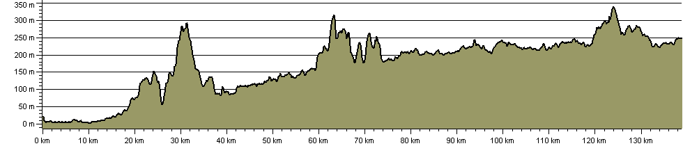
Route Profile:

138.8 km (86.2 miles)
2,254 m (7,395 ft) ascent
341 m (1,119 ft)  maximum height

This website uses cookies

To comply with EU Directives we are informing you that our website uses cookies for services such as memberships and Google Analytics.

Your data is completely safe and we do not record any personally identifiable information.

Please click the button to acknowledge and approve our use of cookies during your visit.

Learn more about the Cookie Law