Latest News: Read more


Rosedale Circuit

N Yorkshire

61 km / 38 miles
Within the North York Moors National Park. Passes through Rosedale, Farndale, Bransdale, Westerdale, Danby Dale, Great Fryup Dale and Glaisdale, which includes many points of natural and historical interest, with moorland tracks and grassy dales. This is a strenuous route with 6.500ft of ascent.

Initially created by the Blackburn Welfare Society Rambling Club from Brough, North Yorkshire. Although the exact beginning date is not known to us, it is likely to be at least 50 years ago. After the club disbanded the walk was picked up and promoted by Kim Peacock of LDWA East Yorkshire Group. However, in 2025, Kim was not able to continue and it looked like the walk would simply be lost. However, members of LDWA Northumbria Group have in 2025/2026 spent time researching and walking the Rosedale Circuit.

The supporting information in the form of route description and GPX file have been revised and rewritten. Being 38 miles with 6,500ft of ascent it is suitable for a strenuous Anytime Challenge to be completed in one continuous walk. It is also suitable to be done over two or even more days depending on your choice. It was originally designed as a two day walk starting and finishing at Rosedale Abbey with the suitable mid-point of Westerdale Village.

If any further questions or for feedback on the walk please email Northumbria LDWA on northumbria.ldwa@org.uk

(July 2026)


Details:

Path Type: Anytime Challenges
Attributes: Anytime Challenges
Challenging
Moorland
Industrial History
Start and Finish: SE724959 - Rosedale Abbey, N Yorkshire
User Group: LDWA Northumbria Group LDWA Northumbria Group
Email: northumbria@ldwa.org.uk

Maps:

You can use the interactive controls to zoom in and out and to move around the map, or click on a path or a marker for more info.(interactive map help)

Show Connected Path Outlines
National Trails (England & Wales)
Other Paths
Anytime Challenges

Show Accommodation
Hostel Accommodation
Camping Barn

Contains Ordnance Survey data © Crown copyright and database right 2016.
© OpenStreetMap contributors under Open Database Licence.
Rights of way data from selected Local Authorities.
Large scale digital mapping is provided by John Thorn.
At high zoom levels the route is indicative only.
Purchase Ordnance Survey Maps:
OS Landranger 94, 100
OS Landranger Active 94, 100
OS Explorer 26, 27
OS Explorer Active 26, 27

Accommodation within 5 km of this Path:


From
Path
Along
Path
Hostel Accommodation
< 1 km
48 km

Additional Images:


Connected Paths:


Downloads:

Reminder: Material downloaded from this website is for personal or LDWA use only. Commercial use, reproduction, modification of all content is strictly prohibited without prior approval by the LDWA. Please Contact Us if you have any requests.

GPX Route File
Rosedale Circuit GPX Exchange Format Route File
Last Updated 12/07/2026 16:18:18 - Northumbria LDWA reviving of route, 2026
Login to Download
(Members Only)

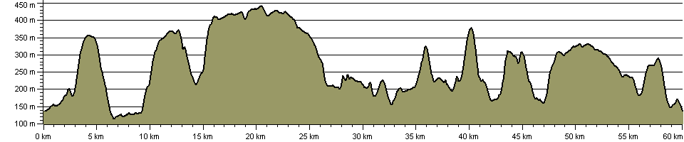
Route Profile:

58.8 km (36.5 miles)
1,931 m (6,335 ft) ascent
442 m (1,450 ft)  maximum height

This website uses cookies

To comply with EU Directives we are informing you that our website uses cookies for services such as memberships and Google Analytics.

Your data is completely safe and we do not record any personally identifiable information.

Please click the button to acknowledge and approve our use of cookies during your visit.

Learn more about the Cookie Law