Latest News: Read more


Railways and Waterways Walk

Buckinghamshire, Hertfordshire, Gtr London, Oxfordshire, W Berkshire

241 km / 150 miles
This circular long distance path starts in rural Oxfordshire then follows the Grand Union Canal, which has a close-knit narrowboat community, into the Chilterns before winding through the suburbs of London. It crosses the playing fields of Eton to join the Thames Path which meanders all the way back to Oxford. The route passes over and under bridges of every kind, through country parks, idyllic villages with thatched cottages, grand estates and historic market towns like Aylesbury, Henley-on-Thames and Wallingford. The lakes, chalk rivers and water meadows are home to a diversity of wildlife, and traditional waterside pubs provide welcome refreshment.

Most stages of the walk start and end at train stations. Those that don’t are served either by the X40 express bus which runs between Reading and Oxford or the X20 between Oxford and Aylesbury. This enables each stage to be completed in a day trip. Intermediate stations and bus stops allow greater flexibility in the distances walked.


Details:

Path Type: Other Paths
Start: SP566074 - Thornhill P&R, Oxford, Oxfordshire
Finish: SP505063 - Oxford Railway Station, Oxfordshire
Open Date: March 2026
Web Sites: Railways and Waterways Walk

Maps:

You can use the interactive controls to zoom in and out and to move around the map, or click on a path or a marker for more info.(interactive map help)

Show Connected Path Outlines
E Routes
National Trails (England & Wales)
Paths Marked on OS mapping
Other Paths
Anytime Challenges

Show Accommodation
Hostel Accommodation

Contains Ordnance Survey data © Crown copyright and database right 2016.
© OpenStreetMap contributors under Open Database Licence.
Rights of way data from selected Local Authorities.
Large scale digital mapping is provided by John Thorn.
At high zoom levels the route is indicative only.
Purchase Ordnance Survey Maps:
OS Landranger 164, 165, 166, 174, 175, 176
OS Landranger Active 164, 165, 166, 174, 175, 176
OS Explorer 159, 160, 170, 171, 172, 180, 181, 182
OS Explorer Active 159, 160, 170, 171, 172, 180, 181, 182

Accommodation within 5 km of this Path:


From
Path
Along
Path
Hostel Accommodation
< 1 km
191 km
Hostel Accommodation
< 1 km
241 km

Connected Paths:


Downloads:

Reminder: Material downloaded from this website is for personal or LDWA use only. Commercial use, reproduction, modification of all content is strictly prohibited without prior approval by the LDWA. Please Contact Us if you have any requests.
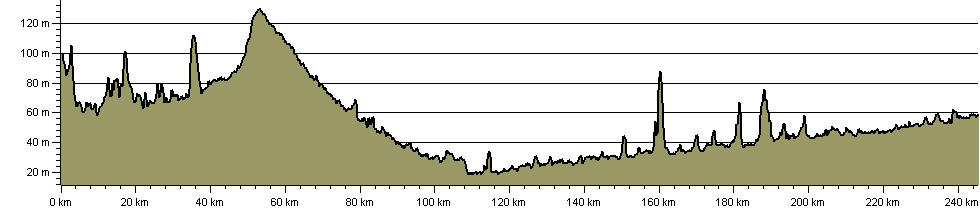

Route Profile:

245.3 km (152.4 miles)
1,401 m (4,596 ft) ascent
130 m (427 ft)  maximum height

This website uses cookies

To comply with EU Directives we are informing you that our website uses cookies for services such as memberships and Google Analytics.

Your data is completely safe and we do not record any personally identifiable information.

Please click the button to acknowledge and approve our use of cookies during your visit.

Learn more about the Cookie Law