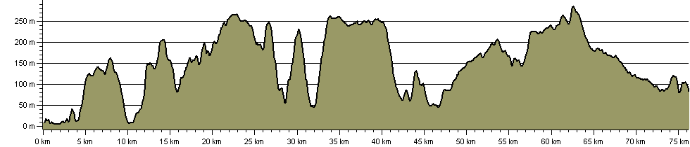
Mendip Way

| Path Type: | Paths Marked on OS mapping |
| Waymark: | White arrow on blue disc with path name |
| Attributes: |
Challenging Downland/Wolds |
| Start: | ST314585 - Uphill, N Somerset |
| Finish: | ST777483 - Frome, Somerset |
| Web Sites: | The Mendip Society Mendip Hills National Landscape - Mendip Way |
| External download |
West Mendip Way Route Directions and Maps - Uphill to Wells
(Mendip Hills National Landscape - 2017 )
 |
| External download |
East Mendip Way Route Directions and Maps - Wells to Frome
(Mendip Hills National Landscape - 2017 )
|
| External download |
Mendip Hills National Landscape - Visitor Guide
(Mendip Hills National Landscape - 2022 )
|
| Guidebook | Uphill to Frome: A Guide to the Mendip Way (David Wright - 2017 ) |
| External download |
Mendip Way - Trail Guide & Map
(Mendip Hills National Landscape - 2023 )
|
You can use the interactive controls to zoom in and out and to move around the map, or click on a path or a marker for more info.(interactive map help)
| OS Landranger | 172, 182, 183 |
| OS Landranger Active | 172, 182, 183 |
| OS Explorer | 141, 142, 153 |
| OS Explorer Active | 141, 142, 153 |
Reminder: Material downloaded from this website is for personal or LDWA use only. Commercial use, reproduction, modification of all content is strictly prohibited without prior approval by the LDWA. Please Contact Us if you have any requests.