Latest News: New NEC Member Read more

Latest News: NEC Vacancies Read more

Latest News: Is it a Record? Read more

Latest News: Lean Project Update Read more

Latest News: LDP Update Read more

Latest News: Digital Platform Update Read more

Latest News: Podcasts Read more

Latest News: Hazel Bound Read more


Llwyber Coedwig Cymru Trail
Bridgend, Glamorgan, Neath Port Talbot, Rhondda Cynon Taff

80 km / 50 miles
An 80km waymarked pilot section of the Llwybr Coedwig Cymru Trail connecting some of the National Forest sites in South Wales. This pilot section of the Llwybr Coedwig Cymru Trail is the first step in its wider development across Wales – an ambitious project to develop a forest Trail that connects our National Forest sites throughout Wales. A sylvan counterpart to the Wales Coast Path. From Porthkerry Park, near Barry, to Pont Walby, close to Glynneath. (Welsh Government).

All of the information about this trail is found on the official website.


Details:

Path Type: Other Paths
Attributes: Forest/Woodland
Start: ST087667 - Porthkerry Country Park, Glamorgan
Finish: SN891066 - Pont Walby, Neath Port Talbot
Open Date: 2026
Web Sites: Llwyber Coedwig Cymru Trail - Welsh Government

Maps:

You can use the interactive controls to zoom in and out and to move around the map, or click on a path or a marker for more info.(interactive map help)

Show Connected Path Outlines
National Trails (England & Wales)
Paths Marked on OS mapping
Other Paths

Show Accommodation
Bunk House

Contains Ordnance Survey data © Crown copyright and database right 2016.
© OpenStreetMap contributors under Open Database Licence.
Rights of way data from selected Local Authorities.
Large scale digital mapping is provided by John Thorn.
At high zoom levels the route is indicative only.
Purchase Ordnance Survey Maps:
OS Landranger 160, 170, 171
OS Landranger Active 160, 170, 171
OS Explorer 12, 151, 166
OS Explorer Active 12, 151, 166

Accommodation within 5 km of this Path:


From
Path
Along
Path
Bunk House
5 km
77 km

Connected Paths:


Downloads:

Reminder: Material downloaded from this website is for personal or LDWA use only. Commercial use, reproduction, modification of all content is strictly prohibited without prior approval by the LDWA. Please Contact Us if you have any requests.


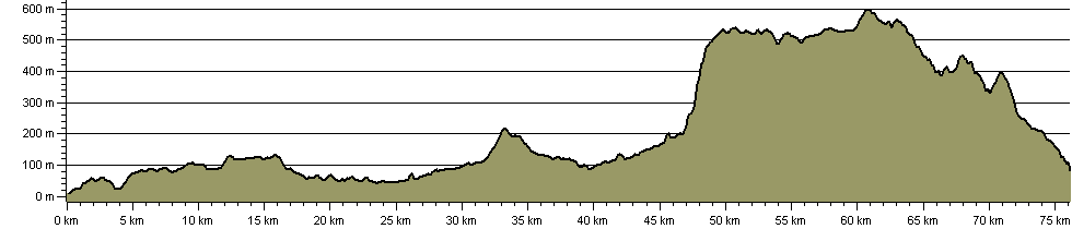
Route Profile:

76.1 km (47.3 miles)
1,638 m (5,374 ft) ascent
596 m (1,955 ft)  maximum height

This website uses cookies

To comply with EU Directives we are informing you that our website uses cookies for services such as memberships and Google Analytics.

Your data is completely safe and we do not record any personally identifiable information.

Please click the button to acknowledge and approve our use of cookies during your visit.

Learn more about the Cookie Law