Latest News: Read more


Letters HW on named green discsHardy Way

Dorset, Wiltshire

349 km / 217 miles
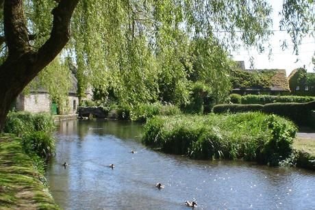
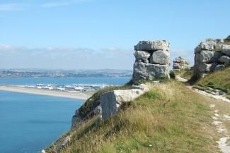
The Hardy Way explores the Wessex of author Thomas Hardy, visiting many Hardy locations beginning at his birthplace near Dorchester. It takes in the Piddle and Frome valleys, an outstanding stretch of coast between Lulworth Cove and the Encombe Valley, to Corfe Castle and Dorchester, ending in Stinsford churchyard where his heart lies buried. The Hardy Way leads through beautiful Dorset and Wiltshire countryside: woodland, high ridgeways, sleepy villages, a variety of farmland, river valleys and dramatic coastal scenery along Dorset's famous Jurassic coast, now a World Heritage Site inscribed by UNESCO for the outstanding universal value of its rocks, fossils and landforms and England's only natural World Heritage Site The route parallels the remarkable eighteen mile pebble Chesil Bank from near Bridport to the Isle of Portland, a gigantic limestone mass near Weymouth.

The creator of the route, Margaret Marande, updated the guidebook in 2015. The book includes details of Hardy's references to the landscapes upon which his books were based. In 1998, at an opening ceremony at Max Gate, the Way became a county footpath and, with the help of the Ramblers Association, was waymarked with distinctive green and white discs. Since that time many walking groups have enjoyed it. Over time one or two route problems made revision necessary and the result was the 2015 edition of the book which retained the essence of the original, but with innovations - Hardy friendly maps and many route amendments. The route was re-waymarked in summer 2015.

The Hardy Way is mainly on footpaths, tracks and bridleways with occasional unavoidable sections on lanes and roads. The Blackmore Vale farmland area in north Dorset can be very muddy in wet weather. Between Beaminster and West Bay through Bridport, the Way is mainly coincident with the waymarked Brit Valley Way (8 miles).


Details:

Waymark: Letters HW on named green discs
Path Type: Paths Marked on OS mapping
Waymark: Letters HW on named green discs
Attributes: Challenging
Coastal
World Heritage Site
Literary
Start: SY728925 - Higher Bockhampton, Nr Dorchester, Dorset
Finish: SY712910 - Stinsford Church, Dorset
Web Sites: Hardy Way BBC news : Hardy Way writer completes cancer walk challenge

Publications, Badges and Certificates:

Guidebook Hardy Way: A 19th Century Pilgrimage  (Margaret Marande  - 2015 )

Maps:

You can use the interactive controls to zoom in and out and to move around the map, or click on a path or a marker for more info.(interactive map help)

Show Connected Path Outlines
E Routes
National Trails (England & Wales)
Paths Marked on OS mapping
Other Paths
Anytime Challenges

Show Accommodation
Hostel Accommodation

Show Points of Interest
Walkers are Welcome

Contains Ordnance Survey data © Crown copyright and database right 2016.
© OpenStreetMap contributors under Open Database Licence.
Rights of way data from selected Local Authorities.
Large scale digital mapping is provided by John Thorn.
At high zoom levels the route is indicative only.
Purchase Ordnance Survey Maps (path is named on OS maps):
OS Landranger 183, 184, 193, 194, 195
OS Landranger Active 183, 184, 193, 194, 195
OS Explorer 15, 116, 117, 118, 129
OS Explorer Active 15, 116, 117, 118, 129

Accommodation within 5 km of this Path:


From
Path
Along
Path
Walkers are Welcome
4 km
173 km
Hostel Accommodation
< 1 km
310 km

Additional Images:


Connected Paths:


Downloads:

Reminder: Material downloaded from this website is for personal or LDWA use only. Commercial use, reproduction, modification of all content is strictly prohibited without prior approval by the LDWA. Please Contact Us if you have any requests.

GPX Route File
Hardy Way GPX Exchange Format Route File
Last Updated 31/07/2024 13:52:21 - Minor changes near Wareham
Login to Download
(Members Only)
MemoryMap Route File
Hardy Way Memory Map Route File
Last Updated 31/07/2024 13:52:21 - Minor changes near Wareham
Login to Download
(Members Only)
Tracklogs Route File
Hardy Way Tracklogs Route File
Last Updated 31/07/2024 13:52:22 - Minor changes near Wareham
Login to Download
(Members Only)

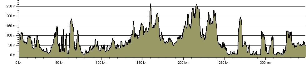
Route Profile:

348.5 km (216.5 miles)
6,171 m (20,246 ft) ascent
268 m (879 ft)  maximum height

This website uses cookies

To comply with EU Directives we are informing you that our website uses cookies for services such as memberships and Google Analytics.

Your data is completely safe and we do not record any personally identifiable information.

Please click the button to acknowledge and approve our use of cookies during your visit.

Learn more about the Cookie Law