Latest News: Read more


Dartmoor Perambulation

Devon

80 km / 50 miles
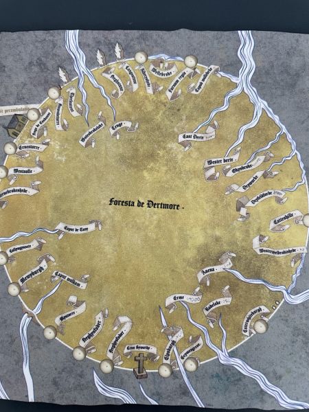
The Royal Forest of Dartmoor was created in 1204. it was only in 1240 that its actual boundary was delineated during the original Perambulation, when twelve knights and their retinues set off to delineate the official boundary. The exact route is something of a mystery as all the scribed copies made over the subsequent centuries have discrepancies and some place names no longer exist.

Over the years the boundary has been disputed, altered and misinterpreted. It makes for a fascinating journey both academically, studying the historical documents, as well as on foot, travelling around Dartmoor in the wake of medieval knights.

This walk aims to guide you around the Forest of Dartmoor as close to the original 1240 Perambulation as possible. It is based on the February 2026 guidebook written by Josephine M Collingwood.

(April 2026)


Strider News - August 2026 (Publication Update)

The Dartmoor Perambulation. A guide to Walking the Medieval Boundary of the Royal Forest of Dartmoor, Josephine M Collingwood, February 2026. 


This is a detailed guidebook for walking Dartmoor’s oldest long-distance walk: the Dartmoor Perambulation.  Packed with colour photographs and OS 1:25,000 maps of every section, the 84km (52 mile) route follows the medieval boundary of Dartmoor Forest, first perambulated in 1240 by twelve knights of the crown.  It is a serious walk over remote moorland, but it also passes through some of the most beautiful areas of Dartmoor, linking them together on a challenging but truly memorable expedition.


  • First full-colour guidebook of the whole Perambulation walk.

  • Route and points of interest presented on OS 1:25,000 map segments for each of the thirty walk sections.

  • Latin transcript, translation and etymological research presented for each waypoint.


Details:

Path Type: Other Paths
Attributes: Challenging
Moorland
Heritage
Start and Finish: SX621938 - Belstone car park, Devon
Web Sites: Dartmoor firing times

Publications, Badges and Certificates:

Guidebook The Dartmoor Perambulation  (Tavicinity Publishing  - Feb 2026 )

Maps:

You can use the interactive controls to zoom in and out and to move around the map, or click on a path or a marker for more info.(interactive map help)

Show Connected Path Outlines
Paths Marked on OS mapping
Other Paths

Show Accommodation
Hostel Accommodation
Group Accommodation

Contains Ordnance Survey data © Crown copyright and database right 2016.
© OpenStreetMap contributors under Open Database Licence.
Rights of way data from selected Local Authorities.
Large scale digital mapping is provided by John Thorn.
At high zoom levels the route is indicative only.
Purchase Ordnance Survey Maps:
OS Landranger 191, 202
OS Landranger Active 191, 202
OS Explorer 20, 28, 113
OS Explorer Active 20, 28, 113

Accommodation within 5 km of this Path:


From
Path
Along
Path
Group Accommodation
1 km
53 km
Hostel Accommodation
< 1 km
54 km
Hostel Accommodation
1 km
77 km
Hostel Accommodation
1 km
77 km

Connected Paths:


Downloads:

Reminder: Material downloaded from this website is for personal or LDWA use only. Commercial use, reproduction, modification of all content is strictly prohibited without prior approval by the LDWA. Please Contact Us if you have any requests.

GPX Route File

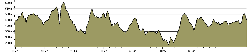
Route Profile:

84.2 km (52.3 miles)
2,234 m (7,329 ft) ascent
613 m (2,011 ft)  maximum height

This website uses cookies

To comply with EU Directives we are informing you that our website uses cookies for services such as memberships and Google Analytics.

Your data is completely safe and we do not record any personally identifiable information.

Please click the button to acknowledge and approve our use of cookies during your visit.

Learn more about the Cookie Law