Every part of England, Scotland and Wales is covered by 403 maps specially designed for walkers, off-road cyclists, horse riders and all involved in outdoor activities. The Active maps are an encapsulated map that is tough, durable and weatherproof. The maps are covered in a protective plastic coating that can be written on, so your favourite routes can be easily highlighted. They are more costly but more durable and may obviate the need for a map case, though they are bulkier and heavier. The Outdoor Leisure map series and the Pathfinder map series have been integrated with the OS Explorer Map series.

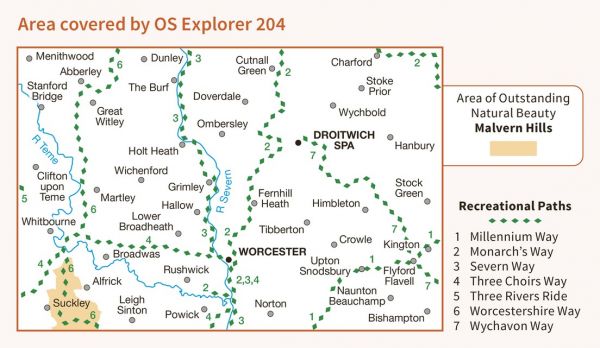
| Abberley Amble | 32 km / 20 miles |
| Black Pear Marathon | 39 km / 24 miles |
| Bromsgrove Circular Walk | 48 km / 30 miles |
| Cotswold and Malvern Line Rail Trail | 66 km / 41 miles |
| Geopark Way | 175 km / 109 miles |
| Malvern Link | 58 km / 36 miles |
| Millennium Way (Warks) | 161 km / 100 miles |
| Monarch's Way | 948 km / 589 miles |
| Robert's Romp | 45 km / 28 miles |
| Sabrina Way | 327 km / 203 miles |
| Saltway Line Rail Trail | 26 km / 16 miles |
| Severn Way | 360 km / 224 miles |
| St Kenelm's Way | 80 km / 50 miles |
| Teme Valley Walk | 150 km / 93 miles |
| Teme Valley Way | 154 km / 96 miles |
| Three Choirs Way | 161 km / 100 miles |
| Via Beata | 731 km / 454 miles |
| Worcester and Birmingham Canal Walk | 50 km / 31 miles |
| Worcestershire Way | 50 km / 31 miles |
| Wychavon Marathon | 42 km / 26 miles |
| Wychavon Way | 64 km / 40 miles |
| Wye to the Thames | 192 km / 119 miles |
| Wyre Valley Line Rail Trail | 48 km / 30 miles |
