

A note on ascent
After a few 'flat' years, you can see that the Jurassic 100 route is a return to a hilly route, comparable to previous events in the area (e.g. 2004 Exmoor, 2016 Dorset, 2013 Camel-Teign) events.
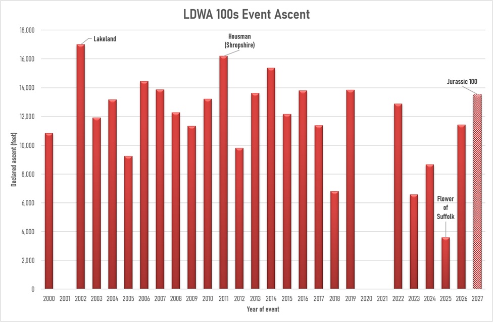
*No events held in 2001 (Foot and Mouth disease outbreak) and 2020 (Covid-19 pandemic). 2021 was the Virtual Sir Fynwy where ascent depended on route chosen.
**Lakeland data estimated.
***J100 route estimate, not yet finalised
East Devon and West Dorset is an undulating area, which is part of its charm - lots of spectacular views along the coast and over the rural inland. There are no very big hills, as might be found further north in the UK, but the ascents and descents are short and steep. This does mean exertion is less prolonged, with lots of opportunities to recover, but the ascent does add up overall. The highest point is reached before CP1 (256m), at Lamberts Castle Hill Fort, although the same height is almost reached at Farway Common (248m, on Leg L), before the long descent back to the River Axe.
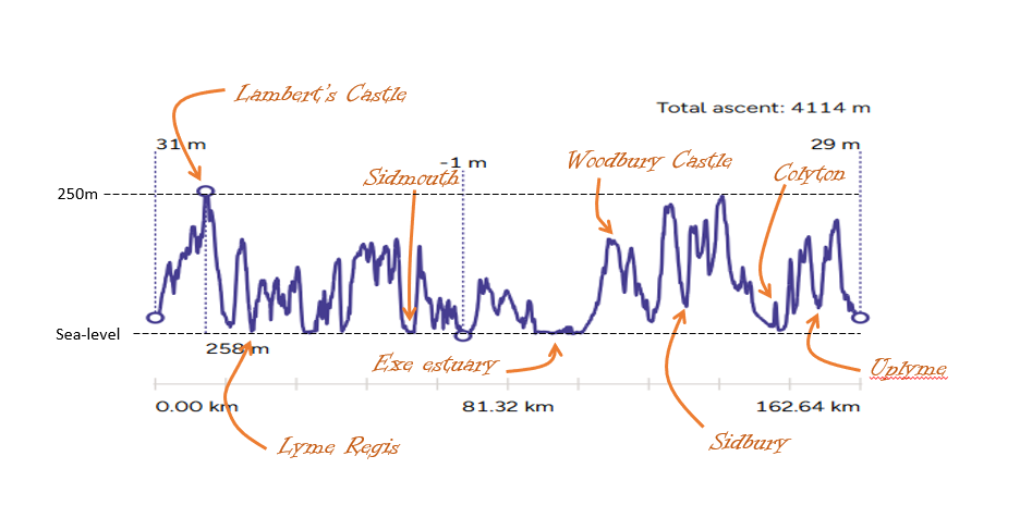
Please be assured that much thought and care has been taken to minimise unnecessary climbs and drops - for instance, circumnavigating Weston and Salcombe mouths to avoid descending all the way to the beach, and staying high on the cliff between Beer and Branscombe (leg D), rather than using the precipitous 'Stairway to Heaven' and the tiring shingle beach. The last leg has been routed to avoid late climbing where possible. The hills remaining are therefore an integral part of the route, and will (fingers crossed) provide you will wonderful views and a solid challenge.
What does this mean for finish rate and finish times?
What is interesting, looking at the data from the last quarter of a century of 100s, is noting just how poor the correlation really is between ascent total and finish completion rate, and average finish times. As you can see from the labelled spots, the very hot or wet years (thankyou, Kent and South Wales!) have resulted in some slower average finish times and lower completion rates, whilst the Lakeland event in 2002 was fairly fast given the amount of climb, although less than 2/3 of entrants finished. This data suggests that even with a larger total ascent, average finish times can be in the 'usual' range, as long as the conditions are clement.
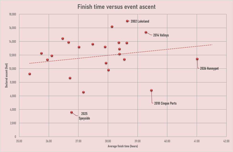
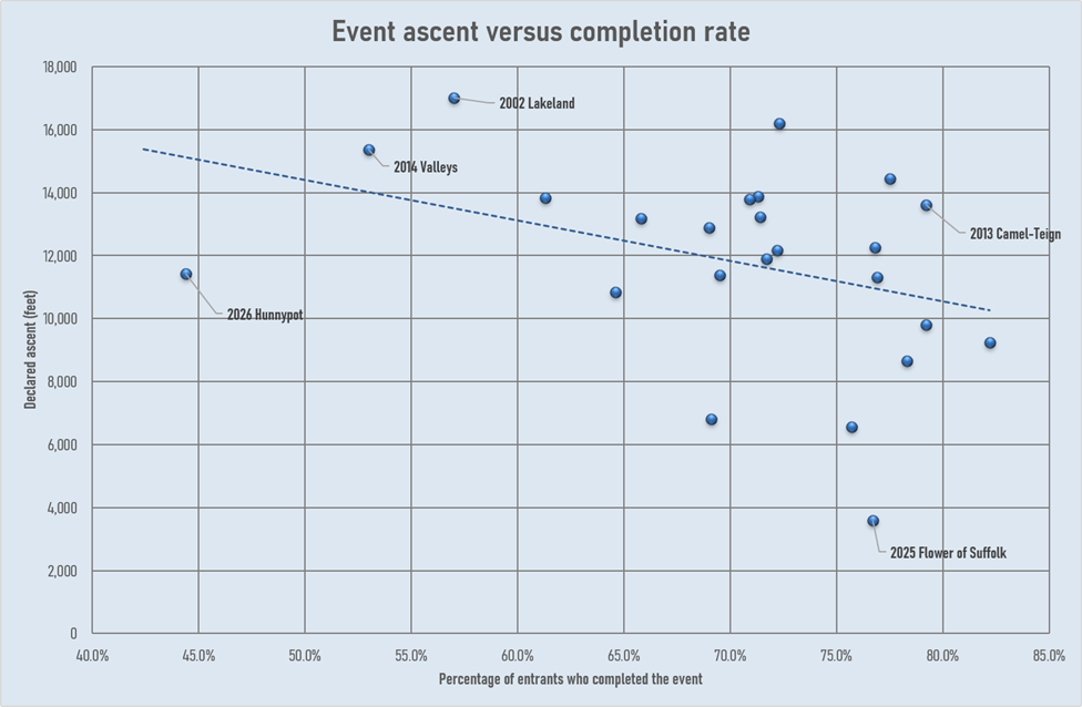
*Lakeland data estimated. Data refers to main event finishers only.
The message is - the J100 will be hilly, and those hills are steep, but in line with previous local 100s. You will need to train for and be prepared for climbs. We will hope (and pray and dance to all the gods) that the weather is kind as this appears to be a very important factor in participant completion rate and average time taken - pandemics (human or animal) aside. Advice given to the author by a running friend from Yorkshire who completed a running race (along the SW Coast Path) was to train by climbing stairs or use a stair climber if you don't have access to any steep hills or cliff paths locally. Another option would be to visit the area ahead of time and recce some of the steeper sections of the route!
---------------------------------------- With very grateful thanks to Keith Warman, 100s Recorder, for compiling and sharing this data --------------------------------------------------------







