

Geology - the Jurassic Coast
Anyone who spends any time walking in the British landscape understands that attractive landscapes depend on geological features and formations which govern why hills, cliffs, rivers and even towns are where they are. The J100 takes in the Jurassic Coast, declared a World Heritage Site in 2001 due to the spectactular exposure of its underlying geology. The cliffs of the Site (running from Orcombe Point in Exmouth, to Old Harry Rocks at Purbeck in Dorset) form a unique and nearly continuous record of 265 million years of rock deposition. They are celebrated at the Geoneedle, at Orcombe Point at Exmouth, which you will visit on the J100.
I hope here to provide a taster of the general geology of the area, and some of the more interesting features that can be seen during the J100. I include some sources of further information at the end for those who wish to read further or explore more extensively.
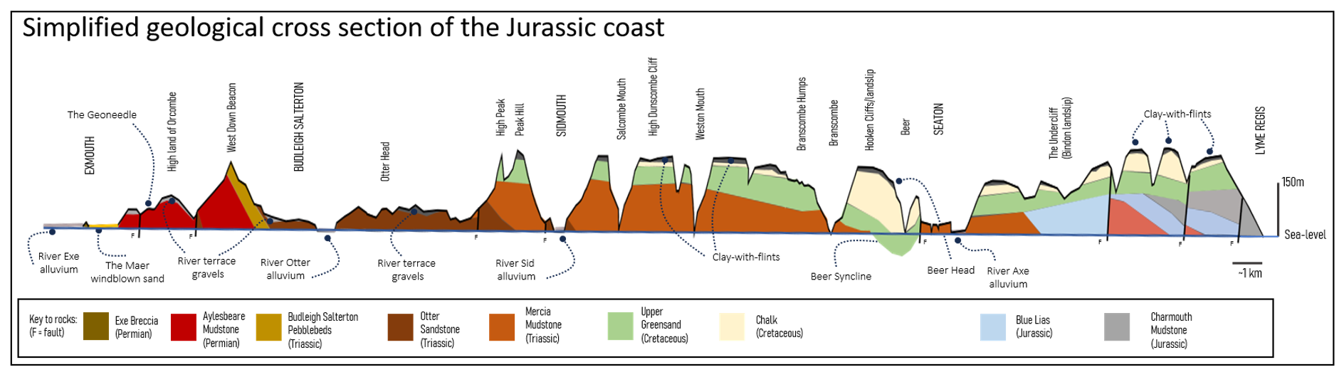
Above: Schematic geological cross-section through the Jurassic coast, adapted from the book: ‘Geology of the Jurassic Coast: The Red Coast Revealed - Exmouth to Lyme Regis’ by Richard Edwards. Please not that this section is VERY horizontally compressed in scale!!
Due to the gentle easterly tilting of the rocks, we will walk over bedrock that becomes progressively older as the J100 travels from west to east from Charmouth to Exmouth. This can be seen visually in the colours and textures of the cliffs, and in the landforms which have developed as a result of the geology. These rocks were laid down in a variety of environments, in eras where continent shapes, coastlines and climate were different to ours.
It is worth remembering that the sedimentary rock record only records sediment that is deposited (usually in water) and then preserved through burial, and so for periods of time if rocks are thrust up above water-level due to tectonic movements, they are normally eroded away and little record of that time exists in the geology. If later deposition starts again on top of the eroded surface (due to continental sinking, or further tectonic movements) the new sediments may be deposited on much older rocks, sometimes at an angle relative to the overlying ‘flat’ sediment – the ‘gap’ between these is called an unconformity and represents a period of missing rock record.
Whilst our walk travels from east to west, young to old, it is easier to describe the rocks from old to young.
The oldest rocks of the Jurassic Coast (Permian 265million years to 250 million years before present)
The Exe Breccia can be seen in the low cliffs behind the seafront in Exmouth – it is a coarse, red rock with sharp-edged fragments of jumbled sandstone. These beds were formed by huge alluvial fans (ancient braided river systems) which drained down from uplands that existed to the west at the time.
Easier to spot on our walk is the Aylesbeare mudstone, seen in the cliffs as you come down the steep walkway at Orcombe Point before Exmouth. This was laid down by winds in a huge periodically dry playa lake (an inland lake in a desert environment), so is unusual as a form of sedimentary rock not deposited by or under water.
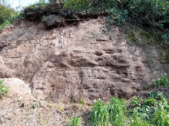
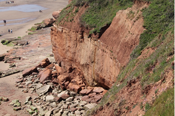
Photos: LEFT Exe Breccia seen in the low cliffs behind the Maer on Exmouth seafront; RIGHT Aylesbeare mudstone at Orcombe Point
Red rocks (Triassic 250 to 200 million years before present)
The Jurassic coast is somewhat of a misnomer, since much of the site is actually Triassic in age. They are notably red in colour, like the Permian rocks, but unlike the younger Jurassic and Cretaceous rocks which are paler. The first sequence is the fascinating Budleigh Salterton Pebblebeds, which were deposited by enormous gravel rivers, flowing from south to north. The pebbles themselves are a very hard sandstone called quartzite, eroded from much older rocks, so whilst some of them contain fossils (such as brachiopods, bivalves and trilobites), these date to the original older source rocks. The pebblebeds can be seen in the cliffs west of Budleigh Salterton (not easily from the J100 route itself) but you will experience the them at first hand walking over Woodbury Common, where the soil is thin enough for the pebbles ('popples') to be at the surface. The shingle ridge at Budleigh is formed from eroded out pebbles – a third sedimentary home for these rocks.
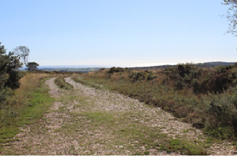
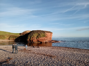
Photos: LEFT The heathland that covers the pebblebeds where they are exposed at the surface (Woodbury Common, looking south); RIGHT: Otter Head (made of Otter Sandstone, see below) with the shingle beach of Budleigh Salterton in the foreground where the pebbles have collected (looking eastwards).
Next, the Otter sandstone is a red sandstone formation, formed by windblown dunes followed by sandy arid river systems, again flowing south to north. It is seen at close hand along the walkway between the two beaches at Sidmouth ('Jacob's Ladder'), where a fault has hoisted the Otter sandstone out of the depths (faults described further below). The Otter sandstone underlies Otter Head, the cliffs between High Peak (east of Sidmouth) and the mouth of the River Otter. The Otter sandstone is of international importance for mid-Triassic fossil finds: reptiles, arthropods, amphibians, fish and an odd creature named the rhyncosaur (‘beaked lizards’ – an excellent specimen found at Ladram Bay is on view at the museum in Exeter). Sometimes you can see long vertical hard structures crossing the bedding structures which represent the calcified remains of fossil plant roots.
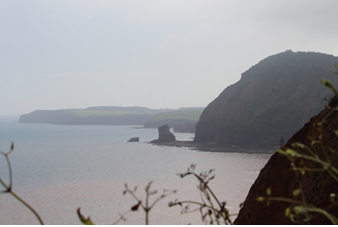
Photo: Looking west from Sidmouth past Peak Hill to Otter Head (distance) - the J100 will walk most of this cliff section
Finally, youngest in the Triassic series are the Mercia mudstone and the Penarth Group. The former was deposited in a quiet inland lake, occasionally drying up completely (so forming sedimentary gaps) and the latter in a brackish environment. There are some rare brachiopod fossils in the Mercia mudstone, which can be seen in the cliffs west of Sidmouth towards Ladram Bay (and in the sloped top of the sea-stacks). Due to the tilt of the rocks, the lower rocks between Branscombe and Sidmouth are also this same Mercia Mudstone. The Penarth Group shows a move towards more marine conditions and consists of black mudstones and isn't easily seen on our route.
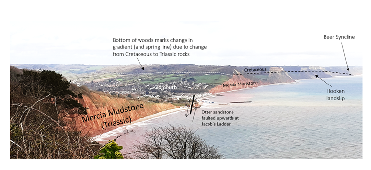
Photo (annotated): views east along the coast past Sidmouth, showing red Triassic cliffs, progressively more overlain by the white Cretaceous greensand and chalk. You can also see the classic scenery of wooded hilltops over more rolling farmland of East Devon, described further below, which reflects the underlying geology.
The famous rocks (Jurassic 200-145 million years before present)
There is a good reason why these rocks are famous, and that is due to the impressive fossils found in rocks after regular cliff-falls. Even very amateur fossil hunters will be able to find ammonites with patience and tools. The most famous local fossil hunter, Mary Anning (1799-1847) started collecting fossils with her family as a child and took over the ‘family business’ at the age of 11. She found the first scientifically-described ichthyosaur, the first complete plesiosaur and countless other fossils, and her work brought many noted scientists to the area.
There are two rock formations of note: the Blue Lias and the Charmouth Mudstone. The older Blue Lias (which is whiteish in colour), was laid down in a shallow, life-rich sea which extended over much of Britain at the time. It can be seen in the cliffs of the Undercliff area and east towards Lyme Regis and contains ammonites and the famous marine dinosaurs. The younger Charmouth Mudstone, contains birds, dinosaurs and abundant ammonites which are found after cliff-falls (a dangerous business as falls can happen at any time, and deaths are not uncommon).
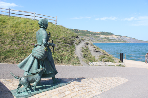
Photos: Mary Anning, striding east from Lyme Regis towards Charmouth - you can see the Charmouth mudstone in the distant cliffs.
More white rocks (Cretaceous, 112-86 million years before present)
As you can see from the gap in the dates, there is a significant unconformity in this area between the Jurassic limestones and the Cretaceous rocks which are whiteish yellow sand and limestones. These were laid down over the older Triassic and Jurassic rocks, which had been tilted and eroded in the interim, so they can be seen ‘capping’ the red cliffs along the more easterly part of the J100 (shown in the geological cross section picture, and the Sidmouth view above).
There are three formations to note: firstly, the Gault, a slippy and patchy muddy clay laid down in a shallow sea which invaded much of South-West England, that cannot be seen in the cliffs, but is thought to form the weak layer that has enabled the landslips such as the Hooken landslip to fail (west of Beer head and not entered during the J100 due to the exceedingly steep terrain - we will stay on the cliffs above). Secondly, the Upper Greensand, formed by a shallow sandy sea, full of fossil marine bivalves, gastropods and echinoids. This formation can be seen broken and jumbled up at the Hooken landslip, and above your heads in the Undercliff section. Finally we have the Chalk, the same chalk seen widely across southern England, and forming the famous white cliffs of Dover. You will be walking over the most westerly chalk headland in England, at Beer Point. It is also found in the upper cliffs between Beer and Branscombe and was worked; leaving behind the ‘Dunscombe Humps’ which you will walk through. The chalk was laid down on a deep sea floor and is made largely of fossils which floated and settled making a muddy calcareous rock – microscopic algal coccoliths, but also other marine fossils, such as ammonites, brachiopods, gastropods and sponges.
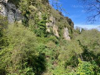
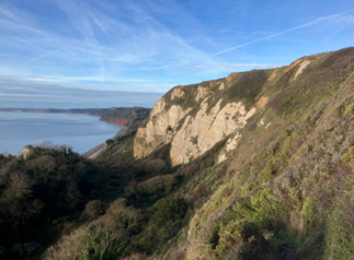
Photo: LEFT: The Cretaceous rocks seen from within the Undercliff Section between Lyme Regis and Axmouth (looking east) - the underlying Jurassic rocks in this section are best seen from a boat! RIGHT: Looking west along the coast, with the Cretaceous rocks overlying the Hooken landslip (between Beer Head and Branscombe) seen in the foreground.
Tertiary and Recent deposits (Quaternary 1.8 million years to present)
Another unconformity is followed by the most recent deposits – these are the rocks and landcover that are found on top of the ‘hard geology’ below. They are made up of reworked, eroded older formations and have been laid down in environments that cycled rapidly between cold (glacial) and less cold (interglacial) periods. Often this material is not seen, hidden by soil and vegetation. A slightly older (Tertiary) formation called (excitingly!) ‘clay-with-flints’ can be seen at the top of the Dunscombe Cliffs, and forms the hard top of the hills between Salcome Regis and Beer, and between Seaton and Lyme Regis). The eroded out flints can be found in the river beds, and form a lot of the hard pebbles at the shingle beaches east of Sidmouth.
Other more recent deposits form very visible and interesting landforms, where we move from the realm of geology to geography! On the J100, there are some wonderful examples of shingle beach and ridge deposits (e.g. Seaton and Budleigh beaches), as well as saltmarshes behind these in the Otter and Axe estuaries (see below). River terrace deposits formed by the rivers in previous times and subsequently eroded out, form terraces and low hills in the Otter Valley. You can see windblown sand (the dunes at the Maer nature area behind the seafront at Exmouth) and chaotic landslips (the ‘Undercliff’ west of Lyme Regis and modern cliff-falls that occur every winter – let’s hope the J100 route doesn’t need to be too altered by the coming winter!) The wonderful sand spit at Dawlish Warren, seen very close to Exmouth on the other side of the river, is a classic example formed by longshore drift of eroded sandy material. When the A30 at Honiton was built, fossil remains of hippopotamous, elephant, giant ox and red deer were found from the Quaternary period; it is also possible to find human-made hand-axes, or mammoth teeth, but will require luck and patience!
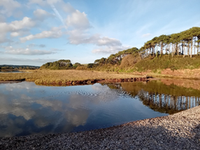
Photo: Looking north (inland) from the shingle bar at Budleigh Salterton, with the saltmarshes in the Otter estuary behind.
Faults and bends
Tectonic movements have not only caused the overall tilt of the rocks from west to east, giving us our ‘walk through time’, they have given us some other interesting features which affect both landscape and its human uses. There are faults, which run mainly north to south, where tectonic movement has thrown older, deeper rocks, up against the younger rocks; if these older rocks are more resistant to weathering, it can result in steep cliffs, constraining the path of rivers. Good examples are the north-south faults at the eastern side of the Otter valley, resulting in a steep red cliff-side (seen in the picture just above). Jacob’s ladder in Sidmouth and Seaton Hole are other good examples. There is also a significant geological feature known as the Beer Syncline, where the rocks at Beer have been bent into a shallow U-shape; here the thick bedrock of Cretaceous Beer Stone has been quarried for at least 2000 years for use in buildings far and wide.
Landscapes related to the underlying geology
Inland from the coast, the land forms essentially a large plateau, made slightly irregular by faults, and cut through by rivers and streams. The Cretaceous rocks are very hard and so form steep-sided slopes, often wooded. There is a change in slope below this formation, where the softer, more weathered red Triassic rocks form gentler rolling farmland which gives East Devon its distinctive landscape. Springs emerge from below the upper Cretaceous rocks, and cut steep-sided streams (known locally as goyles), such as that seen alongside the J100 route in Harpford Woods. One interesting feature is that the rapid retreat of the cliffs due to marine erosion means that the goyles at Weston and Salcombe have not been able cut down fast enough, and so form ‘hanging valleys’. Walking down to the beaches here and back up again is tough work, and so the J100 route takes us inland to save your legs!
Further information
I hope this has provided a taster of the geological pleasures of the area; if you find the subject interesting, most of the small local museums have good specimens, with excellent fossil and finds shown in Exeter and Lyme Regis. I highly recommend the small but well-explained and illustrated guide ‘Geology of the Jurassic Coast: The Red Coast Revealed - Exmouth to Lyme Regis’ by Richard Edwards, and 'The Official Guide to the Jurassic Coast: A Walk through Time' both published by www.coastalpublishing.co.uk.
If you do go fossil-hunting or want to take a closer look at the cliffs, take advice from locals, and follow the Fossil Collecting Code of Conduct as well as staying safe.







