
Latest News: Read more


Solihull Way

Warwickshire, W Midlands

34 km / 21 miles
From south to north around the eastern side of Solihull the route uses farmland, open spaces, nature reserves and parks as much as possible.

The route also briefly visits Solihull centre, skirts the edge of Birmingham International Airport and runs near the M6 in places.

Due to numerous path closures a long-term recommended diversion is in place which is likely to be made permanent between the canal at Catherine-de-Barnes (SP 18030 80395) and Damson Parkway near Land Rover (SP 16603 82198). At Catherine-de-Barnes continue west along the canal to the next road bridge (Damson Parkway) then leave the canal and take the footpath west into the park. Follow the surfaced path north then west through the park and continue onto Damson Lane. Follow Damson Lane north to re-join the main route at the lane just north of the roundabout.

The original route from west of Blythe Valley Business Park (SP13243 74893) to the A34 just west of the M42 (SP 14454 75900) involves walking alongside the busy A34 and round the A34/M42 roundabout. A long-term plan to officially change this part of the route is likely to take place in the near future and is already well established. It is a far preferable route in all respects, using purpose made footpaths and boardwalks with very little road walking, although the original route is still viable for those who wish to follow it. The recommended alternative follows a path north east along a line of ponds and a wood to the Business Park access road near the A34/M42 roundabout, then north on a surfaced path to a pelican crossing over the A34.


Strider News - December 2025 (Route Diversions)


Details:

Path Type: Other Paths
Attributes: Easy
Urban
Start: SP117739 - Earlswood Crossroads, Warwickshire
Finish: SP141899 - Castle Bromwich Hall Gardens, W Midlands

Publications, Badges and Certificates:

External download Solihull Way  (Solihull Metropoliton Borough Council  - 1997 & 1999 ) Download

Maps:

You can use the interactive controls to zoom in and out and to move around the map, or click on a path or a marker for more info.(interactive map help)

Show Connected Path Outlines
Paths Marked on OS mapping
Other Paths

Contains Ordnance Survey data © Crown copyright and database right 2016.
© OpenStreetMap contributors under Open Database Licence.
Rights of way data from selected Local Authorities.
Large scale digital mapping is provided by John Thorn.
At high zoom levels the route is indicative only.
Purchase Ordnance Survey Maps:
OS Landranger 139
OS Landranger Active 139
OS Explorer 220, 232
OS Explorer Active 220, 232

Connected Paths:


Downloads:

Reminder: Material downloaded from this website is for personal or LDWA use only. Commercial use, reproduction, modification of all content is strictly prohibited without prior approval by the LDWA. Please Contact Us if you have any requests.

GPX Route File
Solihull Way GPX Exchange Format Route File
Last Updated 09/02/2021 17:18:42
Login to Download
(Members Only)
MemoryMap Route File
Solihull Way Memory Map Route File
Last Updated 09/02/2021 17:18:42
Login to Download
(Members Only)
Tracklogs Route File
Solihull Way Tracklogs Route file
Last Updated 09/02/2021 17:18:42
Login to Download
(Members Only)

Route Profile:

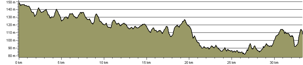
33.3 km (20.7 miles)
244 m (801 ft) ascent
149 m (489 ft)  maximum height

This website uses cookies

To comply with EU Directives we are informing you that our website uses cookies for services such as memberships and Google Analytics.

Your data is completely safe and we do not record any personally identifiable information.

Please click the button to acknowledge and approve our use of cookies during your visit.

Learn more about the Cookie Law