Latest News: Read more


Great Glen Way Invergarry Link

Highland

13 km / 8 miles
The Invergarry Link offers an alternative to the main Great Glen Way route between Kilfinnan (near Laggan Locks) and Aberchalder. The path winds along forest tracks on the western side of Loch Oich, passing through the village of Invergarry. It gives great views of Loch Oich, Glengarry, Ben Tee and the Loch Lochy Munros. The Link is more varied in terms of path surface and gradient than the main path on the other side of Loch Oich and is waymarked and marked on maps.

UPDATE December 2023: The original Great Glen Way route along the eastern side of Loch Oich is closed until December 2024 for forestry work. The diversion uses the Invergarry Link. For more details see
https://www.highland.gov.uk/greatglenway/news/article/31/ggw_route_diversion_along_loch_oich_from_the_start_of_december_2022_to_december_2024


Details:

Path Type: Scotland's Great Trails
Waymark: Thistle within hexagon on blue posts
Attributes: Scotland's Great Trails
Paths marked on OS mapping
Challenging
Cycle Route
Forest/Woodland
Lake/Reservoir/Loch
Start: NN282963 - West of Laggan Locks, Highland
Finish: NH339035 - Oich Bridge, Aberchalder, Highland
Open Date: 2014
Web Sites: Great Glen Way - Invergarry Link Highland Council - Great Glen Way Independent Hostels UK - Great Glen Way Accommodation Scotland's Great Trails - Great Glen Way Outdoor Scott - Guide to the Great Glen Way [blog] Walk Highlands - Great Glen Way: Invergarry Link Jasmine Goes for a Walk - Great Glen Way

Publications, Badges and Certificates:

Guidebook Great Glen Way  (Rucksack Readers  - 2024 )
Guidebook Great Glen Way: Fort William to Inverness  (Trailblazer  - 2021 )
Guidebook Great Glen Way: Fort William to Inverness two-way trail guide  (Cicerone Press  - 2025 )

Maps:

You can use the interactive controls to zoom in and out and to move around the map, or click on a path or a marker for more info.(interactive map help)

Show Connected Path Outlines
Path Variant of
Other Paths

Show Accommodation
Hostel Accommodation

Contains Ordnance Survey data © Crown copyright and database right 2016.
© OpenStreetMap contributors under Open Database Licence.
Rights of way data from selected Local Authorities.
Large scale digital mapping is provided by John Thorn.
At high zoom levels the route is indicative only.
Purchase Ordnance Survey Maps (path is named on OS maps):
OS Landranger 34
OS Landranger Active 34
OS Explorer 400, 415
OS Explorer Active 400, 415
Other Paper Maps:
Map (Other)

Accommodation within 5 km of this Path:


From
Path
Along
Path
Hostel Accommodation
< 1 km
1 km
Hostel Accommodation
< 1 km
7 km

Connected Paths:


Downloads:

Reminder: Material downloaded from this website is for personal or LDWA use only. Commercial use, reproduction, modification of all content is strictly prohibited without prior approval by the LDWA. Please Contact Us if you have any requests.

GPX Route File
MemoryMap Route File
Tracklogs Route File

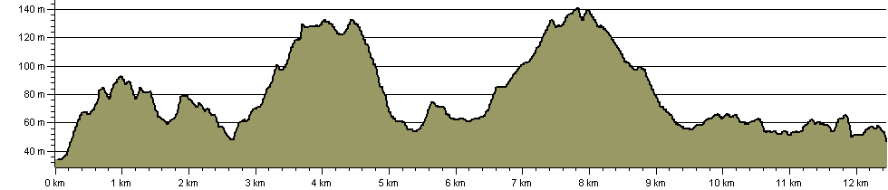
Route Profile:

13.1 km (8.1 miles)
405 m (1,329 ft) ascent
140 m (459 ft)  maximum height

This website uses cookies

To comply with EU Directives we are informing you that our website uses cookies for services such as memberships and Google Analytics.

Your data is completely safe and we do not record any personally identifiable information.

Please click the button to acknowledge and approve our use of cookies during your visit.

Learn more about the Cookie Law