Latest News: Read more


Named standard waymarksCross Bucks Way

Bedfordshire, Buckinghamshire

38 km / 24 miles
A route mainly through agricultural land linking with the Oxfordshire Way at Stratton Audley, the North Bucks Way at Addington, the Swan's Way at Swanbourne and the Greensand Ridge Walk at Old Linslade.


JUNE 2026 Note from members of LDWA BBN Group

Members of LDWA BBN Group walked the section from Winslow to Stratton Audley, which passes through Twyford. We were going along nicely till we passed through Hillesden and came to the section to enter Twyford. There we encountered the HS2 works.

We tried every footpath leading to Twyford but all were blocked with no suggested diversion route. We looked at the roads but they were also closed. We could not find any route to take us into Twyford, or link back up with the trail further along. We managed to get back to the car by doing a long walk on a busy road - about 6 miles longer than we'd planned to walk.

When we walked the CBW last year there was a diversion route which only added a mile to the walk. At that time, we were told that the stretch would be completed by the end of 2025. We provided this diversion in the LDP description and GPX but at the moment this alternate route is no longer available and the CBW is effectively closed to the east of Twyford.

We will keep our eye on the situation around Twyford and we will let you know as soon as the paths reopen.


Details:

Waymark: Named standard waymarks
Path Type: Other Paths
Waymark: Named standard waymarks
Attributes: Easy
Start: SP608261 - Stratton Audley, Buckinghamshire
Finish: SP913263 - Linslade, Bedfordshire
User Group: LDWA Beds, Bucks and Northants LDWA Beds, Bucks and Northants
Web Sites: Pete's Walks Blog - Cross Bucks Way [blog] Walking Englishman - Cross Bucks Way Rights of way improvement plan 2020 to 2030 (Buckinghamshire Council) Walking the Cross Bucks Way: A Connector Trail Through Rural Buckinghamshire

Maps:

You can use the interactive controls to zoom in and out and to move around the map, or click on a path or a marker for more info.(interactive map help)

Show Connected Path Outlines
Paths Marked on OS mapping
Other Paths

Contains Ordnance Survey data © Crown copyright and database right 2016.
© OpenStreetMap contributors under Open Database Licence.
Rights of way data from selected Local Authorities.
Large scale digital mapping is provided by John Thorn.
At high zoom levels the route is indicative only.
Purchase Ordnance Survey Maps:
OS Landranger 164, 165
OS Landranger Active 164, 165
OS Explorer 191, 192
OS Explorer Active 191, 192

Connected Paths:


Downloads:

Reminder: Material downloaded from this website is for personal or LDWA use only. Commercial use, reproduction, modification of all content is strictly prohibited without prior approval by the LDWA. Please Contact Us if you have any requests.

GPX Route File
Cross Bucks Way GPX Exchange Format Route File
Last Updated 22/09/2025 11:57:37 - Revised after route recce by BBN Group
Login to Download
(Members Only)
MemoryMap Route File
Cross Bucks Way Memory Map Route File
Last Updated 22/09/2025 11:57:37 - Revised after route recce by BBN Group
Login to Download
(Members Only)
Route Desc (MS Word)
Tracklogs Route File
Cross Bucks Way Tracklogs Route file
Last Updated 22/09/2025 11:57:37 - Revised after route recce by BBN Group
Login to Download
(Members Only)

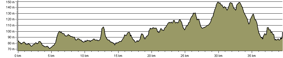
Route Profile:

41.3 km (25.7 miles)
355 m (1,165 ft) ascent
149 m (489 ft)  maximum height

This website uses cookies

To comply with EU Directives we are informing you that our website uses cookies for services such as memberships and Google Analytics.

Your data is completely safe and we do not record any personally identifiable information.

Please click the button to acknowledge and approve our use of cookies during your visit.

Learn more about the Cookie Law