Latest News: Read more


England Coast Path

Various

4498 km / 2795 miles
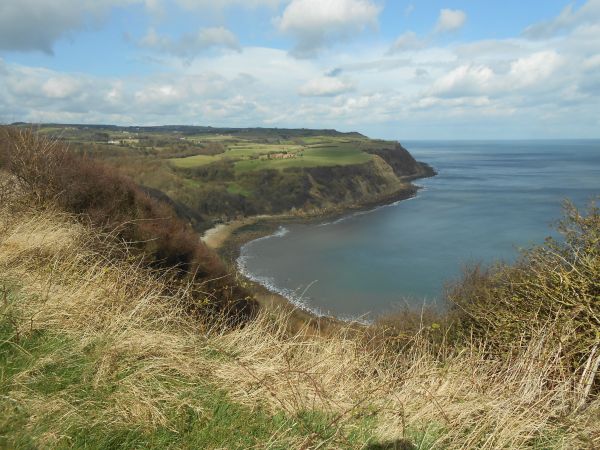
The England Coast Path is a major project with committed Government funding of some £5 milion to define a walkable route around the full coastline of England and is estimated when complete to cover 2800 miles/4500kms. It's opening in sections and when it is finished it will be one of the longest coastal walking routes in the world. It has been made possible because of the 2009 changes in the right of access that gives everyone the legal right to explore England's coast for the very first time. The England Coast Path will be a new National Trail all around England's coast. It is much more than just a path, it gives access to beaches, cliff-tops, and most of the wonderful habitats around our coast, as well as former industrial and maritime areas that were significant in Britain's history.

The path is being developed to meet National Trail standards and the project involves consultation and agreement with numerous landowners. As well as a current track for the path, the newly designated sections have been negotiated to provide for the concept of 'spreading room' extending down to the foreshore and inland to the next boundary, so that where necessary there is space to move the line of the path to allow for erosion, a concept that was not part of the remit of the original national trails, and involves more complex stakeholder agreements to secure this wider access corridor. Information on the plans for additions to be opened are on the Natural England and the National Trails websites listed below.

Walkers' organisations had been pressing for the earlier funding and timetable commitments by the Coalition to be protected by the Conservative Government during the 2015 spending review. Defra Minister Rory Stewart confirmed in a written parliamentary answer in November 2015 that funding to complete the Path by 2020 will be protected.

Progress continues on developing this the latest of England's National Trails by Natural England, the agency delivering the project, with (as at December 2018) ten sections covering some 355 miles (570 km) already opened for public use - listed below - and active work underway on the 66 sections. Open sections are covered on the section hyperlinks below that show mapping in outline. To see all the open sections on a map on this website, use the Search by Path, enter England Coast Path and Show as Map.

The England Coast Path had new sections opened in 2014 as follows: Allonby to Whitehaven in Cumbria adds 21 miles (34 km); Durham, Hartlepool and Sunderland adds 33 miles (53 km); in Norfolk, Sea Palling to Weybourne adds 23 miles (41km); and in Dorset, Portland To Lulworth Cove adds 19 miles (30 km). Looking at the sections in turn: Allonby to Whitehaven heads among the industrial heritage of the west coast, initially going south, paralleling both the Allerdale Ramble and the Cumbria Coastal Way, while after Maryport the Ramble turns inland towards Cockermouth and the Coast Path continues through Workington to Whitehaven. The new Durham, Hartlepool and Sunderland stretch starts on the shorelines at urban Sunderland to cross the Wear and then traces the Durham coastline past Seaham and Peterlee, on a coast with a history of past collieries, to reach Hartlepool and end on duneland next to Tees Mouth. It provides a designated route on a coastline that has lacked promoted LDPs. The section from Sea Palling to Weybourne extends along a stretch of coast steeped in historical, geological and wildlife interest. It is known for its farming and fishing and today as well is a popular destination for holidaymakers. Parts of it follow the existing Norfolk Coast Path between Cromer and Weybourne. In Dorset, the newly designated section links Portland and Lulworth Cove, mostly following on or near the South West Coast Path's existing routing, but with significant differences on the Isle of Portland. This is initially an interesting walk on Portland itself, with its quarrying history in extracting the famous stone that created many of Britain's best known buildings. Crossing the causeway that ends Chesil Beach's shingle spit, it heads along promenades in Weymouth and ends with a spectacular, undulating stretch past the Durdle Door, an unusual rock arch, into Lulworth Cove.

In March 2016 a 58-mile section in Somerset between Brean Down and Minehead opened, linking to the start of the South West Coast Path. The route follows closely the Somerset coastline south from Brean Down, with excursions into Highbridge along the banks of the River Brue and Bridgwater along the banks of the River Parrett. From Hinkley Point it passes through the historic port of Watchet, before reaching Minehead to join the South West Coast Path.

The longest single section of coastal path yet opened in July 2016, giving walkers access to 68 miles (109km) between Filey Brigg in North Yorkshire and Middlesbrough's Newport Bridge in the North York Moors National Park and including sections of the Cleveland Way. A short section north of this (Newport Bridge to North Gare) will link to the Durham, Hartlepool and Sunderland section above and this is being prepared for public use.

A 68-mile (109 km) part of the England Coast Path between Ramsgate and Camber also opened for public use in July 2016. Following the Kent coast it visits Deal, Dover, Folkestone, Hythe, New Romney and Dymchurch and heads around the Dungeness peninsula to reach Camber in East Sussex. This is a scenic and historic coast and home to the famous 'White Cliffs and the 'Cinque Ports'. This part comprises two sections that in December 2015 the Environment Secretary Elizabeth Truss had approved the route for, covering Camber to Folkestone and Folkestone to Ramsgate, while a third adjoining approved route section from Ramsgate to Whitstable is being prepared for public use.

The 21-mile (34 km) stretch from Hopton-on-Sea to Sea Palling opened for public use in October 2016. A further route section approved (as at May 2016) and being prepared for public opening by Natural England is from Whitehaven to Silecroft.

Only one further section fully opened in 2018. This was the 44-mile (71 km) stretch that runs north of Sunderland along the Northumberland Coast from South Bents to Amble that opened for public use on 26 July 2018.

Only ten of the 66 sections, totalling about 350 miles, have so far been fully opened for public use as at the end of 2018. Although Natural England identify that all other sections are being worked on, with a number of sections at an advanced stage, the original target for overall completion in 2020 looks very challenging, especially with Government's other priorities.


Details:

Path Type: National Trails (England & Wales)
Attributes: Coastal
Web Sites: National Trails - England Coast Path Griffmonster - England Coast Path posts [blog] British Walks - Coast Walk [blog] England Coast Path : improving public access to the coast Trailplanner - England Coast Path [blog]

Publications, Badges and Certificates:

General Interest Book The England Coast Path: Exploring the World's Longest Continuous Coastal Path  (Conway  - 2020 )
Guidebook Guide to the Kent Coast Path Part 1: Camber to Ramsgate  (Kent Ramblers  - 2016 )
Guidebook Walking the English coast : a beginner's guide  (Cowick Press  - 2016 )
General Interest Book I may be gone for some time : one man's story of his 5,000 mile trek around the British mainland coast  (Vertebrate Publishing  - 2016 )
General Interest Book Essex Coast Walk  (Matador (an imprint of Troubadour)  - 2009 )
General Interest Book Suffolk Coast Walk  (Matador (an imprint of Troubadour)  - 2015 )
Guidebook Walking the south coast of England : from Land's End to South Foreland  (Summersdale Publishers  - 2008 )
General Interest Book Coasting: Running Around the Coast of Britain  (Summersdale Publishers  - 2021 )

Click to showhide 4 more Publications, Badges and Certificates


Maps:

You can use the interactive controls to zoom in and out and to move around the map, or click on a path or a marker for more info. (interactive map help)

 
Contains Ordnance Survey data © Crown copyright and database right 2016.
© OpenStreetMap contributors under Open Database Licence
Rights of way data from selected Local Authorities
Large scale digital mapping is provided by John Thorn
At high zoom levels the route is indicative only.

Connected Paths:


This website uses cookies

To comply with EU Directives we are informing you that our website uses cookies for services such as memberships and Google Analytics.

Your data is completely safe and we do not record any personally identifiable information.

Please click the button to acknowledge and approve our use of cookies during your visit.

Learn more about the Cookie Law