
One Cup or Two?
Sat 26th Aug 2023
Walk Details:
Leave c.p on road then south on Tarmac track to join Pennine Way near Cauldron Snout. South west on Pennine Way to Birkdale, Maizie Beck. Cross footbridge NY768267. Pennine Way to High Cup Nick. Leave Pennine Way. Follow path on east of rim. Descend via Middle Tongue. Join path on east of High Cup Gill Beck passing below Middle Tongue Crags. Continue up the centre to reach High Cup Gill Head. Boulders, light scrambling and some exposed heights(mild) on final ascent. Re-join Pennine way. Retrace steps to Cow Green.
Entry Details:
Walk Report
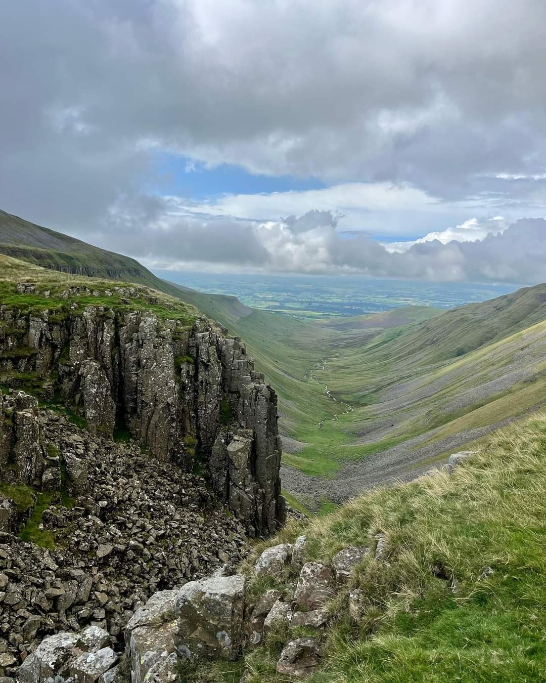
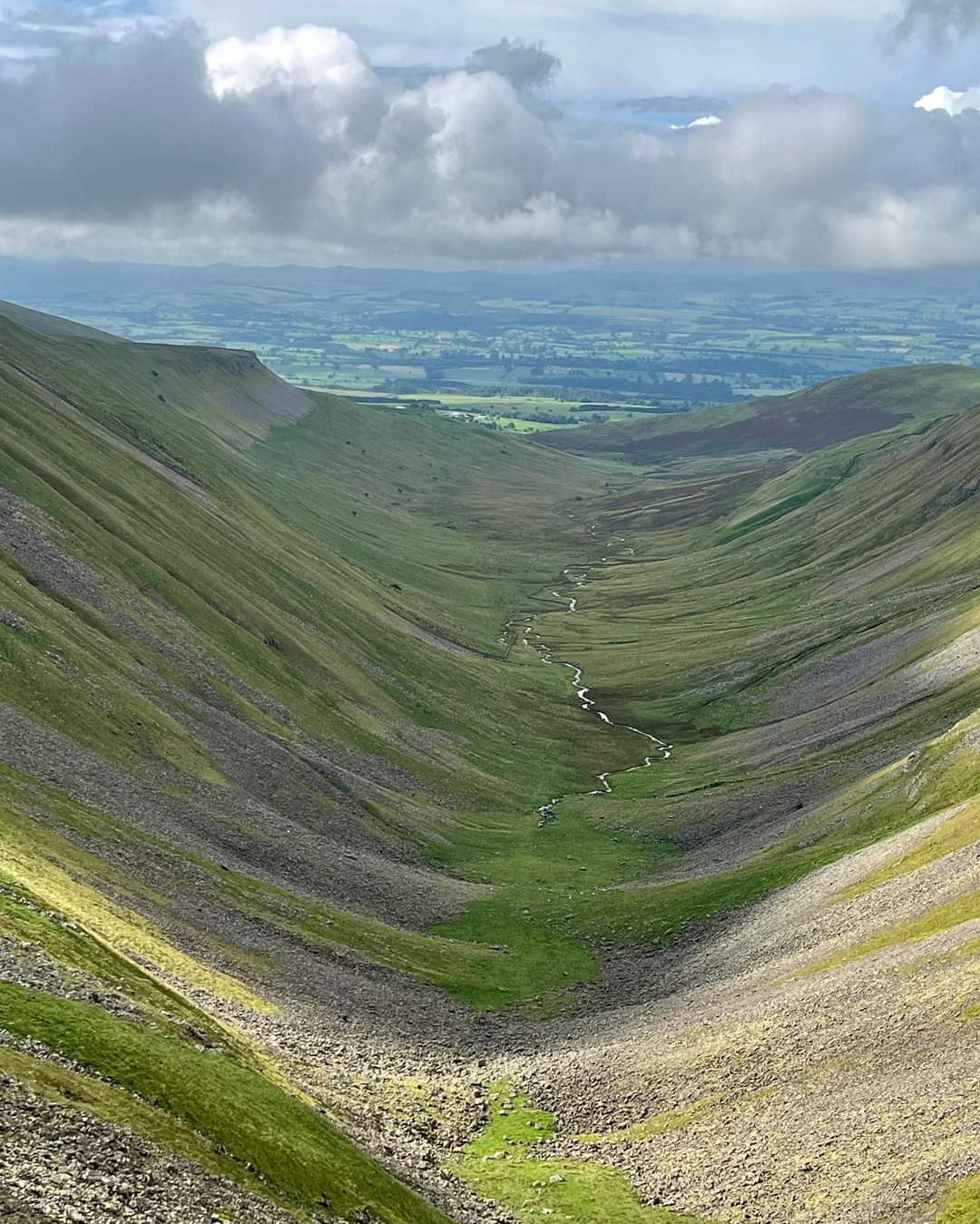
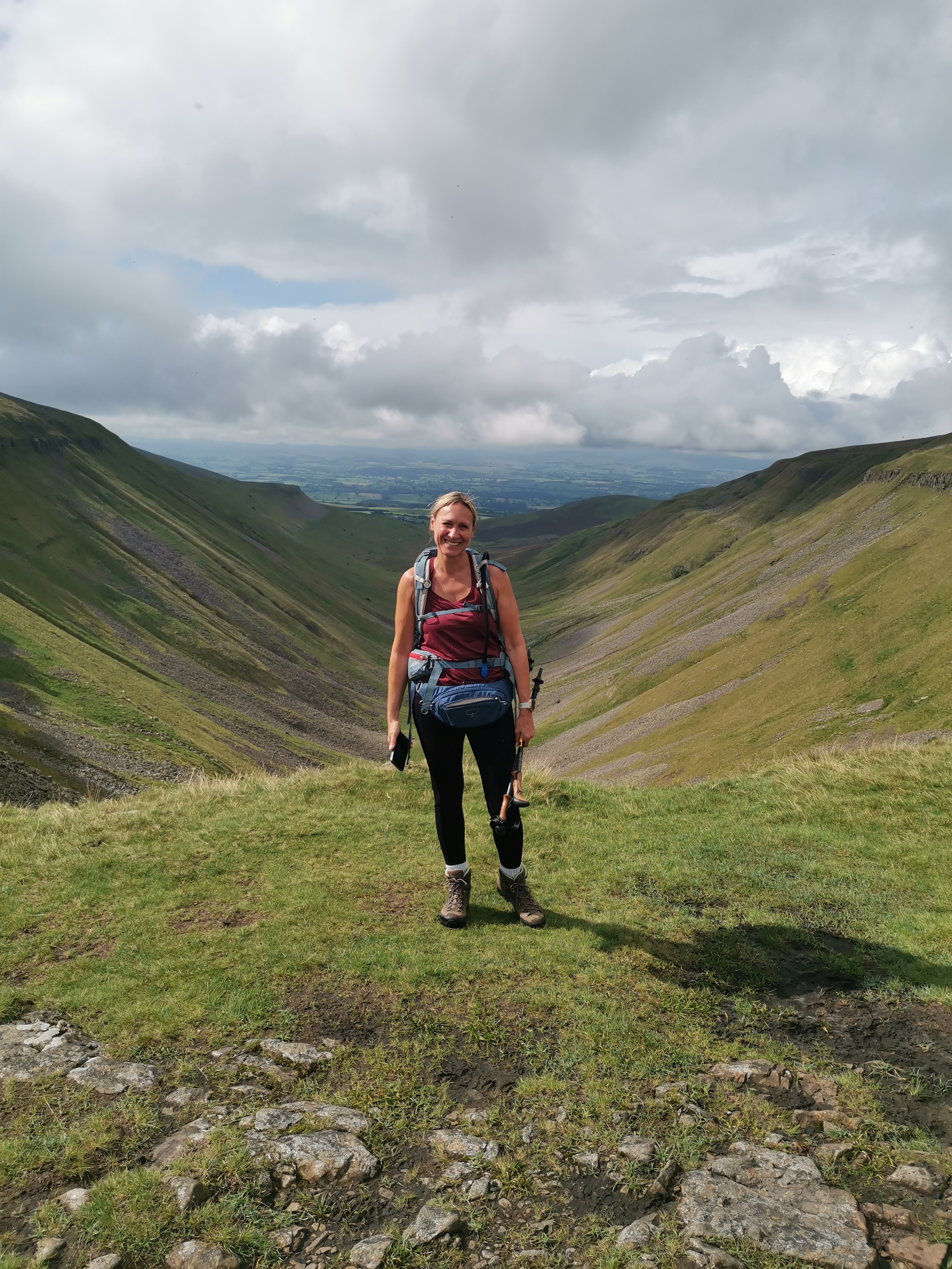
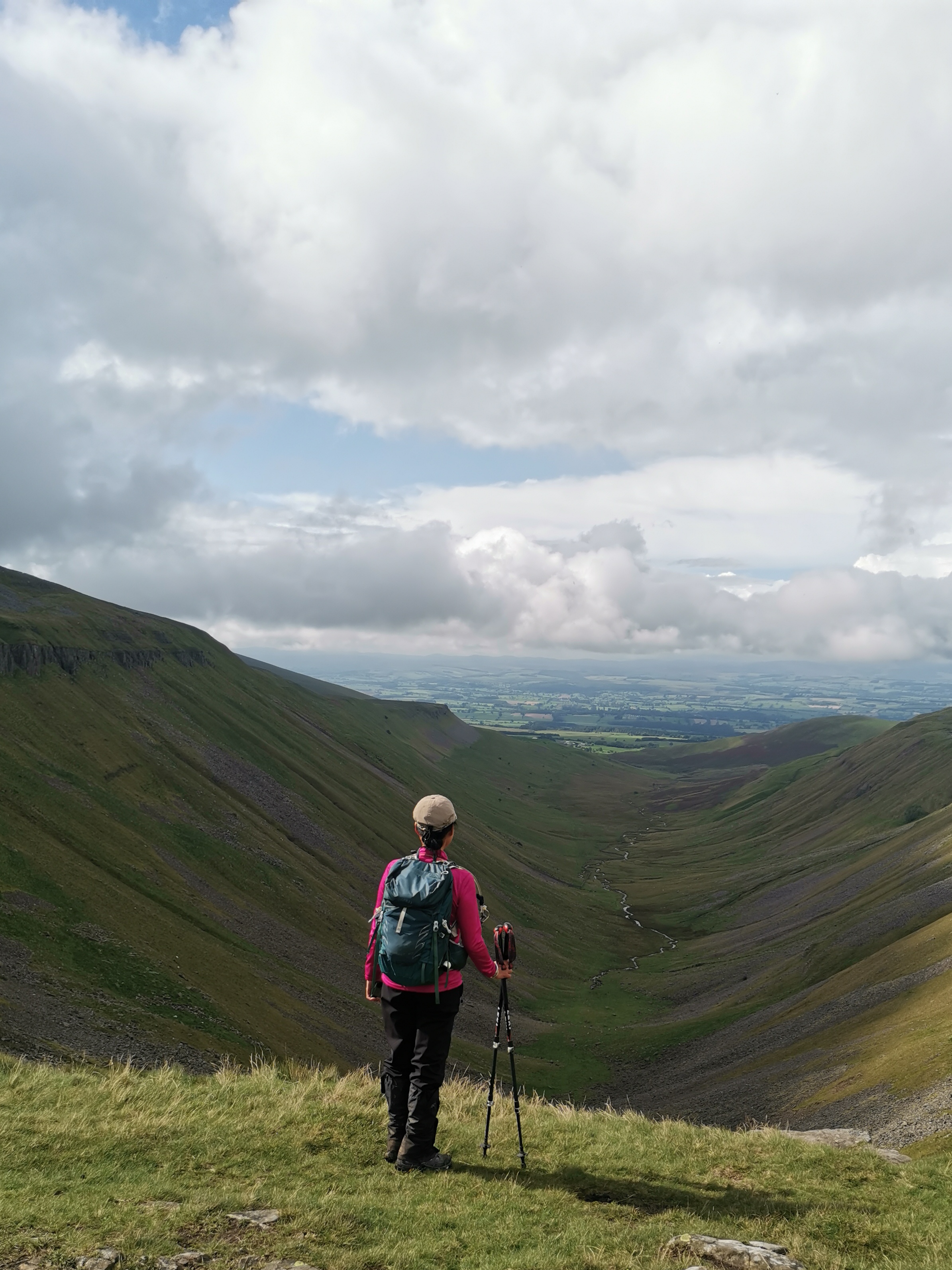
I've been spending some lovely, very enjoyable times with family in Yorkshire over recent weeks, but this weekend I joined my Northumbria group of the LDWA for a c.16/17 mile walk along memory lane - the memory being the 2019 Hadrian Hundred challenge walk on the May bank holiday when the challenge was as much about the appalling weather as the walk itself! The 100 that year, which began in Hexham, included the section of our walk on Saturday which began at Cow Green Reservoir in upper Teesdale heading out west along stony tracks, grass and moorland paths to High Cup Nick, which isn't actually in Northumberland or Durham but in Westmorland and Furness. From the cp we followed the track towards the dam wall of Cow Green Reservoir, crossing over it, down the embankment and over the cattle grid to join the stony track of the Pennine Way. It is an area that has seen industrial mining activity in the past but is now desolate and, in miserable weather can appear rather bleak. But we were again lucky with the weather, even the sun putting in an appearance. Continuing along the north bank of Maize Beck with Mickle Fell rising on the far southern bank and Dufton Fell on our right to the north we turned down towards Birkdale farm. Just beyond Birkdale we cross Grain Beck by a footbridge continuing on a rough track well above Maize Beck dropping down to cross a further footbridge to the southern bank of Maize Beck and a track that is boggy in places. We had our first break just before crossing Maize Beck - a perfect spot - except for the midges which we hadn't anticipated or armed ourselves against!! They emerged in patches along the route but, with a small breeze and moving away from the water, disappeared. The track gains height slowly as it veers away from the beck, a marker stone indicating a sharp right turn down on to High Cup Plain towards High Cup Nick. It is a most dramatic, spectacular geological feature, a classic U-shaped glaciated valley carved deep into the western side of the Cumbrian Pennines that takes your breath away. The 'Nick' is in fact the gap in the Great Whin Sill at the head of High Cup Gill through which High Cup Gill beck flows from the boggy plain above. The rocky crags of the Whin Sill lining the upper reaches of the valley and the views along the Gill to the Eden Valley and misty hills of Lakeland beyond have to be seen to be appreciated - it is magnificent. The darkening clouds signalled rain necessitating waterproofs for some in lighter gear and then we continued along a path to the left of High Cup Gill along Middle Tongue, Trundle Beck being in the valley bottom to our left with Murton Fell climbing up on its far side. Turning back on ourselves at the bluff end of Middle Tongue to follow a narrow path bellow Middle Tongue Crags, we gradually made our way to the valley bottom. The weather had brightened and with waterproofs removed we looked to the head of the valley and the scramble to climb up and through High Cup Nick. On previous visits I'd seen walkers approaching this climb which from the top looks severe but which, in fact, isn't too arduous as long care is taken over the boulder strewn sections (a little slippery after the rain) and I enjoyed the venture and scramble. We sheltered in a rocky nook just below the summit for our lunch before making the final scramble to the top of the 'nick' and headed back along the route we had taken outward bound, not that I had much memory of the initial part of the walk having being so engrossed in conversation! Returning to the dam wall we walked to the top of another outstanding feature courtesy of the igneous stone of the Great Whin Sill - a geological feature that stretches from Cumbria across Durham and Northumberland producing many impressive features. The River Tees flows from Cow Green Reservoir over the Whin Sill in the spectacular waterfall of Cauldron Snout. It is, apparently, the longest waterfall in England at 180m, said to be more of a cataract than a waterfall. As we returned to the cp we looked across the reservoir to the skyline with the readily identifiable Great Dun Fell, Little Dun Fell and, with its summit in mist, Cross Fell. So to Langdon Beck Hotel where we were greeted by open fires, splendid fluid refreshment, much laughter and banter that had me contemplating in the not too distant future (time not being on my side) revisiting the plans of 2019 to climb Kilimanjaro!! Ben Nevis first I think! The menu board and delightful smells from the kitchen had me staying on afterwards for a meal. Many thanks to you Brid for planning and leading the walk, to Julie for bringing up the rear and to all for your companionship - a splendid day was enjoyed by all. (Beryl Massey)Other Files
GPX
A GPX file of the above route may be downloaded by clicking the link below.
Note: GPX files of Group Walks are created by LDWA Group members, and may be downloaded only by other LDWA members. They should not be made available outside the LDWA, and are used at members' own risk.
Login to Download (Members Only)You can use the interactive controls to zoom in and out and to move around the map, or click on a path or a marker for more info. (interactive map help)
You can use the interactive controls to zoom in and out and to move around the map, or click on a path or a marker for more info. (interactive map help)
© OpenStreetMap contributors under Open Database Licence
Rights of way data from selected Local Authorities
Large scale digital mapping is provided by John Thorn
At high zoom levels the route is indicative only.
Gallery

Maps:
You can use the interactive controls to zoom in and out and to move around the map, or click on a marker for more info. (interactive map help)
© OpenStreetMap contributors under Open Database Licence.
Rights of way data from selected Local Authorities.
Large scale digital mapping is provided by John Thorn.


