


Capital Challenge Marshals - ONLY FOR EVENT MARSHALS
Sun 18th Mar 2018
Walk Details:
Event Details Updated
NOTE: This walk is ONLY open to people who are marshalling at the Capital challenge event on 7 April 2018
Event Type
Group Walk
Region
Southern England
Local Group
London
Distance
27ml.
Start Time
08.30
Route
Meet BFI South Bank (under Waterloo Bridge) at the Riverside entrance (currently closed for refurbishment)
Follows the route of the second Capital Challenge event, being held on Sat 7 April
General Notes
We'll stop for coffee at Paddington Station after 4 miles. Lunch will be at a cafe but please bring sandwiches to save time: it's a long walk and we will still be on GMT. Bring a torch! The end will be at or near the View Tube cafe but that will be closed; hipster and shopper options are available nearby.
See also https://www.ldwa.org.uk/London/W/5265/2018.html
Web Site
Start
Finish
Entry Details:
Cost
Walk Report
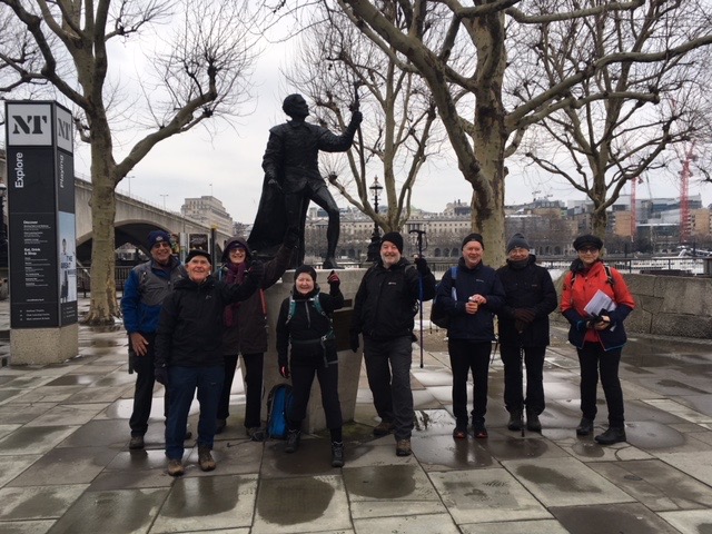
Capital Challenge Marshals Walk, Sunday 18th March 20188 walkers, 28 miles - leader Gordon Parker
8 people ignored the apocalyptic weather forecasts promising a mini-Beast from the East and left the BFI on the South Bank at 08.30. It was neither as cold nor as icy as we had feared: the wind was very cold but nowhere near as strong as we expected. Colin Saunders waved us off and departed with his sore Achilles Tendon to the Trafalgar Square 'Spoons for breakfast. Too cold to snack outdoors we stopped for lunch at the cafe in Golders Hill Park and for a warm drink at the Coal House Cafe in Woodberry Wetlands.
With a great sense of satisfaction it took us 9 hours 42 minutes to reach the View Tube Cafe.
Photograph by Jean O'Reilly; another by Gordon Parker on the group Facebook page
Other Files
Download Walk ReportGallery
Maps:
You can use the interactive controls to zoom in and out and to move around the map, or click on a marker for more info. (interactive map help)
Contains Ordnance Survey data © Crown copyright and database right 2016.
© OpenStreetMap contributors under Open Database Licence.
Rights of way data from selected Local Authorities.
Large scale digital mapping is provided by John Thorn.
© OpenStreetMap contributors under Open Database Licence.
Rights of way data from selected Local Authorities.
Large scale digital mapping is provided by John Thorn.


