


Happy Valley
Wed 22nd Jun 2016
Walk Details:
Figure-of-eight walk around chalk downland rich in wild flowers. Also includes Chaldon church
Entry Details:
Walk Report
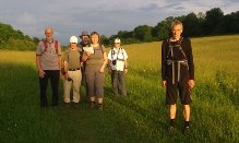
Happy Valley, Wednesday 22nd June 20167 walkers, 6 miles - leader Peter Aylmer
We braved the misery of Southern Railway to gather at Coulsdon South station to try out another of the walks in Peter's forthcoming book.
There's a yew tree avenue at the start before we swooped down into and up out of Happy Valley, a chalk dene on the fringes of Croydon. In its upper reaches we crossed beautiful wild-flower meadows full of yellow-rattle and orchids.
Crossing back through the valley again, we reached Chaldon church, just over the Surrey boundary. Alas it was locked - not surprising at 8pm. Those of us who had been there before recommended the others to come back to view its 'Heaven and Hell' wall painting, full of monsters that are still scary after more than 800 years.
After a longer stretch in the valley bottom, we enjoyed glorious evening light on the ridge of Farthing Down, with distant views to the City. And the return train most of us wanted was conveniently late, so we caught it instead of missed it!
Other Files
Download Walk ReportGPX
A GPX file of the above route may be downloaded by clicking the link below.
Note: GPX files of Group Walks are created by LDWA Group members, and may be downloaded only by other LDWA members. They should not be made available outside the LDWA, and are used at members' own risk.
Login to Download (Members Only)You can use the interactive controls to zoom in and out and to move around the map, or click on a path or a marker for more info. (interactive map help)
You can use the interactive controls to zoom in and out and to move around the map, or click on a path or a marker for more info. (interactive map help)
© OpenStreetMap contributors under Open Database Licence
Rights of way data from selected Local Authorities
Large scale digital mapping is provided by John Thorn
At high zoom levels the route is indicative only.
Gallery
Maps:
You can use the interactive controls to zoom in and out and to move around the map, or click on a marker for more info. (interactive map help)
© OpenStreetMap contributors under Open Database Licence.
Rights of way data from selected Local Authorities.
Large scale digital mapping is provided by John Thorn.


