
Woods and River Views
Sun 9th Aug 2015
Walk Details:
Event Type
Group Walk
Region
Southern England
Local Group
Thames Valley
Distance
c21ml.
Start Time
Start 09.00
Route
Goring Village c.p. (behind High St - free on Sundays)
Web Site
Start and Finish
Entry Details:
Cost
Walk Report
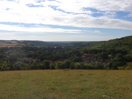
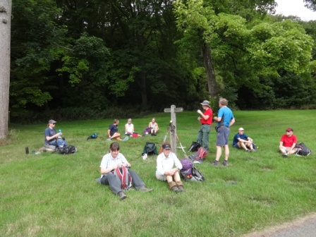
Our leader (David Norbury) offered a choice in view of the hot weather: hills before or after lunch. We picked the former, which meant he then took us up Lardon Chase and, as a geologist, explained the derivation of the Goring Gap (first picture). Proceeding via Bower Farm and across the Ridgeway we took a well-earned break (second picture) at the top of Well Barn Estate (about in the middle of the Chalk succession). A long downhill path through Unhill Woods took us up Kingstanding Hill and Lollingdon Hill, where two opposing tractors caused a minor traffic jam. Lunch was next to the Cholsey and Wallingford Railway, after which we rejoined the Ridgeway at Mongewell and turned onto Swan's Way, to follow it and the Thames Path back to Goring.Words by Graham Croucher, photos by Tony Davis (Surrey group).
Other Files
GPX
A GPX file of the above route may be downloaded by clicking the link below.
Note: GPX files of Group Walks are created by LDWA Group members, and may be downloaded only by other LDWA members. They should not be made available outside the LDWA, and are used at members' own risk.
Login to Download (Members Only)You can use the interactive controls to zoom in and out and to move around the map, or click on a path or a marker for more info. (interactive map help)
You can use the interactive controls to zoom in and out and to move around the map, or click on a path or a marker for more info. (interactive map help)
Contains Ordnance Survey data © Crown copyright and database right 2016.
© OpenStreetMap contributors under Open Database Licence
Rights of way data from selected Local Authorities
Large scale digital mapping is provided by John Thorn
At high zoom levels the route is indicative only.
© OpenStreetMap contributors under Open Database Licence
Rights of way data from selected Local Authorities
Large scale digital mapping is provided by John Thorn
At high zoom levels the route is indicative only.
Gallery
Maps:
You can use the interactive controls to zoom in and out and to move around the map, or click on a marker for more info. (interactive map help)
Contains Ordnance Survey data © Crown copyright and database right 2016.
© OpenStreetMap contributors under Open Database Licence.
Rights of way data from selected Local Authorities.
Large scale digital mapping is provided by John Thorn.
© OpenStreetMap contributors under Open Database Licence.
Rights of way data from selected Local Authorities.
Large scale digital mapping is provided by John Thorn.


